Download
1 / 14
140 likes | 231 Views
Explore the rapid melting of the Lower Grindelwald Glacier, a stark climate change indicator with potential hazards on the landscape and freshwater availability. Witness its transformation from the Little Ice Age to present-day retreat, impacting the valley sides and forming a glacial lake. Learn about the innovative tunnel project mitigating GLOFs by directing meltwater flow. Discover the significance of this environmental shift that demands attention to global warming effects and conservation efforts.

E N D
What happened? Why does it matter? 27th September 2009
Google Earth • Route of the fieldtrip to the Lower Grindelwald Glacier • Grindelwald hike.kmz
One of the indicators of climate change… • Glaciers are melting • Impact on the landscape • Impact on the availability of freshwater • Impact on potential hazards
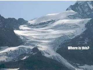
Lower Grindelwald Glacier • The melting of the Lower Grindelwald Glacier is taking place at an extremely fast pace -> increased risk of hazard • The formation of the glacial lake on the Lower Grindelwald Glacier is relatively new (2005)
During the Little Ice Age (approx. 1860), the tongue of the glacier still protruded out of the gorge Continuous retreat (no longer in the gorge itself) The valley sides are no longer supported by the ice -> instability (Felssturz Schlossplatte) The debris that falls from the valley sides protects the ice beneath it from melting. The glacier continues retreating A lake is formed without any overland outlets In spring during times of snowmelt, the meltwater gathers in the lake.
Usually the lake empties during the spring. Water finds a way through the cracks. This can be slow (July 2008) or sudden (May 2008). Often the canal is then blocked up again through either ice or debris. The lake lies on the ice (approx. 200m) – at the bottom of the glacier is a subglacial canal which brings water from the glacier to the gorge and finally to the Lütschine
The tunnel will ensure that the lake can only hold 500 000 m3 – a GLOF in this case would not result in a disaster. The tunnel will have to be lowered each year since the base of the lake is melting as the ice beneath it melts.
The tunnel (built in 2009, completed Dec) is about 2km long and is wide enough for large vehicles to drive through it – cost 15million CHF (subsidised by canton of Bern and federal govt)