TRUE MERIDIAN
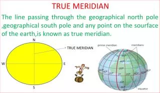
N. TRUE MERIDIAN. TRUE MERIDIAN The line passing through the geographical north pole ,geographical south pole and any point on the sourface of the earth,is known as true meridian. W. E. S. MAGNETIC MERIDIAN

TRUE MERIDIAN
E N D
Presentation Transcript
N TRUE MERIDIAN TRUE MERIDIAN The line passing through the geographical north pole ,geographical south pole and any point on the sourface of the earth,is known as true meridian. W E S
MAGNETIC MERIDIAN When a magnetic needle is suspended freely and balanced properly,unaffected by any magnetic substances,its indicates a direction.This direction is known as magnetic meridian.
ARBITRARY MERIDIAN Sometimes for the survey of a small area, a convenient direction is assumed as a meridian ,is known as arbitrary meridian
GRID MERIDIAN Sometimes for preparing a map some state agencies assume several lines parallel to the true meridian for particular zone, these lines are known as grid lines , and the central line is called grid meridian.
WHOLE CIRCLE BEARING The magnetic bearing of the line measured clockwise from the north pole towards the line ,is known as whole circle bearing .
The magnetic bearing of the line measured clockwise OR anticlockwise from the north pole or south pole towards the east or west,is known as quadrantel bearing. QUADRANTAL BEARING
The magnetic bearing of the line measured clockwise from the north pole or south pole towards the east or west,is known as REDUCED bearing REDUCED BEARING
FORE BEARING The bearing of the line measured in the direction of the progress of survey,is called fore bearing(FB) FB A B BB
BACK BEARING The bearing of the line measured in the OPPOSITE direction of the progress of survey,is called back bearing(BB) BB A B FB
MAGNETIC DECLINATION The angle between magnetic meridian and true meridian is known as a magnetic declination
AGONIC LINE The line passsing through points of zero declination is said to be agonic line ISOGONIC LINE The line passing through points of equal declination is said to be isogonic line 5W 3W 0 3E 5E
LOCAL ATTRACTION When a magnetic needle suspend freely without any influence of magnetic substances, its indicate the direction correctly, but when it influence by any magnetic substances,the direction is not correct,this influence is called local attraction
PRINCIPLE OF COMPASS SURVEY 1.A large area to be surveyed 2.The course of river or coast line is to be surveyed 3.The area is crowded with many details or triangulations is not possible.
BB = FB ± 180 FB = BB ± 180 If BB or FB is less then 180. Than +180. if BB or FB is greater then 180. Than -180 is required.
Magnetic bearing =True bearing ± Declination True bearing =Magnetic bearing ± Declination
CLOCKWISE BB of 1st – FB of 2nd = interior angle FB of 2nd –BB of 1st =exterior angle ANTICLOCKWISE FB of 2nd –BB of 1st =INTERIOR angle BB of 1st – FB of 2nd = EXTERIORangle
INTERIOR ANGLE =(2N-4)×90/N TOTAL ANGLE =(2N-4)×90 N=NUMBER OF SIDES
Equipmen for compass survey 1.pencil 2.eraser 3.sharpner 4.field book 5.arrows 6.ranging rods 7.pegs 8.metric chain 9.prismatic compass 10.tri-square 11.optical square 12.mallet 13.knife 14.plumb boob
When a close traverse is plotted. The starting and finishing points may not be coincide. The distance by whice the traverse fails to close is said to the error .such an error may occur due to mistakes made in measurement of lengths and bearings of the lines or because of an error in plotting.if the closing error exceeds a certain permissible limit ,the field work should be repeated,but when it is within permissible level.it is adjusted geographically.