Download
1 / 20
200 likes | 438 Views
Brent M. Baumhardt GEOG 596A – Capstone Project Proposal July 29-30 2014 Advisor: Prof Peter Guth. Improving Situational Awareness on Instrument Approach Procedures: A GIS Approach to Charting Terrain. Agenda: IAP/Background NTSB Case Analysis Project Goals and Objectives

E N D
Brent M. Baumhardt GEOG 596A – Capstone Project Proposal July 29-30 2014 Advisor: Prof Peter Guth Improving Situational Awareness on Instrument Approach Procedures: A GIS Approach to Charting Terrain
Agenda: • IAP/Background • NTSB Case Analysis • Project Goals and Objectives • Proposed Methodology • Project Deliverables • Presentation Venue and Project Timelines • Anticipated Results
Navigate and land in adverse • weather conditions • Human factors study Legacy Instrument Approach Procedure (IAP) : – Complete IAP extent Planview – Altitude stepdowns Profile – Defined minimum descent heights Minima
Organizes information into • logical flow • Less time searching… • more time flying Volpe Instrument Approach Procedure (IAP) : – Notes/Comm Pilot Briefing Bar – Complete IAP extent Planview – Altitude stepdowns Profile – Defined minimum descent heights Minima
Background: • Technology NAV enhancements • GPS • Electronic Flight Bags (EFB) • Terrain Awareness and Warning System (TAWS) • Improved ATC RADAR coverage
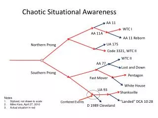
NTSB Case Study: • Accident Number: IAD05MA006 Beechcraft King Air 200, N501RH NTSB Probable Cause: …“Contributing cause of accident was flight crew’s failure to use all available navigational aids to monitor the aircrafts position along the procedure.” B @ 4000’ A C @ 4000’ D @ 2600’ E @ 1400’ 305°
NTSB Case Study: Controlled Flight into Terrain (CFIT): “Controlled flight of airworthy aircraft unintentionally into terrain without awareness”
Project Objectives and Goals: • Improve IAP situational awareness with addition of shaded terrain • Predefine terrain intervals • Clip terrain to extent of planview • Python foundational coding
Proposed Methodology: • 3 functions • Terrain python script • GeoPDF to GeoTIFF python script • Incorporation of GDAL open source raster/vector translation library • Planview clip • All scripts to be loaded as ESRI add-ins • Terrain and planview extents stored in personal geodatabase
Final Raster Meters to Feet Conversion Mosaic Focal Statistics Terrain Python Script Process: Add/ Calculate Field Reclassify Raster to Polygon Final Raster Append to Geodatabase Add/ Calculate Field Contour Generation
Terrain Python Script Process: • Ensure aligned projection and datum. • Elevation reclassifications embedded within script for 1000’ intervals • Discard intermediate data • Field calculations maintain finalized terrain sets based on airport identifiers
Raster Import Tool: Python Bindings Raster Translator IAP GeoTIFF • TerraGo functions costly • Required for Adobe • Required for ArcMap • Open Source translator works • well with numerous languages
Project Deliverables: • Three distinct scripted tools • Terrain generator • Raster translator • Planview clip • Script documentation • Test data and procedures • Presentation at ESRI Users Conference • Research paper
Project Timeline Oct 2014 Nov 2014 Dec 2014 Jan 2015 Feb 2015 ESRI Abstract Research and Script Development Register GEOG 596B Mar 2015 Apr 2015 May 2015 Jun 2015 July 2015 Research Paper Prepare ESRI Presentation Present at 2015 ESRI UC
Anticipated Results: • Automated, documented tools providing flexibility to users • Add terrain to any geo-referenced IAP • Final product consumed within electronic flight bags • Repository of terrain and planview extents for IAP updates
Summary: • Performance based navigation is the future • Improves navigational situational awareness • Alternative to expensive avionic systems