Download
1 / 15
150 likes | 262 Views
Louisiana Department of Environmental Quality 2010 Envirothon Training. Hydrology & Climatology (including Geohydrology ). The Hydrologic Cycle. Consists of inflows, outflows, and storage. Groundwater 101. What is Groundwater?.

E N D
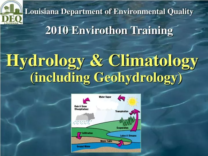
Louisiana Department of Environmental Quality 2010 Envirothon Training Hydrology & Climatology(including Geohydrology)
The Hydrologic Cycle Consists of inflows, outflows, and storage
Groundwater 101 What is Groundwater? Any water beneath the ground surface. Groundwater is stored in aquifers. What is an Aquifer? A water-bearing stratum (or layer) of sand and/or gravel that yields significant quantities of water to wells.
Vadose Zone – water partially fills pore spaces Saturated Zone - all pores are filled; water table is upper boundary
Porosity & Permeability Porosity is the percentage of a material occupied by void space or “pores.” Permeability is a measure of the interconnectedness of the pore space allowing the material to transmit water. The rate at which a material transmits water depends on its total porosity and the size of the interconnections between voids (permeability). Aquifers – gravel, sand Aquitards (impede flow) - clay
** **Aquifers in Southeastern Louisiana collectively called Southern Hills Aquifer System
Cross Section Example • Identify recharge areas • Where are the aquifers confined and unconfined?
Drawdown • Understanding drawdown/cone of depression is important to: • Ensure continuous supply of water (avoid “dry wells”) • Management of overlying land area (vulnerability) • Identify source of ground water (water once discharging to a stream may now be pulled into well)
Impact of Pumping on Natural Ground Water Flow • Strategic Placement of wells • Design of appropriate pumping rates & frequencies • Manipulate ground water flow
Groundwater - Surface Water Interaction Gaining Stream - Altitude of water table higher than altitude of stream-water surface -- groundwater discharges to stream Losing Stream - Altitude of water table lower than altitude of stream-water surface -- surface water recharges groundwater
Groundwater Recharge & Discharge • Recharge • - Infiltration • - Losing Streams • - Artificial • Discharge • - Springs • - Gaining Streams • - Pumping wells • - Flowing artesian wells
Effects of Groundwater Withdrawal on Surface Water Groundwater discharges to stream under natural conditions Pumping well at rate of Q1 intercepts some of groundwater that would have discharged to stream Pumping well at rate of Q2 intercepts additional water and draws water from stream (Q2 > Q1) **Stream quality affects groundwater quality
Impacts of Global Warming Changes in groundwater recharge resulting from changes in precipitation and temperature More severe and longer lasting droughts which could lead to overdraft and saltwater intrusion Possible increased demand Surficial aquifers most sensitive Affects energy use and production