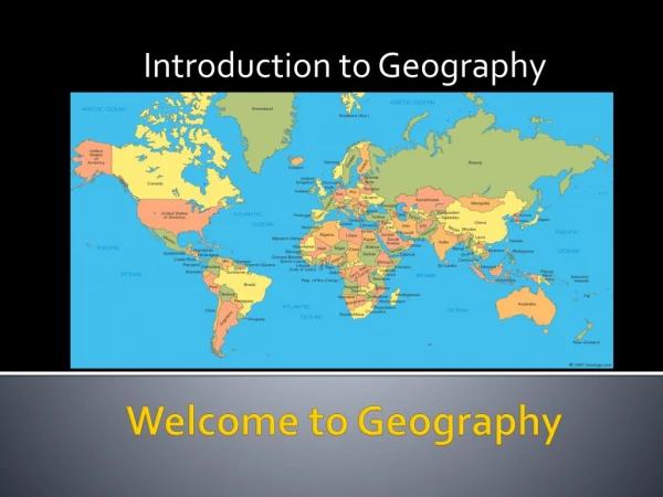
Introduction to Geography
1.13k likes | 2.28k Views
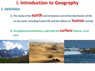
Introduction to Geography. Introduction to Geography. Geography has a major affect on the way people live. We need a mental picture of the whole world, not just certain parts of it. This is “big geography. ”. Africa. U S A. South America. Why is Geography Important?.

Introduction to Geography
E N D
Presentation Transcript
Introduction to Geography Geography has a major affect on the way people live.
We need a mental picture of the whole world, not just certain parts of it. This is “big geography.”
Africa U S A. South America
Why is Geography Important? • It is an essential intellectual building block for understanding world affairs. • Now more than ever, geographic literacy is necessary for us to understand global events.
Geographic Illiteracy • Most Americans could be considered geographically illiterate. • Indeed, educated Americans tend to have less global awareness than educated people in other more developed countries (MDC) of the world.
Results of the National Geographic (Roper) Survey of 2002 - For Europe Countries on quiz: Bulgaria, Croatia, Czech Rep., England, France, Greece, Hungary, Italy, Netherlands, Poland, Romania, and Spain.
Results of the National Geographic (Roper) Survey of 2002 - For Middle East/Asia Countries on quiz: Afghanistan, China, India, Indonesia, Iran, Iraq, Israel, Japan, Pakistan, Russia, Saudi Arabia.
Results of the National Geographic (Roper) Survey of 2002-States
Results of the National Geographic (Roper) Survey of 2002-Population
Results of the National Geographic (Roper) Survey of 2002-Overall
Results of the National Geographic (Roper) Survey of 2002-Travel Experience
The Dangers of Geographic Illiteracy Geographically illiterate individuals cannot make informed decisions about : • Their own economic and social opportunities (housing, jobs, flood risk, etc.). • Their local government’s policies towards the environment or social issues. • The federal government’s policies towards the environment, social issues, or foreign affairs. Being geographically illiterate also limits an individual’s ability to enjoy the diversity and opportunities that the planet offers (especially with regard to travel, or new cultural experiences).
Definitions of World Geography? • The study of the unique combinations of environmental and human factors that produce territories with distinctive landscapes and cultural attributes.
Five fundamental themes of geography 1) Location: the meaning of relative and absolute position on the earth's surface • Sample terms: Latitude and longitude, site and situation, direction, distance, scale • Skills: Map reading, identification • Questions: Where is ____? Where is ____ relative to where I am?
Relative and absolute location • Stand up! • Where were you born? • Where do you live? • Where’s the most beautiful place you’ve ever been?
16. Five themes of geography a. Location answers question “Where is it?” absolute location: 100 Longwood Rd. relative location: south of Middle Country Rd. & East of Yaphank Middle Island Rd.
Five fundamental themes of geography 2) Place: the distinctive and distinguishing physical and human characteristics of locales • Sample terms: Physical and cultural landscapes, sense of place • Skills: Description, compare and contrast • Questions: What does ____ look like? Why? How is it different from ____?
Five fundamental themes of geography 3) Relationships within places: the development and consequences of human-environment relationships • Sample terms: Ecosystems, natural resources, environmental pollution • Skills: Evaluation, analysis • Questions: What human-environment relationships are occurring? How do they affect the place and its inhabitants?
Five fundamental themes of geography 4) Movement: patterns and change in human spatial interaction on the earth • Sample terms: Migration, diffusion, globalization • Skills: Explanation, prediction • Questions: How has this spatial pattern developed? Will it continue to change? What does it mean for the places involved?
Five themes of geography (continued) • Movement answers the question “How do people, goods, and ideas move from place to place?
Five fundamental themes of geography 5) Regions: how they form and change • Sample terms: Formal vs. functional regions • Skills: Synthesis, application • Questions: How has this spatial pattern developed? Will it continue to change? What does it mean for the places involved?
Far East Five themes of geography (continued) Regions are areas that share at least one common feature
Five themes of geography (continued) Human-Environment Interaction focuses on the relationship between people and the environment
Five themes of geography (continued) Human-Environment Interaction focuses on the relationship between people and the environment
16. Five themes of geography (continued) e. Human-Environment Interaction focuses on the relationship between people and the environment
Mountains near the village of Sapa, Vietnam Five themes of geography (continued) Human-Environment Interaction focuses on the relationship between people and the environment
1 Geographic Tools • Geography means “writing about” or “describing” the earth. • Geographers use technological tools such as sonar, satellites, and the global positioning system (GPS) to study locations on the earth’s surface. • Growing in importance are graphic information systems (GIS), which use computer technology to analyze and display data about the earth’s surface to solve geographic problems. • Geographic concepts help organize the way people think about geography.
Did you know that how we “see” the world depends on how we project the world?
The Earth is a sphere. Therefore, it cannot be projected on a flat map without distortion. The question is, which kind of distortion?
On a Mercator projection, invented by Gerardus Mercator in 1569, any straight line is a line of constant compass bearing. This enables a navigator to plot a straight-line course.
Despite the values of the Mercator Projection, it distorts the size and shape of land areas. Fact: South America is 8 times as large as Greenland. Fact: Africa is 14 times as large as Greenland. The Peters Projection is an “equal area” map. It represents areas accurately, but it seriously distorts shapes. Compare the size of Europe to Africa on the two maps. Compare the size of the former USSR to China on the two maps.
Human beings inhabit the biosphere. The biosphere is made up of three layers. • The lithosphere: The solid earth, or outer crust of rock, sand, and soil. • The hydrosphere: The watery realm. About 97 percent of it is the oceans. • The atmosphere: The thin layer of gasses, mainly nitrogen and oxygen.
The lithosphere is in constant, though slow motion. The surface of the earth and the location of its land masses have therefore had a continuously changing history.
The scene of history is continuously moving land masses.Notice in the left column the names of distinct land masses that no longer exist.The red dot represents the location of the Grand Canyon. India 550 Million Years Ago 130 Million Years Ago Pangaea South America 220 Million Years Ago 65 Million Years Ago Laurasia Gondwanaland Today 190 Million Years Ago
The earth is divided into four sections. a. NorthernHemisphere c. Eastern Hemisphere b. Southern Hemisphere d. Western Hemisphere
a. The Atlantic Ocean Most of the earth is covered by the four oceans . b. The Pacific Ocean c. The Indian Ocean d. The Arctic Ocean
a. The Atlantic Ocean Most of the earth is covered by the four oceans . b. The Pacific Ocean c. The Indian Ocean Arctic Ocean d. The Arctic Ocean Atlantic Ocean Pacific Ocean Pacific Ocean Indian Ocean
The world is divided into sevenmajor land masses called continents. c.Asia d.Australia a.Africa b.Antarctica e.Europe f.North America g.South America
The world is divided into sevenmajor land masses called continents. c.Asia d.Australia a.Africa b.Antarctica e.Europe f.North America g.South America North America Asia Europe Africa South America Australia Antarctica
Millions of years ago, the pattern of oceans and continents on Earth looked very different to now….. …..and because of continued change, the pattern will look very different in the future.
Elsewhere, millions of people choose to live and work in these dangerous locations. Why are they there?
We know the Earth used to be covered by millions of hectares of natural forest and grassland. Today, these are gone or rapidly disappearing…… does anyone care?
Many people wonder why geographers spend so much of their time trying to understand how rivers work…… These people know why!
Some natural events are fortunately very rare……. …..in 2004, we remembered why we need to understand and plan for these rare natural events!!
On our beautiful but complex planet, everything that happens is linked to everything else. When we….. • drop a piece of litter • pour a chemical down the sink • chop down a tree • burn coal • build a motorway • catch some fish • fertilize the fields • drive to work or school
2 Changes Within the Earth • How do scientists classify the earth’s major physical characteristics? • What physical processes affect the earth’s crust? • What theories help scientists understand the earth’s past?
2 Physical Characteristics • Geologists envision three layers to the earth: the core, or center, the mantle, or a thick layer of rock around the core, and the crust, the thin rocky layer on the surface. • Landforms and other surface features make up the lithosphere. • The atmosphere is the layer of air, water, and other substances above the surface. • The water in lakes, rivers, and oceans, and water beneath the surface is the hydrosphere. • The large landmasses in the oceans are the continents. • Landforms are categorized by their differences in relief, or the differences in elevation from the highest to the lowest points.