Download
1 / 24
240 likes | 735 Views
Development of HAZUS Earthquake Risk Assessment Capabilities for Southern California SCEC HAZUS Workshop November 13, 2001 HAZUS Past, Future, & Present. Jim Buika Regional Earthquake Specialist Federal Emergency Management Agency San Francisco. FEMA’s National Risk Assessment System

E N D
Development of HAZUS Earthquake Risk Assessment Capabilitiesfor Southern CaliforniaSCEC HAZUS WorkshopNovember 13, 2001HAZUSPast, Future, & Present Jim Buika Regional Earthquake Specialist Federal Emergency Management Agency San Francisco
FEMA’s National Risk Assessment System • Federal Investment Exceeds $17 Million • Earthquake, Wind, and Flood Hazards • All Mitigation is Local • Provides Local Decision Makers with Scientific and Engineering Details to Prioritize Mitigation Projects • HAZUS is at the “Heart” of FEMA’s Mission
Free Multi-hazard Software to Public • Free Support Products • National and Regional Databases • Training & Technical Support • User Manual & Technical Manuals • Continued FEMA software development and enhancements • Runs on a Personal Computer • Requires Geographic Information System Software Investment by User • HAZUS User Group Support Network
ESTIMATED ANNUALIZED EARTHQUAKE LOSS AT THE COUNTY LEVEL • California 74% • Los Angeles County 25%
TOP TEN CITIES AT RISK • Los Angeles • Riverside • Oakland • San Francisco • San Jose • Orange • Seattle • San Diego • Portland • Ventura
Percent Population Change 1990-1998 25 to 134 10 to 25 5 to 10 -5 to 5 -10 to -5 -25 to -10 -60 to -30 Population increases in the last 8 years have tended towards areas of high risk
FEMA’s Commitment to HAZUS 1993 - 2005 • $17.5 Million through 2000 • $40.0 Million though 2005 • Five-Year Strategic Plan, 2002 - 2006 • Technology Development for EQ, Flood, and Wind • Program Management • Marketing and Outreach • Special Studies • Training • CD-rom Distribution
Past Software Releases • HAZUS 97 • HAZUS 99 • HAZUS 99 Service Release 1 • Future Software Releases • HAZUS 99 Service Release 2, December 2001 • Flood Module, December 2002 • Wind, December 2002, 2004 • Web-enabled software 2005
Implementation Strategy • Marketing Study, April 2002, leads to Outreach • Federal Partnerships and Developmental Partnerships • HAZUS User Group Initiative (web site supported) • Course Enhancements • Training Strategy through Private Sector Initiative • Scenario Development for Major Exercises
The Earthquake InformationChallenge • Boundaries of Seismic Disaster Area • Ground shaking, liquefaction, landslides • Boundaries of Secondary Disaster Areas • Flooding, tsunami, fire • Socio-economic Impacts • Homes, population, shelters, businesses, local gov’t status • Jurisdictional and Geopolitical Boundaries • Status of Transportation, Communications, Essential Facilities and Critical Infrastructure • Hazard Specific Information • Tsunami, fire, flood, collapsed structures (USAR), HAZMAT
HAZUS Outputs • Quick Assessment Report • Global Summary Report • Maps “HAZUS 99” ANALYSIS OUTPUT andSUMMER 2000 WORKSHOP GOALS • GOAL ONE: Automated HAZUS Mapping Capability • GOAL TWO: Emergency Management Protocol • GOAL THREE: User-Defined Priority Maps • GOAL FOUR:San Francisco Bay Area HAZUS Risk Assessment Greater San Francisco Bay Area
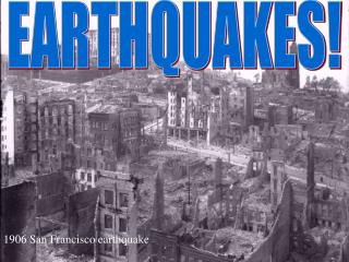
Most Probable EarthquakesForecasted for the San Francisco Bay Area
Accurate Earthquake-Loss Estimates Require Successful Partnerships GeographicInformation SystemProfessionals EarthScientists EarthquakeEngineers • Risk Managers • Local • Regional • Corporate
The HAZUS User GroupPUBLIC – PRIVATE PARTNERSHIP • 600 Members • 175 Organizations • GIS Professionals • Risk Managers • Business Resumption Planners • Emergency Managers • Earthquake Experts • Media Representatives
www.hazus.org Calendar Meeting Reports Press Releases Earthquake Reports HAZUS maps + outputs User Groups around Nation Webmaster, Richard Davies, Executive Director, Western Disaster Center Newsletters Brochures Marketing Information Packet PowerPoint Presentations Conference Resource Manual HAZUS User Group Handbook Conference Booth Advanced HAZUS Training for GIS Professionals National HAZUS Map Book MARKETING MATERIALS
SoCal HAZUS User GroupTen CountiesAccomplishing More Together • Los Angeles • Ventura • Orange • Kern • San Bernardino • Riverside • San Diego • Imperial • Ventura • San Luis Obispo Southern California
SoCal HAZUS User Group Vision • Ten Counties Accomplishing more Together to Build an Earthquake Resistant Community Goal • Reduce the Loss of Life and Property after the Next Major Southern California Earthquake Objectives • Develop an Emergency Management Protocol and HAZUS Automated Mapping Capability for Response Purposes • Create a Comprehensive Earthquake Risk Assessment for Southern California Using HAZUS Software
HAZUS User GroupOrganization Four Committees + User Contributions + Contractor & Five-year Strategic Plan Database Management User Applications Emergency Mgmt. Protocol Marketing • Articles of Incorporation • Formalize Organization • Regional • Local • City • County • Corporation • Tabletop Exercises • Automate ShakeMap into HAZUS
Southern California HAZUS User Group 2001 - 2002 Project Strategies Implement SCEC Risk Assessment + Local Pilot Projects Deliver Post-Earthquake Loss Estimates Train 25 New HAZUS Users SoCal HAZUS User Group Inventory and Improve Databases Develop a Comprehensive Earthquake Risk Assessment for Southern California
Vision Eleven Counties Accomplishing More Together to Build an Earthquake Resistant Community HAZUS User GroupACCOMPLISHMENTS • Leadership & Organization • Training &Technical Support • Marketing & Partnerships • Web Site & Pilot Projects • HAZUS Implementation Model for the Nation Greater San Francisco Bay Area
SUCCESSES Leadership and Organization Local HAZUS training Partnerships Marketing Earthquake Exercises & Earthquake Response HAZUS Pilot Projects LESSONS LEARNED Volunteer leaders will emerge Leads to local acceptance Engage Risk Managers and GIS Professionals as partners Marketing has been key to successful partnerships Scientists seek more details while planners accept HAZUS results for decision making Require agency partnerships SUCCESSES and LESSONS LEARNED
OUTCOMES • Ten counties accomplishing more together • Public-private partnership of earth scientists, engineers, risk managers and GIS professionals • Build disaster-resistant communities • Define physical, social, and economic risk • Save lives and reduces property losses