Exploring Uganda: Geography, Climate, and Land Use of East Africa's Hidden Gem
Discover the unique geography and diverse land use of Uganda, a landlocked country located on the equator, nestled between Tanzania, Kenya, and the Great Lakes region. With a population of over 32 million and a land area of 241,139 square kilometers, Uganda boasts fertile farmlands in the south, extensive swamplands, and rich biodiversity in national parks. The climate varies from temperate in the southwest to hot in the northeast, providing a nurturing environment for agriculture and rich minerals. Learn about Uganda's distinct landscapes and ecosystems that define this beautiful nation.


Exploring Uganda: Geography, Climate, and Land Use of East Africa's Hidden Gem
E N D
Presentation Transcript
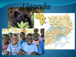
Uganda By Mukiibi Robert
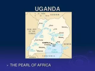
Uganda is a landlocked country astride the equator, about 800 kilometers inland from the Indian Ocean. It lies on the northwestern shores of Lake Victoria, extending from 1 south to 4 north latitude and 30 to 35 east longitude.Uganda is bordered by Tanzania and Rwanda to the south, Zaire to the west, Sudan to the north, and Kenya to the east. With a land surface of 241,139 square kilometers , Uganda has a population of 32,369,558 people and a population density of 134 people per square km.Uganda occupies most of the Lake Victoria Basin, which was formed by the geological shifts that created the Rift Valley during the Pleistocene era. Location and Size
Uganda - Land Use In the southern half of the country, rich soil and rainfall permit extensive agriculture, and in the drier and less fertile northern areas, pastoral economies are common. Approximately 21 percent of the land is cultivated and 45 percent is woodland and grassland, some of which has been cleared for roads, settlements, and farmland in the south. Approximately 13 percent of the land is set aside as national parks, forests, and game reserves.
Uganda - Lakes and Rivers Uganda is a well-watered country. Nearly one-fifth of the total area, or 44,000 square kilometers, is open water or swampland. Four of East Africa's Great Lakes--Lake Victoria, Lake Kyoga, Lake Albert, and Lake Edward--lie within Uganda or on its borders. Lake Victoria dominates the southeastern corner of the nation, with almost one-half of its 10,200-square-kilometer area lying inside Ugandan territory. It is the second largest inland freshwater lake in the world (after Lake Superior), and it feeds the upper waters of the Nile River, which is referred to in this region as the Victoria Nile.
Swampland surrounding lakes in the southern and central regions supports abundant papyrus growth. The central region's woodlands and savanna give way to acacia and cactus growth in the north. Valuable seams of copper, cobalt, and other minerals have been revealed along geological fault lines in the southeast and southwest. Volcanic foothills in the east contain phosphates and limestone.21% of the land is forested area, 90 sq km of the land is irrigated agriculture mainly the the they are public irrigation schemes.
Uganda - Climate Uganda's equatorial climate provides plentiful sunshine, moderated by the relatively high altitude of most areas of the country. Mean annual temperatures range from about 16° C in the southwestern highlands to 25° C in the northwest; but in the northeast, temperatures exceed 30° C about 254 days per year. Daytime temperatures average about eight to ten degrees warmer than nighttime temperatures in the Lake Victoria region, and temperatures are generally about fourteen degrees lower in the southwest.
Except in the northeastern corner of the country, rainfall is well distributed. The southern region has two rainy seasons, usually beginning in early April and again in October. Little rain falls in June and December. In the north, occasional rains occur between April and October, while the period from November to March is often very dry. Mean annual rainfall near Lake Victoria often exceeds 2,100 millimeters, and the mountainous regions of the southeast and southwest receive more than 1,500 millimeters of rainfall yearly. The lowest mean annual rainfall in the northeast measures about 500 millimeters.
References http://www.fao.org/ag/AGP/AGPC/doc/Counprof/uganda.htm http://www.nationmaster.com/red/country/ug-uganda/geo-geography&all=1 http://www.mongabay.com/reference/country_studies/uganda/GEOGRAPHY.html