Download
1 / 26
260 likes | 292 Views
Learn about glaciers and glaciation, including their formation, different types, and how they move. Explore the theory of glacial ages and the distribution of glaciers. Understand glacial budgets and erosion processes.

E N D
Glaciers and Glaciation Prepared by Betsy Conklin for Dr. Isiorho
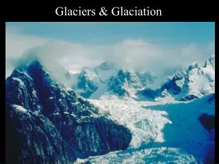
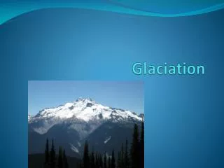
Glaciers • glacier: a large, long-lasting mass of ice, formed on land that moves under the influence of gravity and its own weight • alpine glaciation: found in mountainous regions • continental glaciation: exists where a large part of a continent is covered by glacial ice
The Theory of Glacial Ages • theory of glacial ages: states that at times in the past, colder climates prevailed during which much more of the land surface of the earth was glaciated than at present • because the last episode of glaciation was at its peak only about 18,000 years ago, its record has remained largely undestroyed by subsequent erosion and so provides abundant evidence to support the theory
Distribution of Glaciers • glaciation is most extensive in polar regions, where little melting takes place at any time of year • presently one-tenth of the land surface is covered by glaciers (compared with about one-third during the peak of the glacial ages) • approximately 85% of the present-day glacier ice is on the Antarctic continent, 10% is in Greenland
Types of Glaciers • valley glacier: a glacier that is confined to a valley and flows from a higher to a lower elevation; like streams, small valley glaciers may be tributaries to a larger trunk system • Valley glacier on the flanks of Mount Logan, Canada’s highest mountain
Types of Glaciers (cont.) • ice sheet: a mass of ice that is not restricted to a valley but covers a large area of land (over 50,000 square km); Greenland and Antarctica are the only two places on earth to now have ice sheets • ice cap: a glacier covering a relatively small area of land but not restricted to a valley • Diagrammatic cross section of an ice sheet. Vertical scale is highly exaggerated
Formation and Growth of Glaciers • A new snowfall may be in the form of light “powder snow,” which consists mostly of air trapped between many six-pointed snowflakes. In a short time the snowflakes settle by compaction under their own weight and much of the air between them is driven out. This eventually forms glacier ice.
Formation and Growth of Glaciers (cont.) • ablation\wasted: under the influence of gravity, glacier ice moves downward and is eventually lost or wasted • icebergs: a block of glacier-derived ice floating in water
Glacial Budgets • if, over a period of time, the amount of snow a glacier gains is greater than the amount of ice and water it loses, the glacier’s budget is positive if it expands, if the opposite occurs the glacier’s budget is negative • advancing glaciers: glaciers with positive budgets that push outward and downward at their edges • receding glaciers: glaciers with negative budgets that grow smaller and their edges melt back
Glacial Budgets (cont.) • zone of accumulation: the upper part of the glacier with a perennial snow cover • zone of wastage: the lower part of the glacier where ice is lost, or wasted, by melting, evaporation, and calving • snow line: the boundary between these two altitudinal zones of a glacier is an irregular line; marks the highest point at which the glacier’s winter snow cover is lost during a melt season • terminus: the lower edge of a glacier which moves farther downvalley when a valley glacier has a positive budget
Glacial Budgets (cont.) • A valley glacier as it would appear at the end of a melt season. Below the snow line, glacier ice • and snow have been lost during the melting season. In the zone of accumulation above that line, • firm is added to the glacier from the previous winter fall.
Movement of Valley Glaciers • valley glaciers move downslope under the influence of gravity and their own weight, the rate being variable, ranging from less than a few millimeters a day to more than 15 meters a day • glaciers in temperate climates - where the temperature is at or near the melting point for ice - tend to move faster than those in colder regions - where the ice temperature stays well below freezing
Movement of Valley Glaciers (cont.) • basal sliding: the sliding of the glacier as a single body over the underlying rock • plastic flow: movement that occurs within the glacier due to the plastic or “deformable” nature of the ice itself • rigid zone: the upper part of the glacier
Movement of Valley Glaciers (cont.) • Movement of a glacier. Markers on the glacier indicate the center of the glacier moves • faster than its side. Cross-sectional view shows movement within the glacier.
Crevasses • crevasses: open fissures in a glacier caused when the glacier passes over a steep part of the valley floor and moves faster than the upper part of the ridge zone of ice which cannot stretch to move as rapidly as the underlying ice. Being brittle, the ice of the rigid zone is broken by the tensional forces
Glacial Erosion • faceted: given a flat surface by abrasion • striations: scratches in the rock in the direction of ice movement • rock flour: a powder of fine fragments produced by the grinding of rock across rock • A striated bed rock surface in South Australia
Glacial Valleys • u-shaped valley: characteristic cross-profile of a valley carved by glacial erosion • hanging valley: a smaller valley that terminates abruptly high above a main valley • truncated spurs: ridges that have triangular facets produced by glacial erosion at their lower ends • rock-basin lakes (tarns): a lake occupying a depression caused by glacial erosion of bedrock
Cirques, Horns, and Artes • cirque: a steep-sided, half-bowl shaped recess carved into a mountain at the head of a glacial valley • horn: the sharp peak that remains after cirques have cut back into a mountain on several sides • arte: sharp ridges that separate adjacent glacially carved valleys
Glacial Deposition • till: the unsorted and unlayered rock debris carried or deposited by a glacier • erratic: an ice-transported boulder that has not been derived from the nearby bedrock • Till transported on top of and alongside a glacier in Peru
Moraines • moraines: a body of till either being carried on a glacier or left behind after a glacier has receded • lateral moraines: elongate mounds of till which form along the sides of a valley glacier • medial moraine: a single long ridge of till on a glacier, formed by adjacent lateral moraines joining and being carried downglacier • end moraine: a ridge of till piled up along the front edge of a glacier • ground moraine: a blanket of till deposited by a glacier or released as glacier ice melted
Outwash • outwash: the material deposited by the debris-laden meltwater • drumlins: bodies of till shaped into streamlined hills • esker: a long, sinuous ridge of water-deposited sediment • kettle: a depression caused by the melting of a stagnant block of ice that was surrounded by sediment • Drumlin in New York state • An esker in northeastern Washington
Continental Glaciated Terrain • Drumlin in New York state • An esker in northeastern Washington
Glacial Lakes and Varves • Varve: two thin layers of sediment, one dark and the other light in color, representing one year’s deposition in a lake • Varves from a former glacial lake. Each pair of light and dark • layers represents a year’s deposition. Gradations on ruler are • centimeters
Indirect Effects of Past Glaciation • pluvial lakes: a lake formed during an earlier time of abundant rainfall • fiord: a costal inlet that is a drowned glacially carved valley • tillite: lithified till (evidence of older glaciation comes from rocks called tillites) • A fiord in Alaska
Pictures All pictures used in this power point presentation were taken from the following: Carlson, Diane H., David McGeary and Charles C. Plummer. Physical Geology: Updated Eighth Edition. New York City, McGraw-Hill Higher Education, 2001.