Download
1 / 35
370 likes | 696 Views
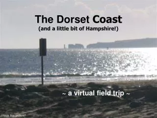
The Dorset Coast (and a little bit of Hampshire!). ~ a virtual field trip ~. I took this picture! . Where it is located. Day 1– The journey to Dorset! . Day 2 – Lyme Regis to Ringstead Bay. Groynes.

E N D
The Dorset Coast(and a little bit of Hampshire!) ~ a virtual field trip ~ I took this picture!
Day 1– The journey to Dorset! Day 2 – Lyme Regis to Ringstead Bay
Groynes An aerial photo of Lyme Regis Bay, showing ‘The Cobb’ (Harbour) and where the River Lim meets the sea
Lyme Regis ~ Charmouth ~ Golden Cap Golden Cap
The coast is unstable because there are numerous situations where porous strata, principally the Chalk and Upper Greensand, lie over impermeable clays. Black Ven between Lyme Regis and Charmouth. Upper Greensand lies over Lower Jurassic clays. The largest coastal mudflow in Europe took place here in the winter of 1958/9 The cliff top at Black Ven
Chesil Beach Isle of Portland The Fleet West Bay (west) Pebbles are ’sorted!’ Portland (east) The gradient of the beach can get very steep
The Isle of Portland When the island was uplifted, a series of massive fractures developed in the limestone.
Weymouth Weymouth is a traditional seaside resort. It is protected by the Isle of Portland. Portland Harbour (South of Weymouth)
Day 3 – Ringstead Bay to St. Alban’s head Durdle Door ~ Lulworth Cove ~ Stair Hole ~ Warbarrow Bay ~ Tynham ~ Broad Bench ~ Kimmeridge ~ Winspit
Durdle Door ~ A Limestone Arch Eventually the arch will collapse to leave a sea stack
Lulworth Cove Chalk Hills stop the cove eroding any further inland Soft sand and clays Limestone Headlands
Stair Hole Small arch is only gap in the limestone. Marine processes eroding further inland
Worbarrow Bay Tyneham from Gadd Cliff (Note the land use) Broad Bench
St. Alban’s Head Winspit (behind) Chapmans Pool Waves shape the coastline. Winspit
Dancing Ledge (+ tidal pool!) Sandbanks Studland Old Harry Swanage Bay Peveril Point Looking out to see from Anvil Point Durlston Head Anvil Point
Swanage Swanage Bay
Old Harry Rocks – A stack Stack Collapsed Undercuttingmeans stack will collapse New cave forming
Studland – Sand Dune System 3 Major dune ridges Little Sea Fieldwork (transects!)
Development of Studland – Blown Sands Little Sea
View over dune slack with further vegetation succession Younger dunes with Marram Grass Actual fieldwork! Hmmmmmm!
Bournemouth Sandbanks Bournemouth Bournemouth Pier Groynes
Christchurch Harbour Spit Hengistbury Head Groynes Long Groyne Sediment Build Up
Hengistbury Head Unstable Cliffs Gullies Groynes Salt Marsh Erosion
House! Barton on Sea Landslides Landslip
Barton on Sea Christchurch Bay Evidence of lanslides Land Use
River Medina ~ A Ria Isle of Wight East Cowes West Cowes River Medina To Newport
That’s it! Day 6 - Back to School