Download
1 / 48
480 likes | 673 Views
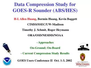
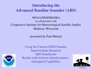
Introducing the Advanced Baseline Sounder (ABS). NOAA/NESDIS/ORA in collaboration with Cooperative Institute for Meteorological Satellite Studies Madison, Wisconsin presented by Paul Menzel. Using the Current GOES Sounder Improvements Required ABS Simulations

E N D
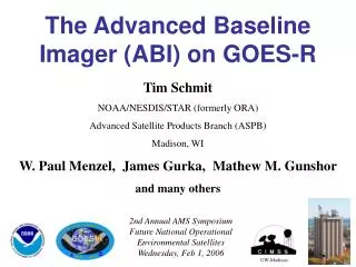
Introducing the Advanced Baseline Sounder (ABS) NOAA/NESDIS/ORA in collaboration with Cooperative Institute for Meteorological Satellite Studies Madison, Wisconsin presented by Paul Menzel Using the Current GOES Sounder Improvements Required ABS Simulations Results with Airborne Interferometers Anticipated Capabilities UW-Madison
GOES Sounder Spectral Coverage Current instrument has 18 infrared bands.
100 GOES (18) Pressure (hPa) 1000 Moisture Weighting Functions GOES retrievals have limited vertical resolution. UW/CIMSS
Evolution of stability seen in GOES LI DPI 18 16 14 12 (12 to 18 UT) Java animation: anigli3m.html
Evolution of profiles retrieved from the GOES Sounder (12 to 18 UT) Java animation: anisks3m.html
View from space OK tornado 3 May 99 1800 UTC View from ground 530 CDT (2330 UTC) 2300 UTC
The GOES-8 Sounder monitors important precursors to the event. Record Earliest Tornado at Milwaukee, WI on 8 Mar 2000 dry slot (dark areas) moist axis (S.E. WI) GOES Retrieval • More information on the web: • http://cimss.ssec.wisc.edu/goes/misc First Guess Retrieval correctly subtracting moisture aloft (within the mid-level dry intrusion) Retrieval correctly adding moisture in the lower levels (within the moist axis)
GOES axis of high LI indicates subsequent storm track 24 Jul 2000
NWS Forecast Office Assessment ofGOES Sounder Total Precipitable Water Summer 99 Forecaster assessment of usefulness of changes in hourly TPW product for precipitation forecast Out of 207 weather cases. - Significant Positive Impact (21.3%) - Slight Positive Impact (50.2%) - No Discernible Impact (27%) - Slight Negative Impact (1%) - Significant Negative Impact (<1%) Figure from the National Weather Service, Office of Services
NWS Forecast Office Assessment ofGOES Sounder Atmospheric Instability Summer 99 Forecaster assessment of usefulness of changes in hourly LI, CAPE, & CINH product for predicting location/timing of thunderstorms There were 248 valid weather cases. - Significant Positive Impact (30%) - Slight Positive Impact (49%) - No Discernible Impact (19%) - Slight Negative Impact (2%) - Significant Negative Impact (0) Figure from the National Weather Service, Office of Services
Positive Impact due to GOES sounder PW (marine) Positive Impact due to Radiosonde (T and moisture) Ratio = A Ratio greater than 1 means the satellite improved the forecast more than the radiosondes over the entire domain (land and marine) 24-hr forecast for Temperature 24-hr forecast for Relative Humidity Eta Data Assimilation System Satellite Data Impact Study for 3 Seasons GOES Sounder Moisture Impact on Eta (Zapotocny et al., 2001) NoGOES / NoRAOB for 10 days in 3 seasons
* Current GOES sounder resolves three tropospheric layers of temperature and moisture every 50 km in clear skies over CONUS plus; in cloudy skies it determines cloud top properties. It is filling gaps in conventional and polar orbiting observing systems. * GOES sounder depiction of changes in time and space are being embraced by the NWS forecast offices * NWP impact from three layers of GOES moisture is positive in Eta model. But, full worth of geostationary data not yet realized; 4-DVAR strategies offer hope. * Revisit of NWS user requirements suggested more coverage and better vertical resolution are the key improvements * Beyond NWP, there are other areas where GOES data can be useful but metrics are elusive
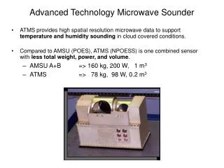
ABS User Requirements (1999 NWS Thresholds) • Resolutions- Temporal: ‘sounding disk’ in 1 hour- Spectral: like LEOs from 3.7-15.4 µm with 0.6 to 2.5 cm-1 res • - Spatial:10 km horizontal res for independent obs • - Spatial:1 km vertical for temp, 2 km for moisture • Accuracies1 degree K temperature; 10% relative humidity • Applications- Nowcasting - Short-range weather forecasting - Longer-range numerical weather prediction
Sounder Comparison (GOES-Current to ABS-Req) CurrentRequirement Coverage Rate CONUS/hr Sounding Disk/hr Horizontal Resolution - Sampling Distance 10 km 10 km - Individual Sounding 30-50 km 10 km Vertical resolution ~3 km 1 km Accuracy Temperature 2 deg. K 1 deg. K Relative Humidity 20% 10%
Spatial Coverage Areas within 62 degrees local zenith angle from GOES-East and GOES-West sub-satellite points are indicated. Threshold coverage rate calls for the 62 arc region, excluding half of over-lap, to be scanned each hour. Current GOES -E and -W sounder hourly coverage is also shown. UW-Madison/CIMSS
GOES Sounder Spectral Coverage Current instrument has 18 infrared bands. Future instrument will have more than 1400 infrared bands. Higher spectral resolution leads to improved vertical resolving power.
ABS: Spectral coverage of the ABS, GIFTS, IASI and the current GOES radiometer sounder
100 100 Advanced Sounder (3074) GOES (18) Pressure (hPa) Pressure (hPa) 1000 1000 Moisture Weighting Functions High spectral resolution advanced sounder will have more and sharper weighting functions compared to current GOES sounder. Retrievals will have better vertical resolution. UW/CIMSS
These water vapor weighting functions reflect the radiance sensitivity of the specific channels to a water vapor % change at a specific level (equivalent to dR/dlnq scaled by dlnp). Moisture Weighting Functions Pressure Weighting Function Amplitude Wavenumber (cm-1) UW/CIMSS The advanced sounder has more and sharper weighting functions
Texas Spikes down - Cooling with height (No inversion) Brightness Temperature (K) Spikes up - Heating with height Ontario (low-level inversion) Detection of Temperature Inversions Possible with Interferometer GOES GOES Wavenumber (cm-1) Detection of inversions is critical for severe weather forecasting. Combined with improved low-level moisture depiction, essential ingredients for night-time severe storm development over Plains can be monitored. Knowing if there is an inversion can also help improve profile estimates.
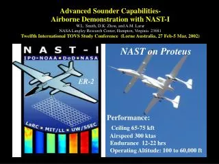
WV vertical structure revealed with Geo-Interferometer Two flight tracks from NAST-I during CAMEX-3 September 14, 1998 Altitude, km --------------------------125 km------------------------- RH %
The 19 channels from the current GOES sounder Sounder spectral coverage over Oklahoma. NOAA/NESDIS/ORA UW-Madison/CIMSS
ABS TRD noise (upper) and CrIS brightness temperature spectra (lower) calculated for low level temperature inversion
ABS/CrIS vs GOES retrieval for low level temperature inversion
Current retrieval strategy: - use all channels in a regression for first guess - then use a sub-set of channels for physical retrieval
Preliminary simulations of ABS/CrIS and GOES retrievals from 590 global radiosondes Geo-I gets <1 K rms for 1 km T(p) and <10% rms for 2 km RH(p)
Simulated CrIS and GOES CTP rms for very high (about 200 hPa), high (about 300 hPa), medium (about 500 hPa), and low (about 850 hPa) clouds with ECA from 0.1 to 1.0 using 75 CONUS raobs.
Simulated Comparison of Current Sounder and ABS Significant improvements in surface and total column parameters are made with interferometers
Geo-Interferometer nears Raob-like depiction of atmosphere Analysis of NOAA global raob data (tropics and mid-lat summer) VAS - past GOES - current G18 - 18 1/2cm-1 chs G50 - 50 1/2cm-1 chs ABS - 2000+ 1/2cm-1 chs RAOB - T to 150mb (Q to 300mb)
ABS Low-Light Visible Capability 4 km resolution Due to the increased dwell times compared to an imager, the sounder visible data may be more sensitive in low-light regions. Better depiction of near nighttime fog and thunderstorms. This may also improve knowledge of the location of the center of tropical disturbances. DMSP OLS nighttime composite image
ABS User Requirements After grd proc implied. Need far field spec: 99% of IRW energy within circle of 1 mr.
ABS Signal-to-Noise LWIR NEDN should be 0.2 for most of LW band ABS Navigation and Registration Want 10% FOV knowledge for band to band. Want 10% within band registration for IRWs.
Advanced Sounder: Improved Forecasts • Advanced sounder provides data for... • Improved quantitative precipitation estimates and forecasts • Reduced size of geographic area affected by Watches • Improved early detection of severe weather & flash floods • Improved forecasts of hail and hail size • Improved detection of lake and sea ice through thin clouds • Improved prediction of fog formation and dissipation • Better microburst potential forecasts (aircraft wind shear; surface winds for transportation; visibility reduction reduction; fire control) • Hurricane intensity and motion • Nighttime major thunderstorm cluster development (formation of low-level inversion and moisture) • Provides input data for mesoscale model initialization
Time series of low-level vertical temperature structure during 9 hours prior to Oklahoma/Kansas tornadoes on 3 May 1999 Truth> Geo-I> Note Geo-I improves depiction of boundary layer heating and surface inversion Current GOES> Geo-I traces evolution of 800 hPa inversion with 60-80% error reduction
3 May 1999 – Oklahoma/Kansas tornado outbreak GIFTS/GOES Retrieved-Temperature Errors Truth> Geo-I Errors> Standard Deviation = 0. 6o Note Geo-I reduces errors by 80% and captures 800mb inversion GOES Errors> Standard Deviation = 3. 5o Geo-I correctly captures the important vertical temperature variations
Time series of low-level vertical moisture structure during 9 hours prior to Oklahoma/Kansas tornadoes on 3 May 1999 Truth> Geo-I> Note Geo-I retains strong vertical gradients for monitoring convective instability Current GOES> Geo-I traces moisture peaks and gradients with greatly reduced errors
3 May 1999 – Oklahoma/Kansas tornado outbreak GIFTS/GOES Retrieved-Moisture (g/kg) Errors Truth> Geo-I Errors> Standard Dev. = 0.9 g/kg Note Geo-I reduces errors and captures low-level moisture peaks and vertical gradients GOES Errors> Standard Dev. = 2.4 g/kg Geo-I correctly captures important vertical moisture variations
GOES Sounder forFuture Mesoscale Models • Future mesoscale models -- relocatable version down to 2 km resolution ~2006 to exploit budgeted new computer resources • GOES will provide hourly data needed by 4-dimensional data assimilation and model system • Will exploit achievements of NASA/NOAA Joint Center for Satellite Data Assimilation Advanced GOES Sounder data in future, high-resolution mesoscale models will reduce weather watch areas
GOES-8 Winds Derived from Half-hourly Water Vapor Imagery Date: Oct. 7, 1995 Time: 1745 UTC GOES interferometer data will yield increased number of vertical layers of wind representation
OSSE demonstrated improved capability of a geostationary interferometer for detailing boundary layer moisture and deriving positive impact in near term forecast.
Significant Findings from Geo-Interferometer OSSE Geo-Interferometer (Geo-I) sees into Boundary Layer (BL) providing low level (850 RH) moisture information; Geo-Radiometer (Geo-R) only offers information above BL (700 RH) OSSE 12 hr assimilation followed by 12 hr forecast
Significant Findings from Geo-Interferometer OSSE Two polar orbiting interferometers (Leo) do not provide the temporal coverage to sustain forecast improvement out to 12 hours. Only the hourly Geo-Interferometer (Geo-I) observations depict moisture changes well enough for forecast benefit. OSSE 12 hr assimilation followed by 12 hr forecast
Summary -- ABS • The Advanced Baseline Sounder overcomes existing instrument limitations. • Geostationary interferometry will resolve high temporal and vertical fluctuations of moisture that are not resolved by current in-situ or satellite measurements. • Only geostationary interferometer observes critical meteorological parameters (temperature, moisture, clouds, winds) with necessary temporal, spatial and vertical resolutions to support future • Nowcasting, • Short-range weather forecasting, and • Longer-range numerical weather prediction. • The Advanced Baseline Sounder will provide required high spectral resolution measurements.
Expectations from the Geo-Interferometer * depicts water vapor as never before by identifying small scale features of moisture vertically and horizontally in the atmosphere * tracks atmospheric motions much better by discriminating more levels of motion and assigning heights more accurately * characterizes life cycle of clouds (cradle to grave) and distinguish between ice and water cloud ( which is very useful for aircraft routing) and identify cloud particle sizes (useful for radiative effects of clouds) * measures surface temperatures (land and sea) by accounting for emissivity effects (the improved SSTs would be useful for sea level altimetry applications) * distinguishes atmospheric constituents with improved certainty; these include volcanic ash (useful for aircraft routing), ozone, and possibly methane plus others trace gases.