Download
1 / 21
230 likes | 515 Views
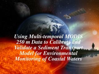
Using Multi-temporal MODIS 250 m Data to Calibrate and Validate a Sediment Transport Model for Environmental Monitoring of Coastal Waters. Richard L. Miller, Carlos E. Del Castillo NASA, Applied Sciences Directorate, SSC Chandrasekhar Chilmakuri, A. Alex McCorquodale, Ioannis Georgiou

E N D
Using Multi-temporal MODIS 250 m Data to Calibrate and Validate a Sediment Transport Model for Environmental Monitoring of Coastal Waters
Richard L. Miller, Carlos E. Del Castillo NASA, Applied Sciences Directorate, SSC Chandrasekhar Chilmakuri, A. Alex McCorquodale, Ioannis Georgiou FMI Center for Environmental Modeling, University of New Orleans Brent A. McKee Department of Earth and Environmental Sciences, Tulane University Eurico J. D’Sa Coastal Studies Institute, Louisiana State University
Importance of Suspended Sediments High concentrations of suspended materials directly affect many water column and benthic processes such as phytoplankton productivity, coral growth, productivity of submerged aquatic vegetation, nutrient dynamics, and the transport of pollutants and other materials. Knowing the concentration, spatial distribution, and dynamics of suspended sediments in coastal aquatic systems is an important goal of many research and environmental monitoring programs. The distribution and flux of suspended sediments is highly variable in coastal environments and vary over a broad spectrum of time and space scales.
Space Observations & Modeling Traditional field measurements can not effectively monitor suspended sediments at the desired spatial and temporal scales Use of remote sensing technology to map suspended sediment is well documented. Problems with clouds, spatial resolution, and revisit time. Use of numerical models for environmental studies is also widely documented. No problem with clouds – however, limited observations for boundary and initial conditions. Potential solution – combine remote sensing and numerical model.
MODIS 250 m Data • MODIS Terra (morning) and Aqua (afternoon)
MODIS 250 m Data • MODIS Terra (morning) and Aqua (afternoon) • ca 1 ½ day revisit time
MODIS 250 m Data • MODIS Terra (morning) and Aqua (afternoon) • ca 1 ½ day revisit time • TSM vs. MODIS Terra (Miller and McKee, 2004) r2 = 0.96
MODIS 250 m Data • MODIS Terra (morning) and Aqua (afternoon) • ca 1 ½ day revisit time • TSM vs. MODIS Terra (Miller and McKee, 2004) Band 1 620 – 670 nm Band 2 841 – 876 nm SSC MODIS X-band ground station
ECOMSED Model The Estuarine Coastal and Ocean Modeling System with Sediment, ECOMSED, is a derivative model from the Princeton Ocean Model (POM). Has a comprehensive sediment model that simulates the combined effects of currents and waves on the resuspension and settling of inorganic particles. Hydrodynamics and the transport components of the model have been calibrated and validated for Lake Pontchartrain, the sediment transport module of the model has not.
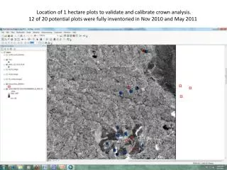
Case Study: Lake Pontchartrain, LA • shallow urbanized estuary • wind-driven resuspension and sediment transport • transport of pollutants / fecal coliform (human health) • nursery to many fish species
Multi-temporal MODIS Images Terra Aqua
Conclusions and Future Work The ECOMSED model calibration was significantly improved using multi- temporal TSM images derived from MODIS 250 m images The model captured the general spatial distribution as indicated in the MODIS images; however, the model tended to over-estimate suspended sediment concentrations in shallow areas. Future improvements include: field samples to better calibrate MODIS images (i.e., Aqua), field studies to better define the spatial variation in the sediment parameters in the numerical model, and modifying the model to accept spatially varying sediment and wind fields. Conduct numerical model simulations and processed image data to provide reliable estimates of storm water discharge and fecal coliform distributions.
Planet Earth - a Dynamic System Forces acting on the Earth system Earth system responses IMPACTS Feedbacks
Overarching Science Questions How is the Earth changing and what are the consequences of life on Earth? • How is the global Earth system changing? • What are the primary forcings of the Earth system? • How does the Earth system respond to natural and human-induced changes? • What are the consequencesof changes in the Earth system for human civilization? • How well can we predictfuture changes in the Earth system?
Carbon Management Aviation Energy Management Air Quality Coastal Management Homeland Security Disaster Management Ecological Forecasting Water Management Invasive Species Public Health Agricultural Efficiency Applications of National Priority