Download
1 / 27
270 likes | 563 Views
Lecture 1 Course Introduction and Geology of the Chesapeake Bay. Lecture Outline. I Course Introduction A) Instructor Introduction B) Course Overview i. Times and Location ii. Required Texts iii. Class URL and Web Resources C) Course Schedule i. Important Dates

E N D
Lecture 1 Course Introduction and Geology of the Chesapeake Bay
Lecture Outline I Course Introduction A) Instructor Introduction B) Course Overview i. Times and Location ii. Required Texts iii. Class URL and Web Resources C) Course Schedule i. Important Dates ii. Structure D) Policies i. Attendance and Participation ii. Grading iii. Honor Code iv. Laboratory E) Tests II Why Study Geology? Lecture 1 i
Lecture Outline III Geology of the Chesapeake Bay A) Formation of the Chesapeake Bay B) Characteristics and Importance of the Bay C) Geography of the Bay D) Physiographic Provinces of the Bay Drainage Area i. The Appalachian Plateau ii. Ridge and Valley - Appalachian Mountain Section - Great Valley Section iii.Blue Ridge iv.Piedmont - Mesozoic Lowlands Section - Piedmont Lowland Section - Piedmont Upland Section v. Coastal Plain E)Chesapeake Bay Bolide i. Event Lecture 1 ii
Lecture Outline III Geology of the Chesapeake Bay E)Chesapeake Bay Bolide ii. Influence - Stratigraphy - Geomorphology - Groundwater - Modern Sea Level Changes IV Conclusions Lecture 1 iii
Instructor Information Stephen B Parsons Oceanography 327 683-6058 (offc) 581-5223 (cell) sparsons@ocean.odu.edu Office Hours: Daily 1030-1230; other times by appointment Lecture 1 I.A
Course Overview Goal This course gives an introduction to physical geology, which includes the basic materials and processes that form the earth, the application of scientific methodology to understanding the earth, and the processes that shape and change the earth. Special attention will be paid to the concept of the rock cycle and the theory of plate tectonics. Meeting Times Mondays, Wednesdays, and Fridays, 1200-1250 Texts Plummer, C.C., McGeary, D., and Carlson, D.H., 2002. Physical Geology, 9th edition, McGraw-Hill, 574pp. Busch, R.M. And Tasa, D., 2002. Laboratory Manual in Physical Geology, 6th edition, Prentice-Hall, 288 pp. Class URL http://www.ocean.odu.edu/~spars001/geology_111/index.html Lecture 1 I.B
Course Schedule 09/26/03 Exam 1 Composition of the Earth 10/31/03 Exam 2 Historical Geology and Geomorphology 12/05/03 Exam 3 Earth Architecture and Geophysics 12/12/03 Comprehensive Final Exam Lecture 1 I.C
Course Policies Attendance Grading Weights Exams 1-3 1/3 of final grade Final Exam 1/3 of final grade Laboratory 1/3 of final grade Scale 93 -100 90 - 92 87 - 89 83 - 86 80 - 82 77 - 79 73 - 76 70 - 72 A A- B+ B B- C+ C C- Honor Code Laboratory Lecture 1 I.D
Tests True/False T F 1. The Earth's lithosphere is composed entirely of crustal material. Multiple Choice ____ 2. Approximately how old is the Chesapeake Bay? (a) 1,000 years (d) 1,000,000 years (b) 10,000 years (e) 10,000,000 years (c) 100,000 years Short Answer 3. Name four of the eight rock-forming minerals common to igneous rocks. Lecture 1 I.E
Why Study Geology? • provides information on the structure of the Earth, its evolution and the processes that shape it • preserves the history of our planet providing insights into lost worlds of Earth's past • provides clues to Earth's past and future climate • links the very large with the very small • provides the food we eat and the water we drink • provides the raw materials of everyday life and teaches us about their conservation • provides information to help prepare for geologic hazards Lecture 1 II
Formation of Chesapeake Bay Lecture 1 III.A
Characteristics and Importance of the Chesapeake Bay • Largest Estuary in the United States • What is an estuary? • Supports more than 3600 species • 2700 plant species • 348 species of finfish • 173 species of shellfish • 29 species of waterfowl • Commercial resource • 500 million lbs seafood/year • 2 major ports • Recreational resource Lecture 1 III.B
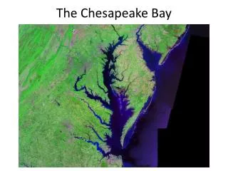
Geography of the Chesapeake Bay Lecture 1 III.C
Geography of the Chesapeake Bay Length: 332 km Width(max): 56.3 km Width (min): 5.5 km Area: 11,400 km2 Depth (ave): 6.4 m Shoreline: ~19000 km Ave. Tidal Range: 0.3 m - 1.0 m Volume: 6.813 x 10¹³ l Lecture 1 III.C
Geography of the Chesapeake Bay Drainage Area: 165,800 km2 50% of H2O from Atlantic Ocean 50% of H2O from freshwater sources 50% from Susquehanna ~90% from western rivers ~10% from Eastern Shore streams Lecture 1 III.C
Physiographic Provinces Lecture 1 III.D
Physiographic ProvincesThe Applachian Plateau elevated plateau with dendritic drainage pattern 280 million years ago it was a marshy sea the horsetail ferns that populated that sea have been compressed and now form the large coal seams that run through the region heavily forested greatest rainfall of all Chesapeake Bay provinces Lecture 1 III.D.i
Physiographic ProvincesRidge and Valley • parallel ridges and valleys of the Applachian Mountains • form an alternating pattern. • slightly lower in elevation from Appalachian Plateau • mountainous soils composed of clay and clay loams as • well as sandy and stony loams. • deep limestone soils make this region extremely fertile • dry climate Lecture 1 III.D.ii
Physiographic ProvincesThe Blue Ridge narrow line of old mountains extending from Carlisle, PA south to Gainesville, GA some rocks are 1.2 billion year old granites sedimentary rocks here were formed when Africa was ripping away from Virginia forming the Iapetus Ocean early in the Cambrian Lecture 1 III.D.iii
Physiographic ProvincesThe Piedmont • gently rolling topography • deeply weathered bedrock composed of igneous and metamorphic rocks, some from ancient volcanic island arcs • some rocks may have been formed outside • North America • Triassic basins include • alluvial fan conglomerates • tropical lake and mudflat deposits Triassic basins Lecture 1 III.D.iv
Physiographic ProvincesThe Coastal Plain youngest rocks terraced landscape bounded on west by Fall Line underlain by wedge of sediments increasing in thickness with distance from the fall zone (A) to more than 4000m under shelf 1200m of young sediments cover the Chesapeake Bay impact structure Lecture 1 III.D.v
Chesapeake Bay Bolide Lecture 1 III.E
Chesapeake Bay BolideEvent 35 million years ago billions of kg of water instantly evaporated billions more shot 100km into atmosphere tsunamis 1.2km high Lecture 1 III.E.i Graphics: Michael Hall, Virginian-Pilot
Chesapeake Bay BolideInfluence on Stratigraphy USGS USGS Lecture 1 III.E.ii
Chesapeake Bay BolideInfluence on Geomorphology Michael Hall, Virginian-Pilot Lecture 1 III.E.ii
Chesapeake Bay BolideInfluence on Groundwater USGS Michael Hall, Virginian-Pilot Lecture 1 III.E.ii
Chesapeake Bay BolideInfluence on Modern Relative Sea Level Lecture 1 III.E.ii