Download
1 / 15
150 likes | 294 Views
Presentation by: Jason R. W. Merrick. Obtaining Vessel Routes from VTOSS Data. GWU Personnel: Dr. J. Rene van Dorp VCU Personnel: Dr. Jason R. W. Merrick Puget Sound Harbor Safety Committee Presentation December 2012. Before Cleaning. Trip IDs. Identifying a Continuous Route.

E N D
Presentation by: Jason R. W. Merrick Obtaining Vessel Routes from VTOSS Data GWU Personnel: Dr. J. Rene van Dorp VCU Personnel:Dr. Jason R. W. Merrick Puget Sound Harbor Safety Committee Presentation December 2012
Identifying a Continuous Route • Sort by Vessel Name and then Timestamp • If the Trip ID is the same, then points are on the same route • If the Trip ID changes, but the Vessel Name is the same and less than an hour between points, then points are on the same route • This means you have to fix • Different spellings of the same Vessel Name • Multiple vessels with the same Vessel Name
Finding 12:xx pm Points • Parse the points sorted by Vessel Name and then Timestamp • If the points are time stamped 12:xx pm • Search for the points on this route either side of 12:xx am • Determine whether the point is closer to those either side of 12:xx am or those either side of 12:xx pm • Move points if necessary • Special case if the point would be the first on the route or if it is the last point where it is • Repeat Code Sorted by Vessel Name then Trip ID then Timestamp
Fixing Errors • Parse through points on a continuous route • Take each consecutive set of three points and consider the triangle • Calculate the perpendicular distance between the middle point and the line between the first and third • If the perpendicular distance is greater than the maximum distance the vessel could travel in the time between the first and third point • Delete middle point • You can also check that the perpendicular distance is greater than zero otherwise the middle point isn’t needed on the route • Don’t need three points to draw a straight line
Finding Some Missing Data • Some routes where a new Trip ID is started by the same VTS, but then the original Trip ID resumes later • Parse continuous route • Look for these cases • Change new Trip ID to the original • Ensure these cases are not 12:xx pm points that should be 12:xx am points on a different route
Manual Fixing • These will need to be manually fixed
Generating Heat • Very computational • Database sizes require that data is separated into months (1-2 GB each) • Cleaning one month of data for just TUG TOW BARGE took 5-7 hours • Tug data is cleaned • Moving on to everything else but tankers and ferries • Vessel Name disambiguation and spelling correction complete • First month of data preliminary cleaning complete • Now tuning algorithms to maximize cleaning before cleaning remaining months
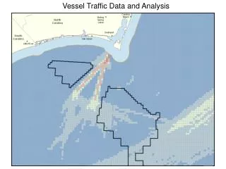
Moving Away from Representative Routes • In previous analysis, we couldn’t clean every route • Each bulk carrier going from Vancouver to Tacoma followed the same representative route • Had to choose the cleanest route we could get • Now we are cleaning all routes • Each vessel will follow its route • Let’s look at some tug routes