Download
1 / 24
240 likes | 547 Views
A SYSTEMIC RADIOMETRIC CALIBRATION APPROACH FOR LDCM AND THE LANDSAT ARCHIVE. LDCM Science Team Meeting January 9-11, 2007 EROS Data Center . Dennis Helder, EE & CS Dept, SDSU Dave Aaron, Physics Dept, SDSU Jim Dewald, SDSU IP Lab Tim Ruggles, SDSU IP Lab Chunsun Zhang, SDSU GISc Center.

E N D
A SYSTEMIC RADIOMETRIC CALIBRATION APPROACH FOR LDCM AND THE LANDSAT ARCHIVE LDCM Science Team Meeting January 9-11, 2007 EROS Data Center Dennis Helder, EE & CS Dept, SDSU Dave Aaron, Physics Dept, SDSU Jim Dewald, SDSU IP Lab Tim Ruggles, SDSU IP Lab Chunsun Zhang, SDSU GISc Center
A SYSTEMIC RADIOMETRIC CALIBRATION APPROACH FOR LDCM AND THE LANDSAT ARCHIVE • Consistent calibration of the Landsat archive through use of pseudo-invariant sites • Techniques for relative gain calibration/correction of large linear arrays • Vicarious calibration of LDCM and Landsat TM/ETM+ instruments
Current Landsat 5 TM Calibration • Calibration based on best data available in 2000 • IC • Vicarious Calibration • Cross-calibration with Landsat ETM+ • Decaying exponential plus constant model integrated all data sources • Particularly good fit for band 3, maybe band 4 • Within the error bars for bands 1 and 2 • Less precision in cold focal plane bands 5, 7
L5 TM Revised Calibration Procedure • Historically, the radiometric calibration procedure used the detector’s response to the IC on a scene-by-scene basis to determine the gain and offset of each detector • Effective May 5, 2003, L5 TM data processed and distributed by the USGS EROS was radiometrically calibrated using a new procedure and revised calibration parameters • The modified calibration approach no longer uses the IC gain on a scene-by-scene basis for calibration of the reflective bands
Additional Calibration Sources • Pseudo-invariant sites • Work done or in progress by several groups: • France • Australia • U.S. – GSFC & SDSU • Concept: • Many locations on the Earth exhibit ‘constant’ surface reflectance and BRDF over short and long periods of time • Locations are homogeneous spatially and temporally • Atmospheric effects are minimal, fairly constant, and can be accounted for in a reasonably simple manner • Current sites are primarily located in deserts • Additional vicarious calibration data • UAZ incorporated new sites at Railroad Valley and Ivanpah Playa • Many new data points recorded on a regular basis by UAZ & SDSU • Standardization of data collection techniques enhanced repeatability • Many opportunities for comparison to other sensor systems
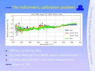
Additional Calibration Sources • Desert Sites used in this study • Saharan location: Path 181 Row 40 • Collaboration with CNES • Processing steps: • Center 3000 x 3000 pixels used • Level 0R data • Check for saturated pixels (Band 5) • Sun angle > 48.5o • Earth-sun distance correction • Outgassing correction for cold focal bands
Potential Arabian & African Sites Number of potential sites = 51
Additional Saharan Middle East Desert Sites Libya 1 Arabia 1 Egypt 1 Libya 4
EROS Archive of Potential Arabian & African Sites * Sites presented by Cosnefroy et al. ** EROS Archive through Dec 2006
EROS Archive of US Sites * EROS Archive through Dec 2006
Rail Road Valley & Lunar Lake NV • 38.5040 N 115.6920 W • Elevation 1.3 km ASL • Low aerosol content • Desert – no vegetation • Flat spectral reflectance • Cloud cover during winter and late summer • But it’s a small site!
Consistent calibration of the Landsat archive through use of pseudo-invariant sites • Major Objectives • Develop a worldwide set of sites • Develop techniques to deal with ‘small sites’ • Geometric & Radiometric processing • Automate the process • Develop lifetime radiometric gain trending for Landsat archive • Use as an additional tool for absolute gain and cross-calibration of Landsat archive
Techniques for relative gain calibration/correction of large linear arrays • Relative Gain—whiskbroom to pushbroom scanner issue: • Landsat 4/5 TM—16 detectors/refl. band + 4 thermal det. 100 det. • Landsat 7 ETM+ -- add the pan band & 30m thermal band 136 detectors • Advanced Land Imager 320 multispectral detectors/sca x 4 sca’s/band x 9 bands + 960 pan detectors/sca x 4sca’s/band = 15,360 detectors • LDCM ≥ 57,000 detectors! Relative gain estimation is a critical element for LDCM! • Methods to estimate Relative Gain • Image uniform fields • 90o yaw maneuvers • Statistical based methods
Statistics-based Relative Gain Algorithm Overview • Cumulative Histogram statistics extracted from the databases to be used as an input to the algorithm • First Pass : Calculate scene statistics from bulk trending database - Screen data for scenes that likely exercise detectors over significant linear range • Second Pass: Calculate detector statistics and SCA-level statistics(µ and σ) for all valid scenes • Calculate relative gains from detector and SCA-level statistics • Relative gain for ith detector gi,relative = (σi/ σ) • Correct relative gains within an SCA • Calculate SCA discontinuities using 10 overlaps detectors from adjacent SCA’s • Correct SCA discontinuities
1. Relative SCA-to-SCA Correction based on the ten detector overlap 1. Post-Image Bias removal 2. SCA based RG correction EO12005070130654_SGS_01
EO12005070130654_SGS_01 SCA 3 SCA 2 SCA 4 SCA 3 Linear 2 % Stretch SCA 2 SCA 1 SCA 3 SCA 2
Techniques for relative gain calibration/correction of large linear arrays • Summary/Objectives: • Develop theoretical basis for scene statistics approach • ‘Perfect’ the technique using ALI data as a precursor • Develop methodology for near 90o yaw maneuvers • Explore usage of near uniform Earth fields and internal lamps for relative gain estimation
Vicarious calibration of LDCM and Landsat TM/ETM+ instruments • History of vicarious calibration of Landsat 5 TM and Landsat 7 ETM+ • Continuation of this activity • Vicarious calibration of LDCM instrument…(?)
A SYSTEMIC RADIOMETRIC CALIBRATION APPROACH FOR LDCM AND THE LANDSAT ARCHIVE • We’re very pleased to be a part of this team! • Thanks! • Questions?