Download

1 / 8
80 likes | 194 Views
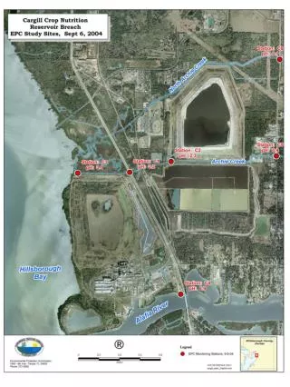
NAME Tier 1 Atmospheric/Oceanic Process and Budget Studies using ISS Data. Richard H. Johnson, Paul E. Ciesielski, Brian D. McNoldy Colorado State University. US. US. US. US. US. US. I. I. I. I. = SMN Op. RAOB. 88D. 88D. M5. M5. 88D. M5. 88D. M5. M5. 88D. 88D.

E N D
NAME Tier 1 Atmospheric/Oceanic Process and Budget Studies using ISS Data Richard H. Johnson, Paul E. Ciesielski, Brian D. McNoldy Colorado State University
US US US US US US I I I I = SMN Op. RAOB 88D 88D M5 M5 88D M5 88D M5 M5 88D 88D 88D 88D US = U.S. Op. RAOB = SMN 5 cm Doppler Radar = WSR 88D Doppler Radar 10P = S-band Dual-Pol. Radar M M M M M M M M = ISS Profiler/ RAOB I = NOAA R/V Ronald Brown 5 / .85 cm Dopp. Radars, Profilers, RAOB, Fluxes, aerosols, SST/CTD/ADCP RAOB Budget network = UHF Profiler w/RASS TIER 1 SOUNDINGS M M 10P M M NOAA ETL surface flux system
• Puerto Penasco • 3 NCAR ISSs (GPS sounding, UHF profiler, RASS, sfc station); 1 GLASS ISS sounding network designed to determine: – initiation mechanisms, structure, and propagation of surges – mechanisms for diurnal cycle of convection – air-sea exchanges, upper-ocean changes – atmospheric budgets, latent heating profiles over land and ocean • Kino Bay • SMN soundings • • • • Los Mochis Loreto or Santa Rosalia • • S-POL • • • fluxes, upper-ocean
ISS Network 3 ISSs (Integrated Sounding Systems) GPS sounding system UHF wind profiler (winds up to ~ 4 km) RASS (Radio Acoustic Sounding System) (Tv profiles) Surface met station 1 mobile sounding system (GLASS) GPS sounding system Surface met station
Data Processing/Dissemination Plan Real Time • All “preliminary” data on the web • Soundings onto GTS – PIBAL messages are generated – Data available for operational models • Local internet service required • CSU soundings-monitoring/processing/display facility Quality-controlled data (ATD ISS staff) • Six months after project, all data • Consensus profiler winds (30-min intervals) • Exabyte tapes, DVD, or FTP; ASCII or net CDF • Further quality control by JOSS/CSU?
Special Issues Staffing • 10 operators required continuously • Crew change at midpoint recommended 20 operators! • Training required • Local requirements: interpreters (?), safety Siting (to be determined) • 16’ 16’ area, unobstructed view of sky for 50’ radius, 8’ above ground • unobstructed fetch, no shadowing Supplies • 130 T-cylinders of helium
Field Coordination Requirements Launch frequency • IOP – 6 daily at 2 southern sites – 2 daily at 2 northern sites • non-IOP – 2 daily at all sites • 24-h notice needed for IOPs (possibly shorter) IOP decisions ( 10 IOPs, averaging 2 days each) • Coordinate with aircraft, radar, other ops • Assign IOPs/optimize resources to satisfy NAME objectives (surges, MCSs, diurnal cycle, easterly waves, upper-level disturbances)