
Streamflow Data Assimilation for Numerical Weather Prediction Models in the Upper Enz Basin
This project focuses on the assimilation of streamflow measurements to enhance soil moisture initialization using advanced numerical weather prediction models. Conducted over two years, this study utilizes the Ensemble Kalman Smoother and Retrospective Ensemble Kalman Filter methodologies. It examines the hydrological dynamics within the 219 km² Upper Enz catchment area, leveraging models such as TERRA-ML and LARSIM. Key outcomes include improved parameterizations for vertical soil water flows and data assimilation processes that could inform future flood forecasting.

Streamflow Data Assimilation for Numerical Weather Prediction Models in the Upper Enz Basin
E N D
Presentation Transcript
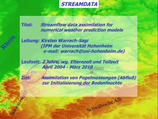
STREAMDATA Höhe [m] Rhein 1250 Pforzheim Stuttgart Enz Nagold Neckar 0 N Schwarzwald Schwäbische Alb E 48° 50° 10° 8° Titel: Streamflow data assimilation for numerical weather prediction models Leitung: Kirsten Warrach-Sagi (IPM der Universität Hohenheim e-mail: warrach@uni-hohenheim.de) Laufzeit: 2 Jahre, wg. Elternzeit und Teilzeit April 2004 - März 2010 Ziel: Assimilation von Pegelmessungen (Abfluß) zur Initialisierung der Bodenfeuchte STREAMDATA
Spezifikationen 219 km² umfassendes Einzugsgebiet der oberen Enz (Nebenfluß des Neckar, nordöst- licher Schwarzwald) Gebiet stündlich von Januar 1997 – August 2003 (Hochwasservorhersagezentrale Baden-Württemberg) Daten Basierend auf Ensemble Kalman Smoother (Evensen, 2003) und Retrospective Ensemble Kalman Filter (Pauwels & de Lannoy, 2006) Assimilation a) Landoberflächenmodell TERRA-ML des LM des DWD (bzw. COSMO) b) Abflußtransportmodell (‚routing‘) von Lohmann et al. (1996) c) LARSIM (operationelles Modell der Hochwasservorhersagezentrale Baden-Württemberg) als Referenzmodell Modelle STREAMDATA
Stand / Arbeitspakete (begonnen) - Vorbereitung der Modelle und Eingangsdaten - Kopplung des TERRA-ML mit dem Abflußtransportmodell (ROUTING) - Modellläufe mit LARSIM und TERRA-ML/ROUTING für 1997 im Einzugsgebiet der oberen Enz auf 1 km² Gitter => Ergebnisse führen zur Verwendung anderer Parametrisierung für vertikale Bodenwasserflüsse und anderem Bodendatensatz als beim LM => Publikation Warrach et al., 2008, eingereicht bei Met. Zeitschrift • Codierung des „Retrospective Kalman Smoother“ für TERRA-ML/ROUTING • Ensemble für ein OSSE im Enz-Einzugsgebiet vorbereiten und Assimilation • durchführen • Am Beispiel der Zeitreihe Jan. 1997 – Aug. 2003 für Enz-Einzugsgebiet • Ensemble erzeugen und Datenassimilation durchführen STREAMDATA