Download
1 / 26
260 likes | 421 Views
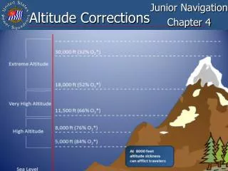
Altitude Corrections. Junior Navigation Chapter 4. Learning Objectives. Understand how the following factors affect altitude observations: Dip Refraction Parallax Semidiameter Apply altitude corrections from the Nautical Almanac to observations of the sun Celestial Tools.

E N D
Altitude Corrections Junior Navigation Chapter 4
Learning Objectives • Understand how the following factors affect altitude observations: • Dip • Refraction • Parallax • Semidiameter • Apply altitude corrections from the Nautical Almanac to observations of the sun • Celestial Tools
Comparing hs to Ho and Hc ha hs Ho or HC hs – altitude measured with sextant ha – hs corrected for ‘IE’ and ‘dip’ and used to enter Altitude Correction Tables Ho – observed altitude after corrections Hc – altitude calculated using LHA, Dec, and Latitude Apparent Position True Position True Horizontal Visible Horizon Earth Celestial Horizon 3
Sight Reduction Form LAST WEEK LAST WEEK NEXT WEEK NEXT WEEK 4
IGNORE IGNORE IGNORE IGNORE Sequence of Corrections • Record height of eye • Sextant altitude (hs) • Index correction (IC) • Dip Correction (Dip) • Apparent altitude (ha) (Used to enter altitude correction tables) • Correction from tables (Main) • Observed altitude (Ho)
Nautical Almanac Tables • Altitude Correction table for Sun, and Dip correction for a natural horizon - Appendix B • Sun table includes corrections for refraction, semidiameter, parallax, and other minor items • “Altitude Correction Table” and most of “Dip Table” are critical tables • DO NOT require interpolation • Extreme right-hand column of “Dip Table” correction (less than 8ft or greater than 70ft) • DOES require interpolation
Dip on Natural Horizon • Correction based on height of eye (HE) above water line where sight taken • For HE <8ft or >70ft <155ft use right column and interpolate • For HE between 8ft-70ft use left column and no interpolation required
Dip on Natural Horizon How to interpolate: HE is 7.5ft From table correction is 2.7 for 8ft and correction is 2.4 for 6ft Change in correction is 0.3 in 2ft Your HE from 8ft is -0.5ft 0.5ft is 25% of 2ft 25% of 0.3 is 0.077 Correction is 2.7 - 0.08 = 2.6 9
Dip on Natural Horizon How to select correction: HE is 14.6ft 14.6ft is more than 14.1ft but not more than 14.9ft so correction is 3.7 10
Dip Short (Appendix A) Sight taken with HE of 10.6 ft, across a distance of 670 yards. (Dip to NH would be -3.2’) Ds = (0.0002052 x d) + [1146 x (h/d)] Ds = (0.0002052 x 670) + [1146 x (10.6 / 670)] Ds = 0.137484 + (1146 x 0.015820896) Ds = 18.268’, rounded to 18.3’ Dip correction is -18.3’ 11
9 4 17 26 5 1 7 3 0 – 1 3 Find Ho ? ? • LL Sun sight is taken on 29 Feb. • HE = 9.4 ft NH • hs is 17° 26.5´ • IE is 1.7’ off the arc 1 7 3 0 17 25 2 13 2 17 25.2 13 2 0 0 + 13 2 17 38 4
15 13 11 9 7 5 4 3 2 1 Find Ho READY FOR YOUR ANSWERS? • UL Sun sight is taken on 25 Jun. • HE is 6.9 ft NH • IE is 3.1´ on the arc • hs is 56° 31.2´ • LL Sun sight is taken on 10 May. • HE is 5.5 ft Ds 345 yds • IE is 0.5´ off the arc • hs is 43° 50.0´ Use excerpts (Appendix B), pg 212
Find Ho UL Sun sight is taken on 25 Jun. HE is 6.9 ft NH IE is 3.1´ on the arc hs is 56° 31.2´ 0 0 5 6 – 5 6 • HE is 6.9ft • From table correction is 2.7 for 8ft and correction is 2.4 for 6ft • Change in correction is 0.3 in 2ft • Your HE from 8ft is -1.1ft • 1.1ft is 55% of 2ft • 55% of 0.3 is 0.165 • Correction is 2.7 - 0.2 = 2.5 0 0 16 5 – 16 5 6 9 56 31 2 3 1 2 5 Use excerpts (Appendix B), pg 212 56 25 6 16 5 56 09 1 14
5 5 43 50 0 0 5 18 3 - 17 8 15 0 0 0 + 15 0 Find Ho • LL Sun sight is taken on 10 May. • HE is 5.5 ft Ds 345 yds • IE is 0.5´ off the arc • hs is 43° 50.0´ 0 5 18 3 Use excerpts (Appendix B), pg 212 43 32 2 Ds = (0.0002052 x d) + [1146 x (h/d)] Ds = (0.0002052 x 345) + [1146 x (5.5 / 345)] Ds = 0.070794 + (1146 x 0.015942029) Ds = 18.34036’, rounded to 18.3’ Dip correction is -18.3’ 15 0 43 47 2
Using ‘Celestial Tools’ Although the data produced by Celestial Tools is fairly accurate, the program should not be used for navigation. Its primary purpose is instructional: to aid a student in planning sights; to allow a student to quickly check the quality of sights; and to help a student find errors in his/her work. It is not intended to do the work for the student. The Sailings – calculate, using mid-latitude or Mercator sailing, or the method used in VPP2, course and distance from initial and final positions, final position from initial position, course, and distance, and set and drift from DR position, fix position, and elapsed time. It will also calculate, using great circle sailing, initial course and distance or final position, plus maximum latitude, final course, and points on the great circle route. Sight Planner – calculate the twilight times for a selected date and location and find the azimuth, altitude, and magnitude of the visible navigational bodies at a selected time, as a list or a star chart. It will also find the times of moonrise and moonset, the phase of the Moon, and the availability of acceptable Sun-Moon fixes. Sight Reduction and Fix – completely reduce a sight to intercept and azimuth by the Law of Cosines method, allowing students to check the quality of their sights while still “at the beach”. After a minimum of two sights are reduced and saved, you have the option of establishing a fix using sights selected from the list of up to ten. LoC/NASR and Fix – allows the user to enter data from the upper part of a sight reduction form (derived from data extracted from the Nautical Almanac) and reduce the sight using the Law of Cosines and Nautical Almanac Sight Reduction methods, giving the same intermediate and final values as would be obtained with a manual reduction. TVMDC – will update the values of the compass variables (True, Variation, Magnetic, Deviation, and Compass) when any one is changed. It will also calculate the value of variation for a selected year based on the data provided on a chart. MoBoard – perform several calculations typically done on a maneuvering board, e.g. Closest Point of Approach between two moving vessels (or between a moving vessel and a stationary object), course and speed of contact vessel, true wind from apparent wind. Length of Degree – calculate the length of a degree of latitude and longitude in various linear units for both a spherical earth for a specified latitude, north or south. The WGS84 spheroid output duplicates Bowditch 2002 Table 7. Noon Sight – calculate the time of Local Apparent Noon (LAN) for a selected date and longitude, and then calculates latitude from a noon sight. It will also calculate longitude from the observed zone time for LAN. Favorite Places – save the latitudes, longitudes, range of useful azimuths, type of horizon, and dip short distance for locations that will be reused for sight-taking sessions. Automatically loads this date into the Sight Planner. Dist. by 2 Brngs – calculate the distance to a fixed object (and related quantities) by taking two bearings on the object from a moving vessel. Distances – a distance to the natural horizon calculator, a geographical range of visibility of an object calculator, and three distance by vertical angle calculators. Yellow Pages – will produce the values of the Nautical Almanac Increments and Corrections table. Sight Averaging – analyze a run of sights and calculate the average watch time and sextant altitude. CTS/SOA – calculate the “Course to Steer” and “Speed of Advance” for a course and speed affected by current. Interpolation – will do single or double interpolation, and includes a sexagesimal-to-decimal converter. 60D=ST – calculate speed, time, or distance when two of the values are known. Arc <=> Time – convert an angular value to its equivalent time and vice versa. 17
30 June 2012 1 17 0 12-58-29 Sun LL 71 44 2 0-14 39 50 6 – 1 0 12-58-15 65 21 2 4 0 3 + 1 0 4 0 15-58-15 – 3 0 30 June G 71 41 2 30 June 2012 1 17 0 o 12-58-29 Sun LL 71 44 2 g 0-14 39 50 6 15 6 – 65 21 2 G 15 6 0 0 + 15 6 71 56 8 g Using ‘Celestial Tools’ 19
17 0 71 44 2 1 0 4 0 1 0 4 0 – 3 0 71 41 2 30 June 2012 o 12-58-29 0-14 15 6 – 12-58-15 3 + 15-58-15 30 June 15 6 0 0 + 15 6 71 56 8 Using ‘Celestial Tools’ 20
Quiz 1. Dip correction is the angular difference between the visible horizon and a true horizontal. a. True b. False 21
Quiz 2. A ship's captain takes a sight from the ship's rigging with a HE of 54 feet. His mate takes a sight from the deck of the ship with a HE of 18 feet. For which HE will the dip correction be greatest? HE of 54 feet 22
Quiz 3. Find the dip correction: HECorrection 18 ft ____ 22 ft ____ 72 ft ____ - 4.1' - 4.5' - 8.2' 23
Quiz 4. For the following data, determine main sextant altitude corrections: BodyDateha Sun UL 21 June 17° 32.1' Sun LL 29 Sept 43° 46.0' Sun UL 29 Sept 43° 46.0' Sun LL 10 Mar 61° 41.6' Main -18.8' +15.0' -16.8' +15.7' 24
Next class BRING INFORMATION ON ANY SIGHTS YOU HAVE TAKEN. 25
Altitude Corrections End of Junior Navigation Chapter 4