Download
1 / 12
140 likes | 444 Views
Portal for ArcGIS. Allen County’s Experience. Dave Estes - GIS Coordinator Allen County 200 E Berry Street, Ste. 415 Fort Wayne, IN 46802 260.449.3608 dave.estes@allencounty.us. Portal for ArcGIS. What is Portal for ArcGIS? Why consider Portal for ArcGIS? How to implement Where we are…

E N D
Portal for ArcGIS Allen County’s Experience Dave Estes - GIS Coordinator Allen County 200 E Berry Street, Ste. 415 Fort Wayne, IN 46802 260.449.3608 dave.estes@allencounty.us
Portal for ArcGIS • What is Portal for ArcGIS? • Why consider Portal for ArcGIS? • How to implement • Where we are… • Where we want to go… • Demonstration(s)
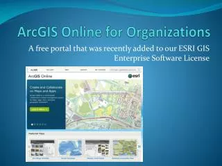
What is Portal for ArcGIS? • The ESRI Portal for ArcGIS software is the software that creates an ArcGIS Online functionality within the customer’s environment.
Why consider Portal for ArcGIS? • Share and Collaborate • Web/Mobile Device Compatibililty • Ease of use by “non-GIS” staff • Part of Allen County’s ELA
How to Implement Portal for ArcGIS • Highly recommend Portal as part of an ELA • Virtualized Server Architecture • ESRI did the actual installation* • Train departments on how to use
Where we are… We are at the beginning…
Where we are.. • ELA began in January 2013 • Server virtualization completed February 2013 • Portal for ArcGIS installed by ESRI March 2013 • GIS Visioning Workshop March 19th & 20th – Stakeholder buy-in
Where we are… • Creating basemaps and learning how to create applications • Demonstrating workflows to incorporate Portal maps into presentations and web pages
Where we want to go… • High percentage of internal departments using Portal to share data and collaborate on projects • Non-GIS staff collecting data and creating maps as part of their workflow
Where we want to go… • Implement GIS functions on mobile devices • Field Mapping • Analytics • Data collection • Create applications to serve the public
Questions? Dave Estes - GIS Coordinator Allen County 200 E Berry Street, Ste. 415 Fort Wayne, IN 46802 260.449.3608 dave.estes@allencounty.us Thank You!