Web Enabled Enterprise Integration
Web Enabled Enterprise Integration. Insert Product Photograph Here. Overview. City of Pocatello, Idaho 32 Square Miles Population of 54,255 Maintaining Water, Sewer, Storm, and Land base ~ 120 Work Orders Last Month ~2400 Permits in 2011

Web Enabled Enterprise Integration
E N D
Presentation Transcript
Web Enabled Enterprise Integration Insert Product Photograph Here
Overview • City of Pocatello, Idaho • 32 Square Miles • Population of 54,255 • Maintaining Water, Sewer, Storm, and Land base • ~120 Work Orders Last Month • ~2400 Permits in 2011 • GIS is responsible for providing data used by asset management, permitting, work orders, City staff and field crews
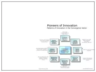
Goals • Provide an easy-to-use, easily maintained web interface to share GIS data to both internal and external users • Provide cross-departmental data in a single portal that meets City departmental needs. • Provide public access to City GIS and departmental data
We selected WebMap and why • Silverlight provided a rich, interactive user experience. (HTML5 not ready at time of development) • Provided by EMS, a company with a proven track record of working with the city. • Industry standard technology provides basis for future growth. The data backend is accessed by well defined web services.
Specifications • Software • EMS WebMap • Microsoft Silverlight 4 • C# Web Services • Lucity 7.20 Asset and Work Order Management • HTE Permitting running on AS/400
Specifications • Web Server • 2 Dual-Core 2.4 Ghz AMD Processors • 4 GB RAM • 1 TB RAID5 Local Storage • Gigabit Network Adapter • Microsoft Windows Server 2003 • IIS • Microsoft .NET Framework 4 • ArcGIS Server 10
Specifications • Database Server • 2 Dual-Core 2.4 Ghz AMD Processors • 4 GB RAM • 1 TB RAID5 Local Storage • Gigabit Network Adapter • Microsoft Windows Server 2003 • Microsoft SQL Server 2008 R2 • ArcSDE 10
Features • Custom XML configuration • GIS layers and display control • Bookmarks • Identify • Custom printing • Redline • Custom searches • Map Tips • Multimedia Support • Vehicle Routing • Relational data links
Benefits • Single application for the integration of separate data sources linked to GIS • Spatial interface used for location based workflows • No installation required, available wherever there’s an internet connection • Customizable interface • Open design allows for easy future integrations
Benefits (continued) • Do more with less – a single portal minimizes maintenance, user training, and screen space • Reduce Operating Costs • Fewer ArcMap seats needed • Users can self-serve • Smaller application footprint • Better leverage of enterprise systems • Links to visual features • Provides access to a wider user base • All data can be found in one place
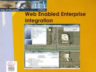
Application – Public Access • Custom branding • User configured help • Custom searches • Data blended from separate sources • Data limited for specific use • User configured printing • http://webmap.pocatello.us/public/
Application – Work Orders • Protected site • Authenticates against Lucity or the secured service • Visual display of Work Orders • Access asset management and work order data from the map • Access map from asset management software • Common shared notes
Application – Permitting • Protected site • Integrated with HTE Permitting and Inspection data • Searchable relational data • Linked to permitting reports • Custom field searches
Summary • By utilizing a centralized web-based data portal, information from various enterprise sources is viewed through a common interface via the internet. • The City saves costs on software deployment and training • The City can better respond to public and staff needs by minimizing the time needed to deploy • Available online – www.emsol.com
Future Development • HTML5, CSS3, JavaScript based application. • accessed by any device with a browser • Will run on iOS, Andriod, and Windows operating systems • GPS enabled