Download
1 / 19
190 likes | 214 Views
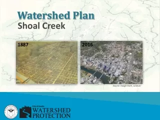
Shoal Creek. 1887. 2016. Watershed Plan. (Source: Google Earth, Landsat). Intent. Watershed Plans. Provide a user-friendly guide for each watershed that summarizes the history, natural features, development patterns, infrastructure, issues, priorities, and solutions. North Urban.

E N D
Shoal Creek 1887 2016 Watershed Plan (Source: Google Earth, Landsat)
Intent Watershed Plans Provide a user-friendly guide for each watershed that summarizes the history, natural features, development patterns, infrastructure, issues, priorities, and solutions
North Urban Watershed Plans • Shoal Creek • Waller Creek • Johnson Creek • Lady Bird Lake
Step 1: Characterize Watershed Plans • Analyze the characteristics of the watersheds. • Discuss how the existing natural features, development patterns, and infrastructure impact the types of problems and solutions. • Provide context for data relative to the rest of the watersheds citywide.
Step 1: Characterize Watershed Plans • Total Acres: 8,271 • Percent in 100-Yr Floodplain: 6% • Percent over Recharge Zone: 27% • Identified Springs: 26 • Tree Canopy Cover: 33% • Creek Health: Fair
Step 1: Characterize Watershed Plans Land Use Classifications
Step 1: Characterize Watershed Plans • Impervious Cover:53% • Treated by water quality ponds: 21% • Development built before adoption of regulations: • Drainage (1974):56% • Water Quality (1991):71% • Storm Drains built before Drainage Criteria (1978):75%
Step 2: Problems and Priorities Watershed Plans • Map and discuss the problem score data for each mission. • Provide context for the scores and priorities relative to the rest of the watersheds citywide.
Step 2: Problems and Priorities Watershed Plans • Shoal Creek has the second highest number of structures within the 100-year floodplain.
Step 2: Problems and Priorities Watershed Plans • Shoal Creek has the second highest number of total drainage complaints & the most building complaints.
Step 2: Problems and Priorities Watershed Plans • Shoal Creek has the highest number of total erosion sites, but no Type 1 sites (most severe).
Step 2: Problems and Priorities Watershed Plans • Shoal Creek has high water quality problem scores for Animal Waste and Riparian Vegetation.
Step 3: Solutions Watershed Plans • Map and discuss the past, present, and future solutions. • Describe how capital, programmatic, and regulatory solutions relate and integrate mission priorities.
Step 3: Solutions Watershed Plans • Capital projects typically design, construct, and improve infrastructure • Examples include: • Stormwater ponds for flood detention and water quality • Storm drain improvements • Stream restoration
Step 3: Solutions Watershed Plans • Programs involve ongoing and preventative activities implemented by City staff • Examples include: • Flood Early Warning System • Storm drain cleaning • Erosion repair crew • Spills response
Step 3: Solutions Watershed Plans • Regulations guide land development practices to help reduce flooding, erosion, and water pollution. • Examples include: • Erosion Hazard Zone • No adverse impact • Stormwater controls • Floodplain protection • Stream setbacks • Critical environmental features
Stay Involved & Share Your Input: • Participate in the upcoming Shoal Creek Watershed Plan process – anticipated start Fall 2016 • Attend future Forum meetings • Tuesday, March 22 – Water Quality • Tuesday, April 12 – Erosion • Tuesday, April 26 – Spring Flow • Join us for the Spring 2016 Shoal Creek Walking Tours: • Saturday, March 26 – Flooding on Shoal Creek • More info at shoalcreekconservancy.org/events