Download
1 / 53
540 likes | 803 Views
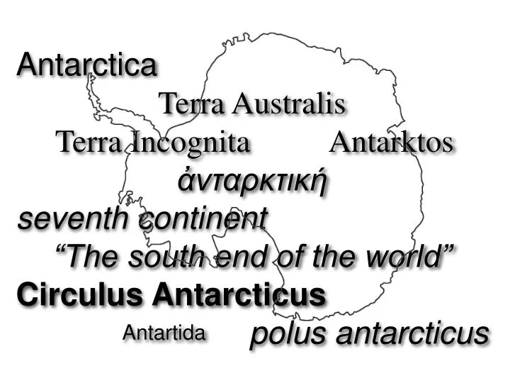
Antarctica Terra Australis Terra Incognita Antarktos ἀνταρκτική seventh continent “The south end of the world” Circulus Antarcticus polus antarcticus. Antartida. ~350 BCE

E N D
Antarctica • Terra Australis • Terra Incognita Antarktos • ἀνταρκτική • seventh continent • “The south end of the world” • Circulus Antarcticus • polus antarcticus Antartida
~350 BCE Greeks invent Antarctica ("antarktikos" meaning "opposite the arctic") to "balance" known northern land masses. 150 CE Ptolemy includes "Terra Australis" in his Geographica 1700 British Astronomer Edmund Halley captains expedition which crosses the convergence between the south Atlantic and the Southern Ocean to 52°24’S 35°W where Antarctic Tabular Ice Bergs where observed and were mistaken for islands. February 1772 French expedition led by Yves-Joseph de Kerguelen-Trémarec discovers Kerguelen Islands which becomes a base for sealers and whalers just north of the convergence in the south Indian Ocean. November 1772-March 1775 British expedition led by James Cook circumnavigates the globe at high south latitudes and enters Antarctic Circle for the first time in January 17, 1773 . Farthest south record set at 71°10’S 106°54’W (approximately 90 miles north of the Antarctic coast) February 1819 British trader William Smith discovers South Shetland Islands while sailing far south around Cape Horn. December 25, 1819 First seal hunters arrive in South Shetlands. January 1820 Edward Bransfield and William Smith chart South Shetlands. January 27, 1820 Russian expedition led by Thaddeus von Bellinghausen makes first sighting of Antarctic mainland as part of second circumnavigation of the globe at high southern latitudes (December 1819-February 1821). January 30, 1820 Bransfield and Smith sight Antarctic Peninsula south of South Shetlands. November 1820 Nathaniel Palmer sights Antarctic Peninsula south of South Shetlands. January 21, 1820 Bellinghausen expedition discovers Peter I Island. January 28, 1820 Bellinghausen expedition discovers Alexander Coast. February 7, 1821 American John Davis puts men ashore at Hughes Bay on the Antarctic Peninsula south of the South Shetlands for an hour to look for seals - first landing on continent goes unnoticed for 130 years. December 1821 British sealer George Powell discovers South Orkney Islands. February 20, 1823 British James Weddell sailing south into Weddell Sea in very mild summer looking for seals, establishes Farthest South record at 74° 15' S, 34° 16' W. December 1824 Enderby sealer Sprightly charts the north coast of the Antarctic Peninsula (Trinity Peninsula). November 1830 - April 1832 British sealer John Biscoe complete third circumnavigation of globe at high southern latitudes, dicovering Enderby Land (charting 47°20'E to Cape Ann at 51°37'E in February 1831) and exploring western coast of Antarctic Peninsula (February 1832). December 1833 British sealer Peter Kemp sights land (58°E) east of Cape Ann now known as Kemp Coast. January 1838 French expedition led by Jules Dumont d'Urville tries to follow Weddell's course south but is stopped by pack ice north of the Antarctic Circle. January - March 1839 John Bellany discovers Bellany Islands and sights Antarctic coast at approximately 119°E (Sabrina Coast). March 1839 The Flying Fish of the United States Exploring Expedition comes close to the Farthest South of James Cook (70°S 101°16’W). January 19, 1840 Expedition of Jules Durmont d'Urville sights Antarctic coast at approximately 136°E (Adélie Coast). December 1839 - March 1840 United States Exploring Expedition tracks Antarctic Coast for 1,500 miles - Wilkes Land. November 1840 - April 1841 British expedition of James Clark Ross breaks through pack ice to enter Ross Sea, dicovers Cape Adare, Admiralty Range, Ross Island, Mount Erebus, and charts the Great Ice Barrier for 300 miles. Establishes new farthest south record of 78°S. November 1841 - February 1842 Ross Expedition charts more of the Great Ice Barrier and establishes new farthest south record of 78°09'S. December 1842 - April 1843 Ross Expedition explores Weddell Sea. 1844-5 British expedition led by Thomas Moore in the ship Pagoda conducts magnetic measurements in the Southern Ocean from 0° and 100° E (primarily south of the Indian Ocean) but does not chart any additional land. 1873-74 German whaler Gronland charts parts of the Antarctic Peninsula including Bismark Strait and Wilhelm Archipelago. February 6, 1874 HMS Challenger, a British steamship, enters Antarctic Circle (a first for a steamship). Rocks dredged from the ocean floor suggest the presence of a continental land mass further south. 1892/3 Two whaling expeditions explore Antarctic Peninsula and Weddell Sea in search of Right Wales. Dundee Whaling Expedition discovers Dundee Island. Anton Carl Larsen collects fossils. 1893/4 Second visit by Anton Carl Larsen discovers Larsen Ice Shelf (on which skis used for first time), Oscar II Coast Foyn Coast and various mountains. January 19, 1895 Norwegian whaling expedition puts Hynrik Bull, Carsten Borchgrevink and four others ashore at Cape Adare. At the time, it was believed to be the first landing on Antarctica until 1952, when the 1821 landing by American sealers came to light. July 1895 Sixth International Geographical Congress proclaims that:"exploration of the Antarctic Regions is the greatest piece of geographical exploration still to be undertaken." The "Heroic Age" of Antarctic exploration begins. 1897 - 1899 Belgica Antarctic Expedition becomes trapped in ice in the Bellinghausen Sea for thirteen months and takes continuous meteorological data for an entire Antarctic year. 1898 - 1900 Southern Cross Expedition overwinters at Cape Adare, charts the Victoria Land coast, lands on the Ross Ice Shelf and sets a new Farthest South record at 78°50'S, and establishes most accurate location of the South Magnetic Pole. 1901 - 03 Gauss Expedition (First German Antarctic Expedition) explore region of coast and inland at 89°E. 1901 - 04 Discovery Expedition - based on Ross Island at western end of Ross Ice Shelf. • December 30, 1902 Scott, Shackleton and Wilson set Farthest South at 82°17'S on the Ross Ice Shelf (the "Great Ice Barrier"). 1901 - 04 Swedish Antarctic Expedition explorers northwest coast of Antarctic Peninsula. Unplanned overwintering caused by inability of ship to pick up expedition. Ship is crushed in ice and lost and three separate parties overwinter and are rescued in late 1903. 1903 - 04 Scotish National Antarctic Expedition discovers Coats Land on eastern side of the Weddell Sea and establishes first permanent weather station in Antarctic on South Orkney Islands which is given over to Argentina. 1904 - 05 Third French Antarctic Expedition explores west coast of Antarctic Peninsula. 1907 - 09 Nimrod Expedition - based on Ross Island at western end of Ross Ice Shelf. • March 10, 1908 - five members of the expedition reach summit of Mount Erebus; • January 9, 1909 - Earnest Shackleton and four others reach 88°23'S an new Farthest South just 111 statute miles from the South Pole; • January 17, 1909 - Edgeworth David, Alistair Mackay, and Douglas Mawson reach south magnetic pole. 1908 - 10 Fourth French Antarctic Expedition returns to same region of Third French Antarctic Expedition and discovers Charcot Land and follows sea ice off coast west for 600 miles. 1910 - 12 Japanese Antarctic Expedition - explores Ross Ice Shelf south of the Bay of Whales and explores Edward VII Land. 1911 - 13 Second German Antarctic Expedition. 1910 - 12 Amundsen South Pole Expedition - based at the Bay of Whales on the eastern side of the Ross Ice Shelf. • December 14-17, 1911, Amundsen, Bjaaland, Hanssen, Hassel and Wisting at South Pole. 1910 - 11 Terra Nova Expedition - based on Ross Island at western end of Ross Ice Shelf. • January 17-18, 1912 Scott, Henry Robertson Bowers, Evans, Oates, and Wilson reach South Pole; • February-March, 1912 on return journey. 1911 - 14 Australasian Antarctic expedition. 1914 - 16 Shackleton's failed Imperial Transantarctic Expedition (Endurance Expedition). 1928 • November 16, Hurbert Wilkins and Carl Ben Eielson make first aircraft flight over Antarctica; • December 20, Wilkins and Eielson make extended flight over the Antarctic Pensinsula. 1929 • January 15, Richard Byrd, Bernt Balchen and Harold June fly east from Bay of Whales, discover Rockefeller Mountains; • November 29 Byrd, Balchen, June, and Ashley McKinley fly over South Pole and photograph about 150,000 square miles of Antarctica; • Wilkins conducts flights over Charcot Land; • Douglas Mawson and Hjalmar Riiser-Larsen begin expeditions along coast of [East Antarctica]]. 1930 January 14, Mawson and Risser-Larsen met off of Cape Ann (51oE) - 45oE becomes demarcation between British/Australian/New Zealand area (45oE - 160oE) and Norwegian area (10oE-45oE). 1930s Whaling ships begin using aircraft to spot whales and contibute to exploration of Antarctic Coast. 1933 - 5 Second Byrd Expedition conducts extensive aerial exploration of Ross Ice Shelf, King Edward VII. Land and Marie Byrd Land. 1934 - 7 British Graham Land Expedition. November 23 - December 5, 1935 Lincoln Ellsworth and Herbert Hollick-Kenyon fly from Dundee Island off the nothern tip of the Antarctic Peninsula to Bay of Whales on the Ross Ice Shelf - discovering Ellsworth Mountains and Ellsworth Land. 1939 - 40 Third Byrd Expedition - United States Antarctic Service Expedition. 1946 – 47 Fourth Byrd Expedition - Operation High Jump. 1947 - 8 Ronne Antarctic Research Expedition - operating in Weddell Sea, explores Ronne Ice shelf. 1949 - 52 Norwegian-British-Swedish Antarctic Expedition. 1955 – 56 Fifth Byrd Expedition - Operation Deep Freeze. • October 32, 1956 - George Dufek lands aircraft at South Pole to establish permanent Amundsen-Scott South Pole Station. 1957 - 8 International Geophysical Year leads to establishment on numerous temporary and permanent Antarctic research stations by many nations. 1959 Antarctic Treaty System signed commiting signers to peaceful scientific activity and limiting military activity to support of peaceful endeavors such as science. Chronology of Antarctic Exploration Chronology of Antarctic Exploration Chronology of Antarctic Exploration Chronology of Antarctic Exploration http://www.eoearth.org/article/Chronology_of_Antarctic_Exploration
Claudius Ptolemy (c.100-178) He introduced mathematics to map making • Ptolemy’ World Map c.150 AD (republished 1482). Ptolemy (c.100-178) was a hugely important geographer and astronomer working in Ancient Rome. This map takes valuable information from his famous book Geographia. His work informed mapmakers on the size of the Earth, and the co-ordinates for the positions of all the places and features indicated on the map. http://www.bl.uk/learning/artimages/maphist/minds/ptolemysmap/ptolemy.html
Ptolemy map info • Why is this map entitled Ptolemy’s world map, when it was made more than 1000 years after Ptolemy’s death? • Ptolemy (c.100-178) was a hugely important geographer and astronomer working in Ancient Rome. This map takes valuable information from his famous book Geographia. His work informed mapmakers on the size of the Earth, and the co-ordinates for the positions of all the places and features indicated on the map. • Until a copy of Geographia was translated from Greek into Latin in 1407, all knowledge of these co-ordinates had been lost in the West. The book created a sensation, as it challenged the very basis of medieval mapmaking – mapmakers before this had based the proportions of countries, not on mathematical calculations, but on the importance of different places - the more important a country was, the bigger it appeared on the map. In fact, many of Ptolemy’s calculations were later proved to be incorrect. However, the introduction of mathematics and the idea of accurate measurement were to change the nature of European mapmaking forever.
16th century • Gerardus Mercator (1512-1594) http://digitalgallery.nypl.org/nypldigital/id?1524650
16th century • Petrus Plancius • 1594 Orbis Terrarum Typus De Integro Multis In Locis Emendatus auctore Petro Plancio 1594 http://www.raremaps.com/
17th century • America, nouiter delineata. • Additional Name(s) • : Merian, Matthaeus, 1593-1650 -- Publisher • Published Date • : [1634] http://digitalgallery.nypl.org/nypldigital/id?434546
17th century • Edmund Halley (1656-1742) Ships: Paramore in 1699-1700 • Geomagnetism http://www.ieeeghn.org/wiki/index.php/Geomagnetism_and_Edmond_Halley_%281656-1742%29
17th century • Edmund Halley (1656-1742) Ships: Paramore in 1699-1700 • Geomagnetism http://www.ieeeghn.org/wiki/index.php/Geomagnetism_and_Edmond_Halley_%281656-1742%29
18th century • Captain James Cook (1728-1779) • Circumnavigation of Antarctica on the ships, the Resolution and the Adventure in 1772-1775.
19th century • IV: JOHN GEORGE (1860 – 1920) Geographer and Cartographer Royal, LLD, FRSE, RGS Victoria Medal, RSGS Hon. Sec. (1884-1920) • John George joined his father in the early 1880s while studying at Edinburgh University, succeeding him in 1888 (age 28), when the business was moved to shared premises in partnership with Thomas Nelson at Park Road. He named his office “The Edinburgh Geographical Institute”, and shaped the future of the firm with foresight and boldness. He issued a wide range of unique and remarkable productions, and the business prospered with its rising status. John George’s sense of colour harmony was appreciated in the innovative layer colouring of the Reduced O.S. Half-Inch Map of Great Britain, and by the scientific works which he produced in collaboration with academic colleagues: The Survey Atlas of Scotland (1895), Geological Map of Scotland (1893), Physical Atlas: Meteorology (1899), Zoogeography (1911), Bathymetrical Survey of Scottish Fresh-Water Lochs (1907) and Chronological Map of Edinburgh (1919). http://www.timesatlas.com/Heritage/Pages/home.aspx?RT=Bartholomew
19th century • Captain James Weddell, (1787-1834). • Voyage in 1822-1824. February 20, 1823 British James Weddell sailing south into Weddell Sea in very mild summer looking for seals, establishes Farthest South record at 74° 15' S, 34° 16' W
19th century • Captain James Clark Ross, (1800-1862) • Ships: H.M.S. Erebus & the H.M.S. Terror, 1839-1843.
19th century • Captain Thaddeus von Bellinghausen (1778-1852) • Ships: Vostok (East) & Mirnyi (Peaceful), 1819-1821.
19th century • Captain J.S. Dumont D’Urville (1790-1842) • Ships:Astrolabe and the Zélée
19th century • Charles Wilkes, (1798-1877)commander of the United States Exploring Expedition 1838-42 The Vincennes, flagship of the United States Exploring Expedition 1838-42. http://www.eoearth.org/article/United_States_Exploring_Expedition
19th century • Charles Wilkes, (1798-1877)commander of the United States Exploring Expedition 1838-42 The Vincennes, flagship of the United States Exploring Expedition 1838-42. http://www.eoearth.org/article/United_States_Exploring_Expedition
19th century • Nathaniel Palmer (1799-1877), an American seaman Ship: 47 ft. sloop, Hero in 1820. • During a voyage to the South Atlantic in 1820-21, Nathaniel, captain of the 47-foot sloop Hero, pressed southward in search of new seal rookeries. On November 17, 1820 he sighted "land not yet laid down on my chart." He had discovered a place which would later become known as Palmer Land on the continent of Antarctica. http://www.stoningtonhistory.org/palmer2.htm
Expeditions of the Heroic Age of Antarctic Exploration, 1897–1922 • July 1895 • Sixth International Geographical Congress proclaims that:"exploration of the Antarctic Regions is the greatest piece of geographical exploration still to be undertaken." The "Heroic Age" of Antarctic exploration begins. http://www.eoearth.org/article/Chronology_of_Antarctic_Exploration
The Heroic Age • Adrienne de Gerlache, 1866-1934. • Belgica Antarctic Expedition (1897-1899) http://www.coolantarctica.com/Antarctica%20fact%20file/History/antarctic_whos_who_belgica.htm http://www.eoearth.org/article/The_%22Heroic_Age%22_of_Antarctic_Exploration
20th century • Captain R.F. Scott (1868-1912) • Ship: Discovery, 1901-1904. http://www.flickr.com/photos/scottamundsenrace/sets/72157625271187511/
20th century • Jean-Baptiste Charcot (1867-1937) • Ship: Porquoi-pas?, 1908-1910 http://loc.gov/pictures/resource/ggbain.04801/
20th century • Roald Amundsen (1872-1928) Norwegian • 1st to reach the geographic South Pole on Dec. 14, 1911. • Ship: Fram, 1910-1912 http://www.coolantarctica.com/Antarctica%20fact%20file/History/roald%20amundsen.htm
20th century • Roald Amundsen (1872-1928) Norwegian • 1st to reach the geographic South Pole on Dec. 14, 1911. • Ship: Fram, 1910-1912 http://www.coolantarctica.com/Antarctica%20fact%20file/History/roald%20amundsen.htm
20th century • Captain R.F. Scott (1868-1912) • Ship: Terra Nova, 1910-1913. http://www.flickr.com/photos/scottamundsenrace/sets/72157625271187511/
20th century • Captain R.F. Scott (1868-1912) • Ship: Terra Nova, 1910-1913. http://www.flickr.com/photos/scottamundsenrace/sets/72157625271187511/
20th century • Thomas Griffith Taylor (1880-1963). Geologist. • He was the physiographer on Scott’s 1910-13 expedition. He led the western journey party into Victoria Land. • Taylor Glacier Dry Valley was named for him by R.F. Scott http://trove.nla.gov.au/people/1265174?q=taylor%2C+thomas+griffith&l-availability=y&c=people
20th century • Sir Ernest Shackleton (1874-1922) • Ship: Nimrod, 1907-09 • Sir Douglas Mawson was on this expedition http://www.shackletoncentenary.org/about/the-original-nimrod-expedition.php http://www.jamescairdsociety.com/shackleton-news.php?id=102344
20th century • Explorers Alistair McKay, Edgeworth David and Douglas Mawson around flag planted at Magnetic South Pole, Antarctica. January 17, 1909 - Edgeworth David, Alistair Mackay, and Douglas Mawson reach south magnetic pole. http://www.slv.vic.gov.au/ergo/douglas_mawson
20th century • Sir Douglas Mawson (1882-1958) • Ship: Discovery, 1929-1931. http://www.travel-antarctica.com
20th century • Sir Ernest Shackleton (1874-1922) • Ship: Endurance, 1914-1916. http://www.jamescairdsociety.com/shackleton-news.php?id=102449
20th century Sir Ernest Shackleton (1874-1922) Ship: Endurance, 1914-1916. http://www.jamescairdsociety.com/shackleton-news.php?id=102449
20th century Sir Ernest Shackleton (1874-1922) Ship: Endurance, 1914-1916. http://www.jamescairdsociety.com/shackleton-news.php?id=102449
20th century • November 16, 1928 • Hurbert Wilkins & Carl Ben Eielson make first aircraft flight over Antarctica. Eielson Wilkins http://www.south-pole.com/p0000106.htm
20th century • Richard Evelyn Byrd (1888-1957) • 1928-1930 expedition http://ngm.nationalgeographic.com/ngm/0312/feature1/online_extra1/zoom5.html http://video.nationalgeographic.com/video/player/places/regions-places/polar-regions/antarctica_byrdexpedition.html
20th century • Richard Evelyn Byrd (1888-1957) • The first to make polar exploration by plane including the first to circle the South Pole. • 1928-1930 expedition http://ngm.nationalgeographic.com/ngm/0312/feature1/online_extra1/zoom5.html http://video.nationalgeographic.com/video/player/places/regions-places/polar-regions/antarctica_byrdexpedition.html
20th century • Lincoln Ellsworth (1880-1951) • Transantarctic flight from his ship, the Wyatt Earp. • Success on 3rd attempt. • 1933-34, 1934-35, 1935-1936. http://www.south-pole.com/map.htm http://library.osu.edu/sites/exhibits/nautilus/idea.html
20th century • 1947 - 8 • Ronne Antarctic Research Expedition - operating in Weddell Sea, explores Ronne Ice shelf.
History of the International Polar Year • http://ipy.arcticportal.org/about-ipy • International Polar Year 2008 - 2009 1st International Polar Year (1882-1883) 2nd International Polar Year (1932-1933) The International Geophysical Year (1957-1958) http://ipy.arcticportal.org/about-ipy/ipy-history
International Geophysical Year and the Antarctic Treaty System • 1957 - 8 International Geophysical Year leads to establishment on numerous temporary and permanent Antarctic research stations by many nations. • 1959 • Antarctic Treaty System signed commiting signers to peaceful scientific activity and limiting military activity to support of peaceful endeavors such as science. http://www.eoearth.org/article/Antarctica_and_the_International_Geophysical_Year
International Geophysical Year and the Antarctic Treaty System • 1957 - 8 International Geophysical Year leads to establishment on numerous temporary and permanent Antarctic research stations by many nations. • 1959 • Antarctic Treaty System signed commiting signers to peaceful scientific activity and limiting military activity to support of peaceful endeavors such as science. Jun 1958 - President Eisenhower's Proposals for Antarctic Treaty. - II-Nation Acceptance of International Conference on Antarctica. The U.S. Government sent Notes on May 3 to all countries participating in the International Geophysical. Year programme in Antarctica proposing the conclusion of a treaty which would have the following objects: • "(1) Freedom of scientific investigation throughout Antarctica by citizens, organizations, and Governments of all countries, and a continuation of the international scientific co-operation which is being carried out so successfully during the current International Geophysical Year. • "(2) International agreement to ensure that Antarctica is used for peaceful purposes only. • "(3) Any other peaceful purposes not inconsistent with the Charter of the United Nations." Keesing's Record of World Events (formerly Keesing's Contemporary Archives), Volume XI, June, 1958 International, Page 16234 http://www.eoearth.org/article/Antarctica_and_the_International_Geophysical_Year
International Geophysical Year and the Antarctic Treaty System • Amundsen-Scott South Pole Station (U.S., 1956) • Almirante Brown Antarctic Base (Argentina, 1951), • Byrd Station (U.S., 1957 ), • Casey Station (Australia, 1959), • Davis Station (Australia, 1957), • Dumont d'Urville Station (France, 1956), • Halley Research Station (U.K., 1956), • Jubany Scientific Station (Argentina, 1953), • Mawson Station (Australia, 1954), • McMurdo Station (U.S., 1956 - near the location of Scott's base camp), • Mirny Station (Russia, formerly U.S.S.R., 1956), • San Martín Station (Argentina, 1951), • Scott Base (New Zealand, 1957), • Showa Station (Japan, 1958), • Wilkes Station (U.S. - now abandoned), and • Vostok Station (Russia, formerly U.S.S.R., 1957). http://www.eoearth.org/article/Antarctica_and_the_International_Geophysical_Year
Women in Antarctica http://www.wingsworldquest.org/ • http://news.nationalgeographic.com/news/2000/11/1115_antarctica.html http://www.exploratorium.edu/origins/antarctica/people/women.html n 1935, Caroline Mikkelsen, wife of a Norwegian whaling captain, became the first known woman to set foot, briefly, in Antarctica http://www.livescience.com/8685-female-polar-explorers-revisit-tragic-race-south-pole.html http://www.ronneantarcticexplorers.com/ronne_antarctic_research_expedition.htm http://yourexpedition.com/bae/ American Ann Bancroft and Norwegian Liv Arnesen
Geology,etc • http://www.loc.gov/today/placesinthenews/archive/2007arch/20070205_antarctica.html • Antarctic Region, 2005 • Antarctica, the fifth-largest continent in the world, is slightly larger than 1.5 times the size of the United States. It covers an estimated area of 14 million sq. km., of which 280,000 sq. km. is ice-free and 13.72 million sq. km. is ice-covered. • For more information on Antarctica, see these sites: NOAA and NSIDC.
Geology, Climate, etc. Antarctica is divided in two by the Transantaractic Mountains • West Antarctica • East Antarctica - higher elevation, colder temps. A joint effort of the USGS National Mapping Division and the National Science Foundation United States Antarctic Program. The U.S. Antarctic Resource Center (USARC) is located at the U.S. Geological Survey (USGS) in Reston , Va. It maintains the nation's most comprehensive collection of Antarctic aerial photography, maps, charts, satellite imagery and technical reports. The USARC collection includes materials produced by the following Antarctic Treaty nations: Argentina, Australia, Belgium, Brazil, Chile, China, Ecuador, Finland, France, Germany, India, Italy, Japan, the Republic of Korea, the Netherlands, New Zealand, Norway, Peru, Poland, the Russian Federation, South Africa, Spain, Sweden, the United Kingdom, the United States, and Uruguay. The USARC is the United States contribution to the SCAR Library system and is managed through an interagency agreement with the National Science Foundation which provides support to the USGS for scientific activities in Antarctic and in support of the U.S. Antarctic Program. http://gisdata.usgs.gov/website/antarctic_research_atlas/ United States Antarctic Resource Center http://usarc.usgs.gov/ http://lima.usgs.gov/download.php
South Pole Transantarctic Mountains