Download
1 / 28
300 likes | 504 Views
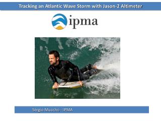
Jason-2 Altimeter Calibration Status Quo Walter Hausleitner, Jörg Weingrill Altimeter Calibration Workshop 2010 Graz, Austria. Transponder Experiments. Transponder site on Gavdos, Greece Jason-2 calibration –present status. problems. Transponder site. Transponder instrument.

E N D
Jason-2 Altimeter Calibration Status Quo Walter Hausleitner, Jörg Weingrill Altimeter Calibration Workshop 2010 Graz, Austria IWF/ÖAW GRAZ
Transponder Experiments • Transponder site on Gavdos, Greece • Jason-2 calibration –present status problems IWF/ÖAW GRAZ
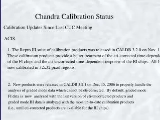
Transponder site IWF/ÖAW GRAZ
Transponder instrument • Frequency / Bandwidth • Centre Frequ. 13.7 GHz • Bandwidth: 600 MHz • Total gain: 77 dB • Intrument delay: 13.25 ns IWF/ÖAW GRAZ
Ocean vs. point target response IWF/ÖAW GRAZ
Point target response IWF/ÖAW GRAZ
Calibration data availability 2009 IWF/ÖAW GRAZ
Calibration data availability 2010 IWF/ÖAW GRAZ
Data processing concept S-IGDR Calibration Data S-IGDR data extraction Fit parabola to echo bins Reproduce obs. corr. Compute absolute times Combine S-IGDR+Calibr. Interp. TRP meas. corr. Atmospheric Corr. Geometric Corr. Geophysical Corr. Precise range residual IWF/ÖAW GRAZ
S-IGDR • Sensor Interim Geophysical Data Records (S-IGDRR) • NetCDF Files from podaac.jpl.nasa.gov • 1 Hz data + 20 Hz high-rate data • Waveforms • Latency: 2 days • Pass 018 • Descending Gavdos pass Pass 018 IWF/ÖAW GRAZ
S-IGDRRm data records used lat lat_20hz lon lon_20hz range_ku range_20hz_ku rad_wet_tropo_corr model_dry_tropo_corr iono_corr_alt_ku sea_state_bias_ku model_wet_tropo_corr alt alt_20hz mean_sea_surface solid_earth_tide pole_tide inv_bar_corr hf_fluctuations_corr net_instr_corr_range_ku S-IGDR IWF/ÖAW GRAZ
Jason-2 Calibration • S-IGDR error budget From Jason-2 Products Handbook IWF/ÖAW GRAZ
Calibration analysis concept • Computation of closest approach time from S-IGDR orbit • Identification of TRP echo bin for each elementary waveform • Parabola fit and determination of vertex • Tie vertex of parabola to closest orbit point for aligning the calibrations to the orbit • Derive absolute times for each TRP echo bin through the relative times given calibration interval and bin-size 3 sec calibrationwaveforms 11 sec data gap IWF/ÖAW GRAZ
S-IGDR data interpolation IWF/ÖAW GRAZ
Poseidon-2 elementary calibration IWF/ÖAW GRAZ
TRP echo bin detection • Lagrange interpolation of TRP power response • Numerical differentiation and Gaussian curve fitting • Power dependent weighting for each bin IWF/ÖAW GRAZ
Closest approach time/distance • Parabola fitting through TRP echo bins • Determination of fractional calibration number at parabola vertex • Aligning vertex with absolute time of closest approach IWF/ÖAW GRAZ
Altimeter range command NSPEC * 0.05100769 3.125 ns IWF/ÖAW GRAZ
Ambiguity of cal range • Altimeter range command 34 km • Ambiguity = (18/PRF)*c/2 • PRF = 2058.513239 Hz • 1310 km Ambiguity + Calibration range 1344 km IWF/ÖAW GRAZ
Altitude vs. Ku-band range IWF/ÖAW GRAZ
Propagation and reflection effects IWF/ÖAW GRAZ
Corrected range -2.55 m IWF/ÖAW GRAZ
Sea surface height IWF/ÖAW GRAZ
Geophysical corrections Mean sea surface Solid Earth tide Geocentr. Ocean tide Pole tide height Inv. barom. height eff. HF fluctuations of SST IWF/ÖAW GRAZ
Geophysical corrections (cont’d) IWF/ÖAW GRAZ
There is a significant difference between either interpolating the individual corrections and sum up the interpolated corrections Summing up the corrections and interpolate the sum of corrections Interpolation effects IWF/ÖAW GRAZ
Signal runtime corrections GPS Transponder/Altimetry Center of mass correctionAltimeter instrument delay Dry troposphereWet troposphereIonosphere r hS Transponder delayOffset station markerSlant range correction hT SST Solid Earth tidesPole tides Geoid href Ellipsoid IWF/ÖAW GRAZ
TRP range residuals Calibration bin rangeAmbiguityAltimeter delayCoM Correction 33738.0881310718.858-5.173 0.471 r -2.297-0.116-0.016 Dry troposphereWet (water vapour)Ionosphere TRP delay (electronic)TRP delay (geometric)Station marker eccentricitySlant range correction - 3.972 -1.477 -0.824 TRP ell.heightSolid earth tides 251.169 -0.0601344398.967 44.575 Geoid ? Ellipsoid Orbital heightResidual IWF/ÖAW GRAZ