Cascade Volcanic Arc - Eruptive History and Hazards Monitoring Strategies
390 likes | 484 Views
Delve into the eruptive history and potential hazards of the Cascade Volcanic Arc, exploring monitoring and mitigation strategies used by experts to safeguard against volcanic impacts. From lahars to tephra fall, understand the risks and implications for proximal areas and aviation safety. Learn about the ongoing monitoring efforts and the importance of preparation and risk assessment in volcanic zones.

Cascade Volcanic Arc - Eruptive History and Hazards Monitoring Strategies
E N D
Presentation Transcript
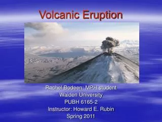
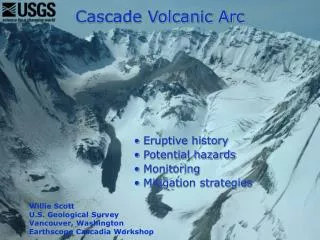
Cascade Volcanic Arc Eruptive history Potential hazards Monitoring Mitigation strategies Willie Scott U.S. Geological Survey Vancouver, Washington Earthscope Cascadia Workshop
40 million year history of subduction tectonics, magmatism, and volcanism • Isn’t going to stop anytime soon
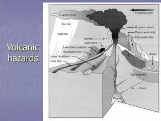
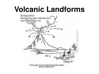
Volcano Hazards • Proximal areas (up to 25 km or 15 miles) subject to multiple hazards; some rapid • Lahars and floods affect valleys for tens of kilometers • Tephra fall affects areas tens to hundreds of kilometers, or more, downwind • Excess sediment in watersheds makes channels unstable for years to decades
Lahars • Erosion • Burial • Impact • Altered channels Montserrat Volcano Observatory
Sediment impacts on river channels can last for decades US Army Corps of Engineers US Army Corps of Engineers US Army Corps of Engineers
Far-traveledtephra hazards • Loads structures • Reduces visibility • Abrasive and conductive • Health risks • Large areas; long duration • Danger to aircraft
Impacts of volcanicash fallsversus thickness Less than 1 mm Irritant to lungs and eyes Airports and air traffic closed Road visibility and traction affected 1-5 mm Initial crop damage Electrical shorts and equipment damage Clogged sewage systems
Impacts of volcanic ash falls 5-100 mm • Burial of forage and low crops • Major urban ash removal
Impacts of volcanic ash falls 100-300 mm • Some roof collapse if ash wet • Severe damage to trees • Many power lines down • >300 mm • Heavy kill of vegetation, livestock, and aquatic life • Major roof collapse • Loading and breakage of large power lines • Roads impassable
Tephra Hazards to Aviation Mount Etna-2002 Internationalcooperation
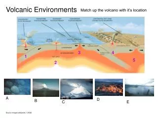
13 major centers in U.S. • Long lived • Recurrently active • Episodic at several time scales
Mitigating Volcanic Risk • Assess hazards (scientists) • Monitor potentially hazardous volcanoes (scientists) • Prepare appropriate land-use and emergency-response plans (public officials, interagency groups) • Prepare site-specific plans (public and private sector)
p (1800 AD) (1505 AD ~1575 AD, (1480 AD) (~800 AD) (~0 AD) Reconstructing eruptive history and long-term hazard assessment • Geologic mapping • Stratigraphic studies • Origin and extent
What’s at risk? Residents per square kilometer 0-1 1-10 11-100 101-1000 1001-10,000
Surface deformation Volcano monitoring • Intrusion of magma causes pressurization by: • Increasing volume • Heating of ground water • Release of gas • Results in: • Earthquakes • Ground deformation • Emission of CO2 and S • gases Input of mafic magma
Co-Located CGPS and Seismometer Xmit antennas GPS antenna Solar panels Seismic electronics, radio, batteries To seismometer GPS electronics, radio, batteries
Three Sisters, Oregon Ongoing crustal uplift 1997-?Revealed by InSAR Interferometric Synthetic Aperture Radar
ContinuousGPS mm 20 N 0 -20 E 20 0 -20 U 80 0 Mean rates: North 10.7 mm/yr East -3.1 mm/yr Vertical 22.6 mm/yr -80 2001 2002 2003 2004 2005
Geodetic campaigns GPS Tilt-leveling
Airborne Gas Monitoring MSH Gas emissions in tons/day CO2 300-2000 SO2 30-250 H2S 0-5 Figure from Ken McGee
Mount St. Helens seismicity, 1980-2004 Episodic magma recharge? 1980-1986 eruption Steam and ash emissions
9/23 9/24,10 am IS 9/25 9/26, 3 pm AL1 9/27 9/28 In the beginning….. Shallow/low-energy seismic swarm similar to many past ones; interpreted to be the result of prior month’s high rainfall
Unrest, Eruption, Alert Levels tremor explosion AL 3 Volcano Alert (Warning) AL 2 Volcano Advisory (Watch) AL 1 Notice of Volcanic Unrest • IC Team activated • Close cooperation among GPNF, WA-EMD, USGS
Growth of welt; explosions 29 Sep 2004 01 Oct 2004 06 Oct 2004 02 Oct 2004
Transition to steady-state lava-dome growth • Few ≤M0 per minute • ~M1 every minute or two • Several ~M2 per day • Slowed during summer 2005
Repetitive “drumbeat” earthquakes, > 1 million to date Pacific Northwest Seismograph Network
Mount St. Helens, 2005 Mont Pelée, 1902≤300-m vertical spine ~400-m “recumbent spine”…. 15 March 2005 • Gouge cover • Grooves and striae
Dome 5 grows; breaks up; dome 6 begins westward movement and 5 sags down and west 4 5 3 1 2 Sept 2005 13 July 2005 5 4 6 Domes 2 and 1 now buried in talus 3
Bezymianny Volcano, Kamchatka 50 yr after MSH-1980-type eruption 30 May 2006 Mount St. Helens renewed lava-dome growth; October 2004 to ????