Download
1 / 32
330 likes | 357 Views
Learn how to implement the Marine Data Model for sediment and coastline studies using DHI software and GIS integration. This presentation covers importing survey data, associating transects, building profiles, and analyzing sediment transport.

E N D
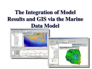
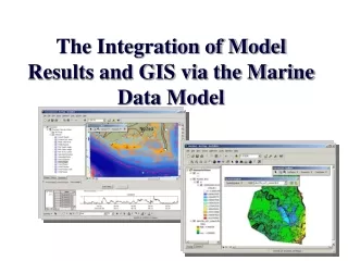
The Integration of Model Results and GIS via the Marine Data Model
Michael J. Blongewicz GIS Specialist DHI Water & Environment Portland, Oregon mjb@dhi.us www.dhi.dk www.dhisoftware.com
Introduction DHI Water & Environment Modeling Software Water Resources - MIKE 11, MIKE SHE, MIKE Basin Marine - LITPACK, MIKE 21, MIKE 3 Urban - MIKE Urban
DHI Water & Environment GIS Perspective: Integrating Hydrological, Marine and Urban numeric modeling within GIS
DHI Software Integrating Modeling within GIS • I Data Integration • Geodatabase • Marine Data Model • DHI Marine Data Model • II Application Integration • ArcGIS Development • MIKE Objects • MIKE Marine GIS • TimeSeries Manager • III Model Execution • FloodWatch (M11) • MIKE Basin • MIKE Flood • IV Model Results • Rendering dfs2 • Line series • Deriving time series from rasters • Animations
Water Resources Data Model Urban Marine DHI Software Model Integration at the Data Level DHI GIS Software DHI Numeric Models
Data Models This presentation has 2 intentions 1. To introduce or review the Marine Data Model and illustrate how it can be implemented for one use-case. 2. To show how it can be extended or customized to meet specific needs
DHI Marine Software with the Marine Data Model Case Study Sediment Budget and Coastline Evolution Bathymetric Surveys (FeatureClass: Survey Point) Sediment Surveys (FeatureClass: Survey Point) Transects Line Series (FeatureClass: Dataline) Cross-shore distribution of sediment transport Feature / Time Series Association Marine Features (FeatureClass: TimeSeries Point) Time Series (ObjectClass: TimeSeries)
DHI Marine Software with the Marine Data Model Sediment Budget and Coastline Evolution Import XYZ bathymetry survey data and soil survey into the geodatabase
Marine Data Model FeatureClass: Survey PointDHI_SurveyPoint ObjectClass: SurveyInfo SedimentInfo
Marine Data Model FeatureClass:Survey Point ObjectClass: SurveyInfo
DHI Marine Software with the Marine Data Model Sediment Budget and Coastline Evolution Add other data types: (bathymetries, satellite images, etc.)
DHI Marine Software with the Marine Data Model Sediment Budget and Coastline Evolution Add Transects (DataLines)
DHI Marine Software with the Marine Data Model Sediment Budget and Coastline Evolution Associate Transects with a Survey
Marine Data Model FeatureClass: DataLine FeatureClass: DHI_Transect ObjectClass: SurveyKeyInfo ObjectClass: SuveryInfo
Marine Data Model FeatureClass: DataLines FeatureClass: DHI_Transects
DHI Marine Software with the Marine Data Model Sediment Budget and Coastline Evolution Build profiles (stored as events) from Transects
Marine Data Model FeatureClass: DataLine FeatureClass: DHI_Transect ObjectClass: DHI_TransectsPoints
DHI Marine Software with the Marine Data Model Sediment Budget and Coastline Evolution Collect time series for deep sea location and making an association to a feature
Marine Data Model FeatureClass: TimeSeriesPoint ObjectClass: Measurement
Marine Data Model FeatureClass: TimeSeriesPoint ObjectClass: Measurement
DHI Marine Software with the Marine Data Model Sediment Budget and Coastline Evolution Build Wave Climate (Wave Direction, Wave Period and Wave Height)
DHI Marine Software with the Marine Data Model Sediment Budget and Coastline Evolution Transfer Wave Climate from Deep Sea Point to Near Shore Points (FeatureClass: TimeSeriesPoint)
DHI Marine Software with the Marine Data Model Sediment Budget and Coastline Evolution View wave height from a 2-Dimensional model as a raster
DHI Marine Software with the Marine Data Model Sediment Budget and Coastline Evolution View wave height from a 2-Dimensional model as a mesh
Marine Data Model FeatureClass: MeshElements FeatureClass: MeshPoint ObjectClass: VectorQuantities ObjectClass ScalarQuantities
DHI Marine Software with the Marine Data Model Sediment Budget and Coastline Evolution Export Transect as a dfs1 for input to LITPACK (numeric modeling software) along with the wave climate, sediment survey to calculate the Sediment Transport along the Transect
DHI Marine Software with the Marine Data Model Sediment Budget and Coastline Evolution Import 1-Dimensional result data into geodatabase as Events along the Transect
Marine Data Model FeatureClass: DataLine FeatureClass: DHI_Transect ObjectClass: DHI_TransectsPoints
DHI Marine Software with the Marine Data Model Sediment Budget and Coastline Evolution Generate profile of Sediment Transport