Download
1 / 17
170 likes | 295 Views
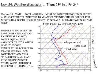
Nov. 24: Weather discussion …Thurs 23 rd into Fri 24 th. Thu Nov 23 12GMT… OVER ALBERTA... MOST OF RGN ENTRENCHED IN ARCTIC AIRMASS WITH FNT EXPECTED TO MEANDER VICINITY THE US BORDER FOR NEXT 36 HRS. DEPTH OF COLD AIR OVR CENTRAL ALBERTA BETWEEN 850 AND 700MB.

E N D
Nov. 24: Weather discussion …Thurs 23rd into Fri 24th Thu Nov 23 12GMT… OVER ALBERTA... MOST OF RGN ENTRENCHED IN ARCTIC AIRMASS WITH FNT EXPECTED TO MEANDER VICINITY THE US BORDER FOR NEXT 36 HRS. DEPTH OF COLD AIR OVR CENTRAL ALBERTA BETWEEN 850 AND 700MB. Stony Plain 12Z Thurs 23 Nov. 2006 MODELS FCSTG INVERTED TROF OVER CENTRAL AND EASTERN AREAS WITH WATER EQUIVALENT AMOUNTS OF 5 TO 8 WHICH GIVEN THE COLD TEMPERATURES OUGHT TO TRANSLATE TO 8-12 CM WORTH OF SNOW. THIS SEEMS REASONABLE AND CONSIDERING WINTER STORM WATCH FOR RGNS JUST EAST OF EDMNONTON. • deep saturated stable layer • wind shear
Max available 0.2 – 0.4 inches water 0.5 – 1 cm water Snow equivalent is 10-15 times deeper, so (taking 15x) we could get a max of 15 cm or (taking 10x) a min of 5 cm (… this assumes 100% conversion to snow on ground) 12Z Thurs 23 Nov.
Thu Nov 23 19Z 2006 GMT.. SNOW FALLING ACROSS CENTRAL ALBERTA COURTESY OF AN UPPER LOW WITH LOTS OF INSTABILITY**. AMOUNTS SO FAR SEEM TO BE IN THE 4 TO 8 CM RANGE ALTHOUGH AS THE SYSTEM MOVES NORTH AND UPPER LOW DEVELOPS, THE SPEED OF THE SYSTEM WILL DIMINISH AND LARGER AMOUNTS ARE EXPECTED. SO FAR SEEMS TO BE A 15 TO 1 SWE. GEM 36 hr prog from 12Z Wed giving 12 hr cumulative precip (mm water equiv). Thus GEM predicted about 1-3 mm SWE (snow water equivalent) ie. 1.5-4.5 cm snow for 05-17 MST Thurs ** let’s see what this refers to…
x by 15 to convert to snow: 1.5 cm … seems too low
on first sight, we noted the deep saturated stable layer • so where’s the “lots of instability”? Stony Plain 12Z Thurs 23 Nov. 2006 This little nose of colder air above ground? Note lapse rate is (roughly) dry adiabatic in thin layer on ground…
Peaks about 3 km ASL Kelowna (B.C.) inversion
3 hr fcst valid 15Z Thurs giving fcst snow accumulation for 12Z Thurs - 15Z Thurs Did not predict snow for Edmonton http://www.weather.unisys.com/nam/winter.html 12 hr fcst valid 00Z Friday giving fcst snow accumulation for 21Z Thurs - 00Z Fri [ x by 2.5 to get cm] (Edmonton in the 0.5 – 1 inch band, ie. about 1-3 cm)
48 hr prog from 12Z Tues CMC 500 mb analysis 12Z Thurs 23 Nov. 2006 24 hr prog from 12Z Wed • 24 hr prog excellent • 48 hr prog v.g. too
GOES seeing high (cold) cloud tops in Ab. • red arrows show wind above 500 mb level (where it was more southerly than at 500 mb – see sounding) • upper wind orientation backing to S through morning • Edmonton thickness 522 dam GOES satellite winds 12Z Thurs 23 Nov. GOES satellite winds 18Z Thurs 23 Nov. CMC 500 mb analysis 12Z Thurs 23 Nov. 2006 400 – 100 mb level 700 – 400 mb level 1000 – 700 mb level
CMC 850 mb analysis 12Z Thurs 23 Nov. 2006 • strong T-gradient against mountains
CMC sfc analysis 12Z Fri 24 Nov. • sfc ridge through C. Ab., p rising • sfc temps rather uniform • mid morning, only partial cover of light cloud • windy – trees moving, snow blowing off rooves • reasonably strong sfc p-gradient
CMC 850 mb analysis 12Z Fri 24 Nov. • deep inversion • baroclinic zone remains against mntns
GEM 0hr prog valid 12Z Fri CMC 500 mb analysis 12Z Fri 24 Nov. • closed upper low (meriodional flow) • main stream far to south • setting is a broad longwave trough over W North Am. • cold thickness advection • erroneous wind direction! • Edmonton thickness 510 dam (down 12 dam = 6 degrees since 12Z Thurs)
Edmonton thickness 494 dam • ie. 8 degrees colder yet GEM 48hr prog valid 12Z Sunday
Extended forecasts for Sunday Monday and Tuesday for central and northern Alberta issued by Environment Canada at 10.30 AM MST Friday 24 November 2006. City of Edmonton… Sunday..Cloudy with 60 percent chance of flurries. Low minus 28. High minus 24. Monday..Cloudy with 60 percent chance of flurries. Low minus 26. High minus 24. Tuesday..Sunny. Low minus 27. High minus 21. Normals for the period..Low minus 13. High minus 3.