Download
1 / 4
40 likes | 68 Views
This race takes you through the beautiful Silksworth Complex and along the scenic Sunderland coastline, passing landmarks like the lighthouse and Roker Pier. Enjoy stunning views and challenging terrain. Don't forget to stop at CP1 and CP4 for checkpoints!

E N D
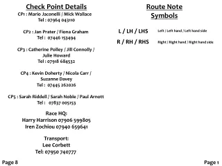
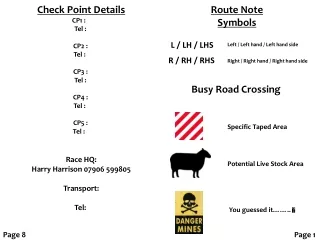
Check Point Details CP1 : Tel : CP2 : Tel : CP3 : Tel : CP4 : Tel : CP5 : Tel : Race HQ: Harry Harrison 07906 599805 Transport: Tel: Route Note Symbols L / LH / LHS Left / Left hand / Left hand side R / RH / RHS Right / Right hand / Right hand side Busy Road Crossing Specific Taped Area Potential Live Stock Area You guessed it…….. Page 8 Page 1
START - CP 1 Approx. 6.8 miles Silksworth Complex CP 5 - FINISH Approx. 4.2 miles (37 miles) Ashbrooke Sports Ground Head SW on Ashbrooke Road and enter Backhouse park on LHS. Take Main path and continue into park. At junction turn R and head up steps. At top turn L and follow path to park gates. Exit park, cross Ryhope Road and head down Villette Road. After 450m turn R into Corporation Road, then turn L into St Cecilia's Close, at road end cross car park then cross Commercial Road, follow Promenade through tunnel and down to Hendon Promenade. Stay on prom for 500m then take path to R up bank, taking L fork when path splits. Continue along cliff top path, then take path parallel to the railway line. After approx 2 km turn R up path under road and railway. Continue up to main road and turn R, follow road past The Albion, cross Ryhope Road and take track on LHS signed Silksworth / City Centre. Follow path, cross road bridge and continue past boxing club on RHS. After passing old pit wheel on path signposted Silksworth take path to RHS heading up towards housing. Follow path alongside fence then down steps to rejoin tarmac path. Turn R uphill, as path turns to right take grass path heading for the wooded area. At entry to woods follow path uphill until emerging in old quarry area. Follow path around edge of quarry then turn R up to old sports pitches, follow path along LHS of sports pitches through 2 gaps in trees and up to trig point. Turn L and head down narrow path around front of cliff face, on reaching road turn L along road, after LH bend in 100m take path to R around field edge, after 150m take path to L through trees to follow path alongside Tunstall Hope Road. As path turns left head straight up embankment onto disused railway line. Turn R and follow line, cross Durham Terrace and Silksworth Lane to enter Silksworth Complex. Follow path, take L fork and arrive at CP1, Sunderland parkrun Start/Finish. Head out along the pier to the lighthouse, make a note of the inscription on the foundation stone, turn about and re-trace your steps to CP5. Turn L and head along the prom towards the yacht club. Pass around the LHS and follow the path around the marina past the RNLI station. At the next corner head up the road towards the garage, take the path to the LHS and head downhill towards the National Glass Centre. Follow the quayside past the glass centre and university buildings. Immediately prior to the Wear Bridge turn R and take the steps up to the bridge. Turn L and cross the bridge, take the subway to cross under the road, turn R and up the steps back to road level. Proceed through the city centre and then up Burdon Road past the Civic Centre on your RHS. At the second set of traffic lights turn R in to The Cloisters then L into Ashbrooke Road. Follow the road around and re-enter Ashbrooke Sports Club, removing muddy shoes at the door go down the corridor and take the stairs on the RHS down to the Ditchburn Room. HONK THE STROLLER HORN TO STOP THE CLOCK. Page 2 Page 7
CP 4 - CP 5 Approx. 7 miles (32.8 miles) Roker Pier CP1 - CP 2 Approx. 6 miles ( 12.8 miles) Cox Green Leave CP4 and continue along Bede's Way over stile past farm. At the end of the track follow path to R, over stile and uphill alongside field. At the top of the bank turn L along path all the way to Cleadon Tower. Continue past Tower along path keeping to the RHS. Continue to golf course and cross keeping to the marked path. After leaving the golf course turn R and follow path parallel to wall, follow track behind houses and continue down to Lizard Lane. Cross road and follow path down alongside caravan park, before reaching Coast Road turn R and follow path in front of Marsden Kilns before crossing road before the field North of Souter Lighthouse. Head diagonally across field to follow path beside the Eastern wall of the lighthouse. Cross short piece of open grass to pick up coastal path. Follow path past nature reserve and behind former ranges and Whitburn Primary School. On reaching Latimers Fish Shop, follow road for 20m before taking path to L down to beach then back up to path behind Fishermen's Cottages. Follow Seaburn Prom until reaching the Marriott Hotel on LHS. Follow prom around to Cat & Dog steps and drop onto beach. Continue around headland before turning R to rejoin prom. Follow prom to the Western End of Roker Pier – CP5. From CP head towards ski lodge but immediately take grass path to RHS to skirt around the bank above running track. As path drops turn R down steep bank to cross path, up opposite bank and head towards metal gate in LH corner of Complex. Follow Princetown Terrace to end, turn R then L to traffic lights. Cross Durham Road and head up Grindon Lane. After roundabout in about 50m turn L into Barnes Park Extension. Follow path, taking R fork, cross Gravesend Road and continue up hill and down other side. At bottom take path to RHS, through field and up towards farm buildings. On reaching track turn L, after 100m take path to R over stile and up to trig point. Descend hill to farm track then onto Foxcover Lane. Turn R and cross A19 bridge. Cross barrier to LHS and head downhill for 100m, take R path into woods. At end of woods head through gap in trees take LH path, cross tarmac path and follow grass path uphill. Head to rock on top of hill, then directly West to stones on second hill. Continue over hill, down to shale path, turn R, then take L fork away from lake. Cross bridge and continue straight up path to top corner of park, turn R and head for park entrance/exit. Cross Chester Road at roundabout, through kissing gate and up path to Penshaw Monument. Take path to rear and descend via steps, through gate, turn R. After 70m cross stile to LHS and down field, cross still and continue down to road. Cross road, after 30m cross stile on RHS, follow path across field, over stile and turn R down path until reaching main road. Turn L and continue down to river, CP2 on your LHS in car park. Page 6 Page 3
CP 2 - CP 3 Approx. 6.3 miles (19.1 miles) Hylton Castle CP 3 - CP 4 Approx. 6.7 miles (25.8 miles) Hawthorn Village Leave CP, head to bridge and cross River Wear. Take R fork, then R fork again to follow path along North side of river. Follow path as it heads away from river and skirts around industrial units. Cross open ground and pass entrance to Washington Wildfowl Trust. Take path in RH corner of car park. Continue along path, ignore left turn and follow path until it returns to the riverside. Follow path until it heads uphill to reach the A19, cross under bridge and take steps to LHS onto footpath alongside A19. Cross River Wear and take path to LHS. On reaching Offerton Lane turn L and head down to riverside. At Golden Lion cross car park to LHS and follow riverside path. Where path forks take L fork and continue past Boat Club (river side). Continue across open ground before taking path directly through sandstone cliffs to RHS, continue until reaching Metro line then turning L. Follow path alongside Metro line until reaching Northern Spire access roundabout, follow road down to bridge and cross River Wear. Cross Wessington Way at traffic lights, head into Castletown Dene through gap in fence in North West corner of the junction. Follow path alongside Wessington Way before dropping down to R and crossing Castletown Road, skirt around North side of lake. Continue along path until trees clear on RHS, turn immediately R up steep grass bank to reach path, turn L. Follow path and head directly for Hylton Castle – CP3. Leave CP and turn R on Craigavon Road to traffic lights. Cross Washington Road and head straight up grass path, at the top of the bank turn L and follow the path behind Bunny Hill Walk In Centre onto Kidderminster Road, turn L to Hylton Lane, turn R and head uphill. Shortly after leaving Sunderland take path on R through stile. Follow path across the top of Downhill Complex, after passing first building on RHS keep left along path adjacent to farmers field. Cross large open grass field and head along the R side of the all weather court to join tarmac path. Take L fork and follow track ignoring any paths to the right. After approx 200m at LH bend leave road and carry straight on along path. Follow path around the outer fence of Redhill Academy. As path heads along behind housing take L fork and pass behind retirement home, just before the path reaches the road turn L and follow path around to the L. At RH corner turn R up through gap in trees to enter Fulwell Quarry. Follow the path to the L before turning R into the main centre of the quarry. Follow the path around to the L, leaving the quarry in an Easterly direction. As the ground rises take the R fork to turn onto a path running adjacent to trees and bushes. Follow this path past the football pitch and the Sunderland WW1 Accoustic Mirror. Continue downhill past the allotments before emerging onto Newcastle Road. Turn L towards the roundabout before taking Shields Road to the R. Immediately after passing the last house on the RHS cross the stile on the R, follow track along field behind houses before crossing to the LH corner and passing through the stile. Cross over the bridge to the L and turn R to follow the path until it meets Moor Lane. Turn R and follow the road, turn L into Sandy Chare, R into North Guards then L into Wellands Lane. Continue until signpost for Bede's Way on LHS, arrive at CP4 – Wellhouse Farm. Page 4 Page 5