Download

1 / 55
550 likes | 563 Views
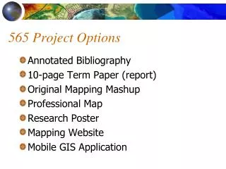
GEO 565 Options. Option 1 - Annotated Bibliography uploaded to the web Option 2 - Term Paper Option 3 – Original Mapping Mashup and Report uploaded to the web Choose which option you want by Tue., January 18th Options 1 and 2 due by 5:00, Fri., March 11th NO EXTENSIONS!.

E N D
GEO 565 Options • Option 1 - Annotated Bibliography uploaded to the web • Option 2 - Term Paper • Option 3 – Original Mapping Mashup and Report uploaded to the web • Choose which option you want by Tue., January 18th • Options 1 and 2 due by 5:00, Fri., March 11th • NO EXTENSIONS!
GEO 565 Annotated Bibliography (Option 1) • MUST be web-based • Don’t know HTML? Don’t panic! Resources will be available - it’s easy! • Upload your page(s) by Friday, March 11th, 5:00 p.m. • See dusk.geo.orst.edu/gis/projects.html
GEO 565 Term Paper (Option 2) • 20 pages (double-spaced) INCLUDING figures and references • MS-word doc sent by email preferred • flexible on subject matter of paper • specify and follow a scholarly journal format!! • specify key words • points will be subtracted if these specifications are omitted
Suggested Term Paper Content • look at current uses of GIS in your area of interest … or related fields • identify potential for furthering research • research/management questions • describe a study in progress (proposal?)
GEO 565 Project (Option 3) • Original mapping mashup integrating at least THREE data sets and/or data services • MUST have prior GIS experience (GIS/cartography course, job, internship) • MUST submit a proposal by Jan. 18th • Must STILL complete Labs 1-6 • Detailed instructions and examples at dusk.geo.orst.edu/gis/projects.html • Mashup + full documentation • Due 4:00 p.m., Mar. 16th - NO final exam
What is GIS?What is GIScience? Longley et al., GI Systems & Science, VR 100 Preface, Chapter 1 Place Matters…, VR 102
Some Basic GIS Concepts... • Mapping is key but is NOT the whole story. • A GIS is NOT simply for MAKING maps • maps at different scales, projections, colors • … not simply for STORING maps or images. • In fact, it stores the DATA from which these are created.
An Analysis Tool... • for every piece of data it specifies: • what it is • where it is • how it relates to other pieces of data • things in common • see spatial relationships or create NEW relationships
Geographic Information System • Container of data • Container of maps • Inventory of geographically distributed features and facilities • Computerized tool to automate time-consuming tasks • Analysis tools for solving geographic problems • Spatial decision support system • Method for revealing patterns and processes in geographic information
Software People Data Network Procedures Hardware Geographic Information System • Organized collection of • Software • Hardware • Network • Data • People • Procedures
Major Questions for a GIS: • What exists at a certain location? • Where are certain conditions satisfied? • What has changed in a place over time? • What spatial patterns exist? • What if this condition occurred at this place? (modelling, hypothesis testing)
For example... Toxic Substance Locations: District 24 District 16 14 George Boulevard Proposed School Locations: 124 Elm Street 35 White Road
School Locations Toxic Substances
Information on the World • How it looks – Form or Pattern • How it works – Process • Knowledge about process more valuable than form, because can be used to predict • GIS combine • General scientific knowledge in software • Specific information in databases
Major Questions for YOU... • What ARE my questions? • How much data do I need and of what quality? • How can I combine my data to answer my questions?
The Process of GIS (i.e., GIScience) • Think about a place or a topic ... • Ask a question about it ... • Analyze data to make a map ... • Explore the patterns that appear ... • Enhance the data or modify the analysis ... • Ask a new question … • Repeat ...
Defining GIS • Different definitions of a GIS have evolved in different areas and disciplines. • map coordinates, • Database of spatial and often non-spatial, • computer-based link between them. • All GIS definitions recognize that spatial data are unique because they are linked to maps.
Spatial/Geospatial/Geographic Data? • Latitude and longitude • Street address • x and y coordinates • Range and township • Location shown on a map
Non-spatial Data? • Name • Gender • Income • SSN or student ID number • Political party
Attributes in a Database • Attribute data are stored logically in flat files. • i.e., matrix of numbers and values stored in rows and columns, like a spreadsheet.
The Data Model • A conceptual description (mental model) of how spatial data are organized for use by the GIS • GISs have traditionally used either “field”or“object”data models
Grid extent Grid cell s w o R Resolution Columns A Field Data Model Uses a Raster or Grid Data Structure.
“Rasters are Faster...” • maps directly onto computer memory structure (array). • easy to understand, read, write, draw
Rasters are Faster... • natural for scanned or remotely sensed data. • continuous surfaces (e.g., topography) • spatial analytical operations are faster. • compression is easier “Rasters tell WHAT occurs everywhere.”
“ Rasters are Faster, but Vectors are Correcter! ” • Can represent point, line, and area features more accurately. • Far more efficient than grids. • Not where EVERYTHING occurs (continuous phenomena)… • But WHAT occurs everywhere … • Work well with GPS receivers.
Object/Vector Feature Types Feature Type Single Part Multi-Part Point Line Area Annotation H I G 10 H W Y A
3 Distinguishing Characteristics of a GIS vs. Other Systems • provides links between points, lines, areas, grids and their ATTRIBUTES in a database
2. provides algorithms for ANALYSIS of spatial data
3. “spatially intelligent” - “thinks” points, lines, areas, grids are actual spots on Earth’s surface - e.g., switching projections, computing distances
GIS is a multi-Billion dollar business. • annual software revenues top $1 billion, increasing ~14% yearly • ESRI and Intergraph software revenues account for 1/2 of industry total • GIS industry now at $7 BILLION
Open Source GISquantum GIS - qgis.orguDIG - uDIG.refractions.netGRASS - grass.itc.it
GIS as an approach to science Geographic Information Science is research both on and with GIS. “the generic issues that surround the use of GIS technology, impede its successful implementation, or emerge from an understanding of its potential capabilities.” (Goodchild, 1992)
“GISci” “GIScience” “GIS & T” • Geographic information science • U.S., geography, UCGIS • to GIS as statistics is to the statistical packages • The science behind the systems • Fundamental issues arising from use • The science that is done with the technology • Systematic study of geographic information using scientific methods
GISystems Remote Sensing Cartography Surveying (Geomatics) Geodesy (GPS) Landscape Ecology Statistics Mathematics Computer Science Information Science Operations Research Management Science Psychology, Sociology More … GIScience - Contributing Disciplines
GIS, GIScience, GIS & T • GISystems (GIS) • Emphasis on technology and tools • GIScience (GISci) • Fundamental issues raised by the use of GIS and related technologies (e.g.) • Spatial analysis • Map projections • Accuracy • Scientific visualization • GIScience & Technology (GIS & T)
Major Journals/Trade Mags. • International Journal of Geographical Information Science • Cartography and Geographic Information Science • Transactions in GIS • GEOInformatics • GEOConnexion • ArcUser
Regular GISci Scholarly Papers • Photogrammetric Engineering and Remote Sensing • Annals of the Association of American Geographers • Cartographica • Computers, Environment, and Urban Systems • Computers and Geosciences • IEEE Transactions on Computer Graphics and Applications • International Journal of Remote Sensing
Occasional GISci Scholarly Papers • Landscape Ecology • Bulletin of the Ecological Society of America • Geochemistry, Geophysics, Geosystems • Geojournal • Many more …
National Professional Organizations AAG: The Association of American Geographers. GITA: Geospatial Information & Technology Assoc. (formerly AM/FM) URISA: Urban and Regional InformationSystems Association. ACSM: American Congress on Surveying and Mapping. ASPRS: American Society for Photogrammetry and Remote Sensing. UCGIS: University Consortium for Geographic Information Science