Download
1 / 23
230 likes | 341 Views
Delve into the geological wonders of central Montana, including the Red Rocks Fault, U-shaped valleys, and Horn Mount Powell cirques. Discover the fascinating topography of the region through this informative map analysis.

E N D
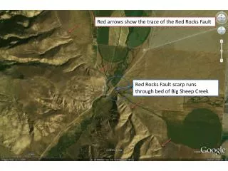
Red arrows show the trace of the Red Rocks Fault Red Rocks Fault scarp runs through bed of Big Sheep Creek
Tarns Aretes U-shaped valleys
McDonald, C., Lopez, D.A., Berg, R.B., Gibson, R.I., 2005, Preliminary geologic map of the Ringling 30' x 60' quadrangle, central Montana, Montana Bureau of Mines and Geology: Open-File Report 511, 1 sheet(s), 1:100,000. http://www.mbmg.mtech.edu/mbmgcat/public/ListCitation.asp?pub_id=11709&
Wise River Braided flood plain
Big Hole River Town of Melrose
Tailings pond Tailings dam Continental Pit Continental Pit Berkeley Pit East Ridge Continental Fault Continental Fault
arêtes horn Mill Creek glacial valley Mount Hagan tarns cirques U-shaped valleys
tarns Horn Mount Powell cirque U-shaped valleys
Many beach line traces Clark Fork River Missoula
Clark Fork River Bitterroot River
Cedar creek Fan outline
This oxbow meander will be cut off during a future flood. Flood plain Oxbow lake, or billabong as they are called in Australia.
Goodrich Gulch alluvial fan Fault scarp Goodrich Gulch
Arcuate slump scarps Slumped masses – note bulges at toes of slumps
Head scarp Slumped mass Toe bulge
Berg, R.B., Lopez, D.A., 2000, Geologic map of the Livingston 30' x 60' quadrangle, south-central Montana, Montana Bureau of Mines and Geology: Open-File Report 406, 1 sheet(s), 1:100,000.
McCartney Mountain granite Folded bedrock Big Hole River Notch Bottom
Kleinschmidt Flats alluvial fan North Fork Blackfoot River Kleinschmidt Lake potholes Browns Lake
cirques Red Mountain Stonewall Mountain arete U-shaped valley
Grant Horse Prairie Creek flood plain Barrett Creek alluvial fan