Download
1 / 1
20 likes | 160 Views
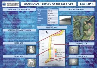
GROUP 6. GEOPHYSICAL SURVEY OF THE FAL RIVER. INTRODUCTION + METHODS. SITE BACKGROUND. The aim of this investigation was to gain an understanding of the habitats on the river bed using side scan sonar and ground truthing using an underwater video camera.

E N D
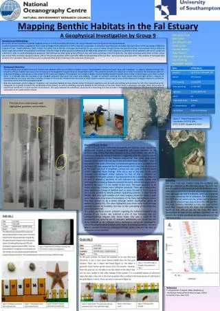
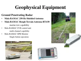
GROUP 6 GEOPHYSICAL SURVEY OF THE FAL RIVER INTRODUCTION + METHODS SITE BACKGROUND The aim of this investigation was to gain an understanding of the habitats on the river bed using side scan sonar and ground truthing using an underwater video camera. An understanding of the river bed substrates and habitats will enable us to recognise ways in which impacts of human activity can be managed. It will also increase our understanding of possible impacts of climate change. Using a sidescan tow fish, the route along the river was surveyed. This provided backscatter information allowing the sea floor substrate and habitats to be predicted. Ground truthing was then carried out at 4 stations along the route using an underwater drop camera. This allowed us to test the accuracy of the backscatter data and gain an idea of the river bed ecology. In this investigation, side-scan sonar was used to image the topography of the river bed. The sound waves are transmitted from a tow fish which is towed beneath the surface from a vessel. The soundwaves are fan shaped acoustic pulses that travel outwards from the tow fish to the river bed. Some of the sound energy is reflected as back scatter back towards the tow fish. The towfish we were using had a slant range of 75m, a swath width of 150m and ran at 100 kHz. A time series is created from the time taken for the pulse to return and the sound wave amplitude. This enables 150m of riverbed imagery to be captured as a long continuous image as the fish is towed by the vessel (starfishsonar.com). A simple underwater video camera system was deployed into the water to a depth just above the sea floor, and then left to drift, filming images of the river bed. These were recorded onto a DVD so that species could be later identified. It was also used to order to ground truth the data from the sidescan sonar and to see how well they correlated. Figure… above illustrated the location at which the drop camera entered the water. The Fal Estuary was selected for habitat mapping as it is a Special Area of Conservation (SAC) and is therefore recognised as a location where habitat types and species considered to be most in need of conservation are found (www.defra.gov.uk). Maerl beds are an important habitat within this area of conservation as well as oysters, which are the last of the wild oyster beds to be found in Cornwall. It is also worth noting that mussel farms are located along the River Fal. HABITAT MAP SIDESCAN SONAR OVERVIEW The sidescan taken along the transect in the Fal river shows fairly homogenous conditions throughout. The majority of sediment seen is silt and mud, which can be recognised on the sidescan due to the paler grey colour, and on the habitat map as yellow. There are however small differences in tone along the sides of the scan, which represent changes of and on the riverbed. The mussel farm can be identified on the left hand side of the scan and is surrounded by fine sediments that have been observed on the video to be barren with limited epifauna. On the habitat map it is the blue area. Rocky outcrops are also present at points on the right hand side of the scan as they are seen as darker patches which indicate harder substrate, and as orange on the map. Large cargo ships were moored in the river, and they can be identified on the scan as there is no shadow and are superimposed. There are areas of sand ripples which occasionally span out from the bank, and were observed as the grains are coarser. Finally, large patches of algae and shell debris are found along the river bed, especially further up river, which has been demonstrated on the map in red. The sidescan was also used to identify areas of interest where videos could be recorded. VIDEO SITE 1 VIDEO SITE 3 The video at station 1 was taken the nearest to the riverine end member of the estuary however the location was still tidally dominated. At this location a lot of leaf litter and dead shells were observed. Under this was a homogenous muddy substrate. Here Palmaria palmata was observed, attached to rocky outcrops or shell remnants. On other stones and rocks the Rhodophycae Grateloupia filicina was commonly found. From the shell debris, dead Ostrea edulis (right) could only be easily identified without physical sampling. Worm tubes were also common on the rocks and shells that were visible; these were from the tubeworm, Filagrana implexa. Station 3 was just upstream of the mussel farm and it was very barren, with only the homogenous muds visible. This is most likely due to the station being near to the jetty where the ferry to Truro moors. The leaf litter and shells that would be expected here are most likely to have been scattered by ferry propellers. A lone Pagorus was the only species seen, mostly likely the common hermit crab as the front claws looked disproportionate but it was very tough to see with the blurred footage (left). Tubeworm burrows were constructed within the soft substrate but no organisms were actually seen. VIDEO SITE 2 VIDEO SITE 4 At station 4, below the mussel farm and away from a jetty, the leaf litter and dead shells were found once again, With 3 hermit crabs seen fighting within one frame (left). Filagrana implexa, Palmaria palamata and Grateloupia filicina were also common at this site. The sponge Verongia aerophoba was also seen for the first time on a camera drop along with the bonny sponge, Cliona celata. Station 2 was also tidally dominated and nearer the end of our river transect. Similar species were observed here from station 1. Such as Filagrana implexa on the shells and rocks, Palmaria palmata and Grateloupia filicina being the dominant macroalgae and a lot of leaf litter and dead shells. A single Coryphoblenneus galerita was spotted sheltering between the leaf litter and shells (see photo). A hermit crab was also spotted but could not be fully identifited beyond Pagorus. The dragonet, Callionymus lyra was also seen near an anemone, Haliplanella lineata. A very well camoflaged Eutrigula gurnardus, the Grey Gurnard was spotted along with a juvenile Sea Bream, Pagellus bogaraveo (right).