Download
1 / 1
10 likes | 151 Views
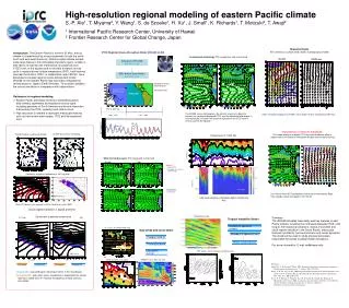
Orography & surface wind (Jan). COADS annual-mean climatology. iROAM cloudiness (radiatively defined). IPRC Regional Ocean-Atmosphere Model ( iROAM ) on ES. Cloud regime transition in space and time. Gap winds and ocean dome. Cloud water & potential temperature. 15 S, Sept. 95W.

E N D
Orography & surface wind (Jan) COADS annual-mean climatology iROAM cloudiness (radiatively defined) IPRC Regional Ocean-Atmosphere Model (iROAM) on ES Cloud regime transition in space and time Gap winds and ocean dome Cloud water & potential temperature 15 S, Sept 95W Atmosphere: IPRC-RAM 0.5°×0.5°, L 28 Papagayo wind jet mid-tropospheric cooling Thermocline dome GFDL Modular Ocean Model 2 0.5°×0.5°, L 35 Cool spot in summer Atmosphere forced by NCEP reanalysis land surface model Cloud water & potential temperature at 10S, Aug-Sept Temp at z=0 & 45 m (July) TRMM Precip & SST (Jul-Oct) Costa Rica Dome SST cooling Longitude Time Decoupled Coupled ABL Coupled ABL Decoupled Coupled run SST-forced run Coupled ABL: over cold water, cloud layer forms in the mixed layer Decoupled ABL: over warm water, cloud base is separated from mixed layer by a stable layer moisture transport by shallow cumulus convection. Ocean spin-up Seasonal Cycle SST (contours), surface wind vectors & precip (gray shade) Warm SST biases in the coupled run lift the cloud base east of 100W 1990 – 1995 1996 – 2003 Introduction. The Eastern Pacific is home to El Nino, and its climate is characterized by strong asymmetry in both the north-south and east-west directions. Global coupled climate models suffer large biases in this climatically important region, notably in their failure to maintain the intertropical convergence zone (ITCZ) north of the equator and to simulate a realistic annual cycle in equatorial sea surface temperature (SST), both features important for El Nino. IPRC, in collaboration with FRCGC, have developed a coupled regional ocean-atmosphere model (ROAM) for the eastern Pacific that have been integrated for several years on Japan’s Earth Simulator. This poster highlights the control simulation in comparison with observations. Annual-mean climatology: SST, precipitation and surface wind IROAM TRMM obs 25 25 Ocean forced by NCEP reanalysis iROAM Obs: CMAP, OISST & QSCAT Interactive The iROAM successfully captures the climatic asymmetry about the equator (the northward-displaced ITCZ), and the equatorial cold tongue. It also realistically simulates the seasonal migration of the ITCZ and the annual cycle on the equator. • Rationales for regional modeling • Eastern Pacific processes are key to establishing basin-wide climatic asymmetry and equatorial annual cycle, including geometry of South America and air-sea interaction that involves the ITCZ, upwelling and stratus cloud. • High resolution is needed to represent mesoscale features such as narrow mountain ranges, ITCZ and the equatorial front. ITCZ’s meridional migration (125-95W), with a double ITCZ for a brief period of Mar-Apr) Obs Spin up Importance of internal feedback: The model produces a double ITCZ when cloud-radiative effect is suppressed in the Southern Hemisphere despite realistic lateral forcing iROAM Temperature at 110W, EQ Warm and cold seasons: SST, precip and surface wind Obs iROAM • March • Double ITCZ • Orographic effect on the northern ITCZ Depth (m) iROAM • September • Cold tongue Left: Annual-mean SST, precipitation and surface wind velocity. Right: Time-latitude section averaged in 120-100oW. Depth (m) TAO obs Little annual variations in thermocline depth in contrast to El Nino iROAM SST at 2N Tropical Instability Waves Instability of equatorial currents Meanders of equatorial front Wind & cloud response SST (color), scalar (contour) and vector wind High-resolution regional modeling of eastern Pacific climate S.-P. Xie1, T. Miyama2, Y. Wang1, S. de Szoeke1, H. Xu1, J. Small1, K. Richards1, T. Motizuki2, T. Awaji2 1 International Pacific Research Center, University of Hawaii 2 Frontier Research Center for Global Change, Japan Summary The iROAM simulates reasonably well key features of east Pacific climate, including the northward-displaced ITCZ, cold tongue, their seasonal variations, stratus cloud deck and cloud regime transition in the South Pacific, mesoscale features included by narrow mountains and ocean dynamics. The model will be used to study physical processes responsible for biases of global model simulations. For more information, E-mail xie@hawaii.edu References Small, R.J., S.-P. Xie and Y. Wang, 2003: Numerical simulation of atmospheric response to Pacific tropical instability waves. J. Climate, 16, 3722-3740. Wang, Y., H. Xu, and S.-P. Xie, 2004: Regional model simulations of marine boundary layer clouds over the Southeast Pacific off South America. Part II: Sensitivity experiments. Mon. Wea. Rev., 132, 2650–2668. Xie, S.-P., T. Miyama, Y. Wang, H. Xu, S.P. de Szoeke, R.J. Small, K.J. Richards, T. Mochizuki, and T. Awaji, 2006: A regional ocean-atmosphere model for eastern Pacific climate: Towards reducing tropical biases. J. Climate, submitted. http://iprc.soest.hawaii.edu/~xie/roam.pdf