Download
1 / 18
180 likes | 287 Views
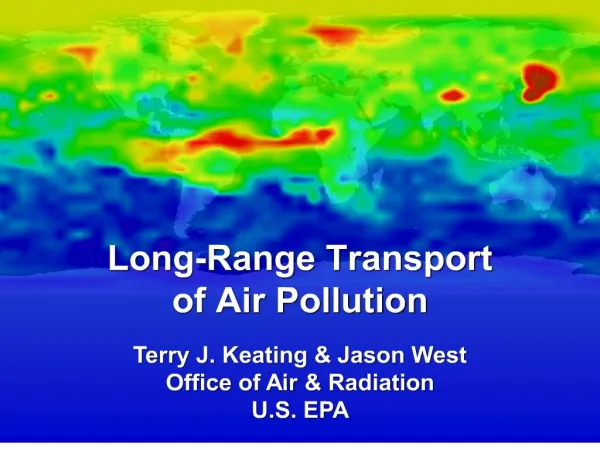
Georeferencing Water Quality Assessments to NHDPlus Catchments A New Approach to Evaluating and Measuring Progress in Surface Water Quality. Dwane Young, U.S. EPA, Office of Water. Outline. Georeferencing Pilot ( GeoPilot ) Background and Goals Methods in Brief Results

E N D
Georeferencing Water Quality Assessments to NHDPlus Catchments A New Approach to Evaluating and Measuring Progress in Surface Water Quality Dwane Young, U.S. EPA, Office of Water
Outline • Georeferencing Pilot (GeoPilot) • Background and Goals • Methods in Brief • Results • Using Catchment-Based Indexing to Measure Progress • Benefits • Examples U.S. EPA
Clean Water Act • Section 303(d) • A List of Impaired Waters for which a TMDL still needs to be completed • Section 305(b) • An Assessment of the Water Quality of all navigable waters in each State • Integrated Report (IR) • Integrates data from Sections 303(d) and 305(b) U.S. EPA
Background • States submit IR/303(d)/305(b) decision data and the corresponding location information to EPA • Geospatial data are different formats • Resolutions • Medium Resolution: 1:100,000 scale • High Resolution: mixture of scales, typically 1:24,000 or better • Reference layers • NHD/NHDPlus • Other than NHD • Current processing is mostly manual • Time consuming • Expensive to EPA GeoPilot initiated to investigate and test potential improvements U.S. EPA
Goals of Georeferencing Pilot • Reduce cost through automated processing • Process and publish geospatial data faster • Maintain high data quality • Create more complete dataset U.S. EPA
Catchment-Based Indexing • Used NHDPlus Version 2 Catchments • Approximately 2.6 million catchments in contiguous US • Average size: 1.1 square miles • Significant range in size, but 99% smaller than 15 square miles • Needed to accommodate many types of inputs • Linear events, Area events, HUC-like events • Medium resolution (1:100K) • High resolution (1:24K or better) • NHD or Non NHD Separating Display and Analysis U.S. EPA
GeoPilot Prototypes • Three prototypes – based on input type • Linear to Catchment • Area Waterbody to Catchment • HUC-like to Catchment • Prototypes use attributes from NHDPlus • Stream level • Hydrologic sequence number • Level path • Artificial path • Divergence U.S. EPA
Linear to Catchment Prototype U.S. EPA
Results *Catchment-based indexing should have a minimal impact to how states submit data U.S. EPA
Strategic Measures and Tracking Progress • CWA Section 303(d) Measures first to testthis approach • Extent of priority areas identified by each state that are addressed by EPA-approved TMDLs or alternative restoration approaches for impaired waters that will achieve water quality standards. These areas may also include protection approaches for unimpaired waters to maintain water quality standards. • State-wide extent of activities leading to completed TMDLs or alternative restoration approaches for impaired waters, or protection approaches for unimpaired waters. U.S. EPA
Mapping State GIS Data to the Catchments Receive GIS data from States Translate to Catchments U.S. EPA
Using the Catchments to Track Progress 2010 303(d)/305(b) Integrated Report 2012 303(d)/305(b) Integrated Report U.S. EPA
Next Steps • Finalize the evaluation of this approach using the 303(d) measure as a test case • Convert from Prototype to Production Process • Process IR GIS data using Catchment-based indexing method as data are received U.S. EPA
For More Information • For process details, see the IR Georeferencing Pilot Report (coming soon) • Water Quality Assessment andTotal Maximum Daily Loads Information • http://www.epa.gov/waters/ir/ • Contact Info • Dwane Young, EPA Office of Water • Young.Dwane@epa.gov • Wendy Reid, EPA Office of Water • Reid.Wendy@epa.gov • Tommy Dewald, EPA Office of Water • Dewald.Tommy@epa.gov U.S. EPA
Questions? U.S. EPA
Appendix U.S. EPA
Area Waterbody to Catchment Prototype Area Waterbody Input Results* A B *Area circled in yellow shows a portion of the waterbody where catchments were not associated with the waterbody because it did not meet the requirements: the pieces were smaller than the threshold used, and they were not part of an NHD artificial path. U.S. EPA
HUC-like to Catchment Prototype HUC-like input results A B U.S. EPA