Download
1 / 18
180 likes | 299 Views
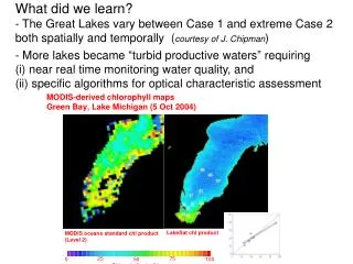
What did we learn? - The Great Lakes vary between Case 1 and extreme Case 2 both spatially and temporally ( courtesy of J. Chipman ).

E N D
What did we learn?- The Great Lakes vary between Case 1 and extreme Case 2 both spatially and temporally (courtesy of J. Chipman) More lakes became “turbid productive waters” requiring (i) near real time monitoring water quality, and (ii) specific algorithms for optical characteristic assessment
Calibration of the Models: Nebraska, 2008 2 MERIS 3-Band MERIS 2-Band MODIS 2-Band Chl-a = 219.32×(Model) + 22.25 Chl-a = 64.05×(Model) - 42.40
Low-to-Moderate Chl-a Concentration, 2008 3 MERIS 3-Band MERIS 2-Band MODIS 2-band
Estimation of chl-a concentrations in different waters 2-band NIR-Red algorithm with MERIS bands calibrated in Nebraska in 2008 Universal Algorithm???
Questions (both “science” and “application”) • What can we do to implement near real time monitoring the Great Lakes water quality using capabilities of NASA, other US agencies and European Space Agency? • How should we be prepared for future space missions?
Things to consider answering Q1 What can we do to implement near real time monitoring the Great Lakes water quality using capabilities of NASA, other US agencies and European Space Agency? What do we have now? 1. Access for current data - MODIS (NASA), - MERIS (ESA), - HICO (US NAVY) - AISA, CASI and other aircraft hyperspectral sensors 2. MODIS algorithms are very good in oligotrophic Case 1 waters and often fail to assess optical characteristics of turbid productive waters (see Jonathan’s example of Green Bay)
MERIS • Ocean color bands typical S:N = 1700 • Spatial Resolution Land & coast: 260m x 300m • Swath Width 1150km, • Global coverage every 3 days • Waveband VIS-NIR: 15 bands selectable across range: 390 nm to 1040 nm (bandwidth programmable between 2.5 and 30 nm)
Hyperspectral Sensors are Currently in Orbit • Hyperion on NASA’s Earth Observing-1 satellite • CHRIS on ESA’s Proba-1 – and none that enables the global mapping of Earth. CHRIS is Europe’s only flying imaging spectrometer, with a spatial resolution of 17 m in up to 62 bands. Despite being designed for a one-year life, it is now operating in its ninth year and is serving more than 300 scientific groups in more than 50 countries. Its data support a wide range of applications, such as land surface, coastal zone and aerosol monitoring.
HICO The Hyperspectral Imager for the Coastal Ocean (HICO) on the International Space Station Naval Research Laboratory, Washington, DC HICO is the first spaceborne hyperspectral imager optimized for characterization of the coastal environment.
10 AISA-Eagle (Airborne Imaging Spectrometer for Applications) - maximum of 256 continuous spectral channels - range 400 – 970 nm - max. spectral resolution 2.3 nm - peak signal-to-noise ratio 490:1 - spatial resolution 2 m at 10,000 ft above ground with 1,000 pixels per swath
One of the answers to Q1 is Q1: What can we do to implement near real time monitoring Great Lakes water quality using capabilities of NASA, other US agencies and European sensors? To calibrate and validate developed algorithms over the Great Lakes using data from all available and near future satellites and aircraft hyperspectral imagers
Questions (both “science” and “application”) • What can we do to implement near real time monitoring Great Lakes water quality using capabilities of NASA, other US agencies and European sensors? • How should we prepare for future space missions?
Things to consider answering Q2 Q2. How should we prepare for future space missions? Three missions are planned in space within the next five years Prisma Italy (2012) EnMap, Germany (2014) HyspIRI, NASA (2015)
1.Prisma Italy’s ASI space agency plans to launch Prisma, a medium-resolution hyperspectral imaging mission, in 2012. Prisma’s hyperspectral camera will be able to acquire images in about 235 channels in the visible and near-infrared and short-wave infrared. Prisma is an Earth-observation system with innovative electro-optical instrumentation that combines a hyperspectral sensor with a panchromatic, medium-resolution camera
2.EnMAP The German Aerospace Center (DLR) and the German Research Centre for Geosciences (GFZ) are planning to launch the EnMAP hyperspectral satellite in 2014 to map Earth’s surface in over 200 narrow color channels at the same time. The primary goal of EnMAP is to offer accurate, diagnostic information on the state and evolution of terrestrial and aquatic ecosystems on a timely and frequent basis, and to allow for a detailed analysis of surface parameters with regard to the characterizations of vegetation canopies, rock/soil targets and coastal waters on a global scale
2.HyspIRI In 2015, NASA (Jet Propulsion Lab) plans to launch the HyspIRI mission, which will acquire images with 210 spectral bands. These data will be used for a wide variety of studies primarily in the Carbon Cycle and Ecosystem and Earth Surface and Interior focus areas. The VSWIR and TIR instruments will both have a spatial resolution of 60 m at nadir. The VSWIR will have a temporal revisit of approximately 3 weeks and the TIR will have a temporal revisit of approximately 1 week.
One of the answers to Q2 is Development of improved algorithms, their calibration and validation over the Great Lakes using data from all available and near future satellites and aircraft hyperspectral imagers
Answers to Q1 and Q2 are 1. Calibration and validation of algorithms over the Great Lakes using data from all available satellites and aircraft hyperspectral imagers. 2. To develop improved algorithms, to calibrate and validate them using data from all available and near future satellites and aircraft hyperspectral imagers We terribly needsupport from NASA, NOAA, and EPA