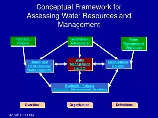
Download
1 / 53
530 likes | 604 Views
GIS: conceptual reminder. Franck Theeten – Bart Meganck. Earth’s Grid System. Coordinates are usually noted in a Cartesian reference system (with 2 axes, bi-dimensional). Y. 4. 3. 1. X. 0. 1. 4. 2. 3. 5. 6. -1. -1. Earth’s Grid System.

E N D
GIS: conceptual reminder Franck Theeten – Bart Meganck
Earth’s Grid System • Coordinates are usually noted in a Cartesian reference system (with 2 axes, bi-dimensional) Y 4 3 1 X 0 1 4 2 3 5 6 -1 -1
Earth’s Grid System • Note: the unit for measurements doesn’t depend from the axes, but from the reference system (it can be degrees, but also meter, Y 4 3 1 X 0 1 4 2 3 5 6 -1 -1
Earth’s Grid System • Note: the unit for measurements doesn’t depend from the axes, but from the reference system : • Reference system is combination of • geoid (real earth surface) • Ellipsoid (mathematical approximation of earth volume) • Shape and position of projection plane • Origin of the 2 axes • Unit of measurement (can be degrees or meter)
Latitude and longitude latitude (parallels) longitude (meridians)
the easy part : latitude • Determine the angle between a position and the earth axis (plane of the equator) • Not affected by earth rotation • Can be measured by comparing angles between the soil and the light coming from the Sun
the hard part : longitude • Value affected by earth rotation • Dependent of time (initially calculated by clocks aligned on local noon) • Definition of a reference meridian is not physical but arbitrary • Often linked to political reason and colonial history • Currently (since the 19th century: Greenwich, UK) • Before, 15th century: Meridian of Tordesillas (separation between Portuguese and Spanish colonies)
the hard part : longitude • Value affected by earth rotation • Dependent of time (initially calculated by clocks aligned on local noon) • Definition of a reference meridian is not physical but arbitrary • Often linked to political reason and colonial history • Currently (since the 19th century: Greenwich, UK) • Before, 15th century: Meridian of Tordesillas (separation between Portuguese and Spanish colonies)
Geodesy: measuring earth • Old style: physical (plumb line) • New style: by satellite
Geodesy: measuring earth • Old style: physical (plumb line) • New style: by satellite
Physical geodesy • Spirit level /plumb line • Theodolite (angles) • rope/tape measure (distances) • ==> LOCAL gravity
Physical geodesy • The GEOID : sum object of all local gravity fields (plumb line)
The Geoid • Sum of local gravities, VERY complex • Not related to altitude
Satellite geodesy • Geoid is not used • Gravity center of Earth is only point that sattellites can “feel”, they know nothing about Earth's surface • Mathematical model for Earth surface : ELLIPSOID
The ELLIPSOID • Mathematical model for Earth surface • Approximation, never exact ! • Not a perfect sphere (1/300 flattening)
Geodetic DATUM • A geodetic datum is a physical realization of a coordinate system used for describing point locations • Contain ALL parameters for your reference system
ALWAYS mention the DATUM • Coordinates without datum are UTTERLY USELESS !!! • Coordinates without datum are UTTERLY MEANINGLESS !!! • Coordinates without datum are COMPLETE NONSENSE !!!
WellKnownTextnotation (WKT) • A) coordinates B) Projection Type « POINT(X Y) » Ex : -POINT(0 0) -LINESTRING(0 0, 1 1, 1 2) -POLYGON (0 0, 1 1, 1 2, 0 0) - … PROJCS["NAD83 / UTM Zone 10N", GEOGCS["NAD83", DATUM["North_American_Datum_1983", SPHEROID["GRS 1980",6378137,298.257222101] ], PRIMEM["Greenwich",0], UNIT["degree",0.0174532925199433] ], PROJECTION["Transverse_Mercator"], PARAMETER["latitude_of_origin",0], PARAMETER["central_meridian",-123], PARAMETER["scale_factor",0.9996], PARAMETER["false_easting",500000], PARAMETER["false_northing",0], UNIT["metre",1] ]
Well Known Text for projection • An important reference: http://spatialreference.org/ • Gives the GDAL expression of some projections that are not embedded by default in tools like QGIS or PostGIS
QGIS: changing the projection settings Tick this box
QGIS: changing the projection settings Select the projection by name Select the projection by categories
Plate Carrée • EPSG:4326 is the default projection of many applicatio, data (GPS, Shapefile) for WGS 84 • Doesn’t prevent local deformation of distances and areas (North appears bigger than equatorial region) • Plate Carrée
Simple Mercator/Plate Carrée • Conserves angles • Distorts surfaces • Distortion at the poles
Simple Mercator/Plate Carrée • Conserves angles • Distorts surfaces • Distortion at the poles
Gall-Peeters map type • Conserves surfaces • Distorts angles
Universal Transverse Mercator • Network of projection arranged by longitude • Cylindrical
Universal Transverse Mercator • Looks a “disco ball” (select small rectangular areas to limit deformation of areas, distances and angles to minimal)
UTM Zones • Interest: unit is meter (distance are easy to express) • But each zone has its own local origin (not bound to the equator) • Most of time cannot be applied on world scale layers
UTM Zones Transerve
UTM Data • Pretty much use for Raster data • elevation data (SRTM) • http://srtm.csi.cgiar.org/ • http://www.cgiar-csi.org/data/srtm-90m-digital-elevation-database-v4-1 • Climatic data • Processed satellite images (LANDSAT) • https://zulu.ssc.nasa.gov/mrsid
Types of data for GIS • Vector data • Raster data
Vector data • Vector layer: • Mathematical expression of a geographicalshape • points, • lines, • surfaces • Easy to reproject (parameter of equation) • Alreadygeoreferenced • ESRI Shapefilemostcommon data standard for shapefiles
Vectordata (shapefile) • A shapefile: • Elaborated by ESRI but widelyused • at least 3 (or eventbetter 4) files with the samename but different extensions that must be out in the samefolder
Vectordata (shapefile) • ***.shp => the shape (drawnform) • ***.dbf=> attribute table (editable in spreadsheet) • ***.shx=>intermediate index • ***.prj=> Metadata of the projection (WKT format)
Raster data • Image file or gridused to display matricial data • Needgeorefencingproject • Hard to reproject QGIS canreprojectthem • Most common standard for • Images • Altitude data (DEM: Digital Elemevation model: http://www.cgiar-csi.org/data/elevation/item/45-srtm-90m-digital-elevation-database-v41) • Climatic data http://www.worldclim.org/download
1) Desktop GIS • Can produce, update verctor and raster data • Can work without Internet connection • Required to procude the base data (backbone of GIS) • Example: • QuantumGIS, Diva-GIS (free) • MapInfo, ESRI ArcINFO (commercial) • …
1) Desktop GIS • Can produce, update verctor and raster data • Can work without Internet connection • Required to procude the base data (backbone of GIS) • Can not publish data on the Internet • Generally poor metadata support • Example: • QuantumGIS, Diva-GIS (free) • MapInfo, ESRI ArcINFO (commercial) • …
2) GIS database • Relational databases with plugins to handle geographical data • No Graphical interface (but Desktop GIS can connect them and display content) • Originally worked on vectors, but soince recently can handle rasters and 3-D data • Powerful to store and modify big vector datasets • Useful to store maps displayed on the Internet
2) GIS database • Example: • PostGIS (GIS plug-in of the OpenSourcePostgreSQL database)
3) GIS web services • Services to displayus the maps on the Internet application • Standardized by Open Geospatial Consortium (a.o. Web Map Server: map are queried via the URL) • Data are often stored in GIS databases • At this level data can easily be completed by metadata
3) GIS web services • Example: • GeoServer (Open source): map server • http://geoserver.org • GeoNetwork (OpenSpource, created by FAO): metadata server • http://geonetwork-opensource.org/