Download
1 / 22
220 likes | 354 Views
VIIRS Land Issues. Robert Wolfe NASA GSFC Code 614.5 NPP MODIS &VIIRS ScienceTeam Meeting May 14, 2008. VIIRS Land Overview (1/3). Instrument NPP/FU1 is locked down and almost ready for TVAC testing testing expected to be completed by end-of-year workaround for thermal focus variation

E N D
VIIRS Land Issues Robert Wolfe NASA GSFC Code 614.5 NPP MODIS &VIIRS ScienceTeam Meeting May 14, 2008
VIIRS Land Overview (1/3) Instrument NPP/FU1 is locked down and almost ready for TVAC testing testing expected to be completed by end-of-year workaround for thermal focus variation as-is cross-talk final characterization during TVAC (small, but not zero risk) more details at VIIRS SDR workshop in Jan. and summary tomorrow NPOESS/FU2 is being built plans include cross-talk and thermal focus fix need to make sure Fire band saturation fix is included
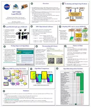
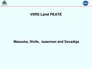
VIIRS Land Overview (2/3) Data Systems Land PEATE on path to be very useful by end of year V1.5 algorithms are being integrated (Masuoka talk later) Alg. Eval: LDOPE tools, ability to compare MOIDS algorithms with NGST algs. CDR: First order are Diagnostic Data Records (DDRs) Algorithms – NGST not moving (at all or) in right direction Recent step backward on Albedo (BPSA will be default)
VIIRS Land Overview (3/3) Interagency Coordination good working relationship NOAA being actively engaged – team is becoming deeper DOD participating, but not very deep Research to (&) Operations CDR funding priorities -- NOAA requesting prop. by end of year Cal/val support – discussions underway Team coordination Currently: meetings every two week include other agencies, IPO and VOAT – no longer have separate interagency coordination telecon include NGST?
VIIRS Land Issues List originated with the NASA NPP Land Science Team Vetted by NOAA and DOD Land Scientists All Land algorithms are covered Issues are not in priority order Supporting details have been provided by ST at TIMs, previous VOAT meetings and other forums Issue list submitted to IPO on Jan. 18, 2008
1. Highest Priority Issues Make Surface Reflectance a Priority IP for cal/val bring forward the calibration phase to immediately post-launch and validation phase to after product has stabilized Need a list of planned land algorithm changes and schedule from NGST
2. Instrument Issues fix aggregation of fire band(s) saturated pixels explore download of full resolution data for FU1 flag saturated pixels prior to aggregation for FU2 need details on fire band high temp calibration watch list: cross-talk, band-to-band, MTF Science team access to EDU / FU1 Relative Spectral Responses (RSRs)
3. Geolocation understand SCI/OPS differences
4. Aerosols incorporate MODIS C5 updates
5. Surface Reflectance incorporate MODIS C5 updates do not mask ocean or clouds
6. VIs formalize TOC NDVI perform blue band error assessment of possible change from 3-band to 2-band EVI
7. Albedo move from broadband to spectral dependent albedo product reconcile DPSA and BPSA evaluate against the specification at 1km, not at 4km current product is produced at 1km, but specification is evaluated at 4km
8. Snow use the NDSI regression method (Salomonson and Appel, 2006) to estimate snow fraction product at ~1 km resolution (serves as surrogate for possible use of MESMA for snow fraction in future) MODIS proxy data testing should include late spring to early summer dates that image melting snow cover in boreal forests and Rocky Mountains
9. Sea-ice substantial problems for ice age assess effects of choice of ice vs. snow thermal emissivity for ice surface temperature EDR review status of relaxed specs. for albedo over sea ice updated/simplifed freshwater ice (ice vs. open water) algorithm still on request list – need formal status report from NGST/IPO
10. Surface Type there are significant implementation questions need plan/schedule from NGST/IPO key priority should be configuration of test-bed in NASA SDS Land PEATE for testing and evaluation
11. LST use different algorithm that explicitly has emissivity as an independent variable and does not depend on mid-IR surface emissivity determine how to deal with VIIRS pixels covering more than one land-cover type with different surface emissivities in the current land-cover based LST algorithm algorithm type should not change upon crossing into/out of sun-glint zone
12. Fire keep moving FRP change forward make sure context information is in product (cloud, etc.)
13. Cal/Val no strategy is in place to store long-term subsets of critical IPs (NSIPS does not plan to accommodate); availability of an extended set of IPs during field campaigns is in question
14. General full chain testing of gridded products chain testing with contaminated, degraded and challenging data fully realize reproducibility through granulated and gridded products make input pointer information useable outside of IDPS system cloud mask – may need tailored test(s) for specific land products NGST has not adhered to standard HDF5 format for xDRs
Summary Issues should be addressed by the IPO Through “EDR Evaluation Tool” process? Good test of working together to improve algorithms Improved algorithms are more likely to meet EDR specs Larger margin (less risk)