Download
1 / 2
20 likes | 126 Views
levate Your Vision with the Best Drone Service Companies in PA. Capture Stunning Aerial Footage, Survey, Inspect, and More. Discover Cutting-Edge Drone Solutions for Your Business Today!

E N D
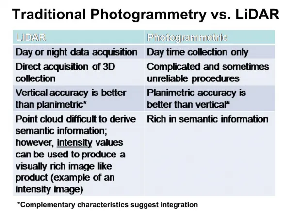
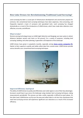
How Lidar Drones Are Revolutionizing Traditional Land Surveying? Land surveying has been a crucial part of infrastructure development and construction projects for centuries. But conventional land surveying techniques have been expensive, time-consuming, and frequently required a team of surveyors and specialized tools. Land surveying has changed dramatically as a result of the introduction of LiDAR drones, which have made data collection more effective, accurate, and efficient. What Is Lidar? Remote sensing technology known as LiDAR (Light Detection and Ranging) uses laser pulses to detect distances between sensors and items on the ground. For a variety of purposes, including land surveying, building, and urban planning, it generates a 3D depiction of the landscape. LiDAR drones have grown in popularity recently, especially among drone service companies PA, thanks to their capacity to quickly and safely collect data from remote areas. LiDAR drones provide various benefits over conventional land surveying techniques. Improved Efficiency And Speed The ability of LiDAR drones to quickly and effectively cover wide regions is one of their key advantages. Surveyors would have to go across the landscape using standard land surveying techniques, taking measurements periodically. This process can take a while, especially in difficult-to-reach places. On the other hand, LiDAR drones can fly over the area and collect data in a lot less time. Businesses that need land surveying services will experience significant cost reductions as a result of this increased efficiency.
Enhanced Accuracy Drones equipped with LiDAR technology are capable of capturing data with centimeter-level accuracy. Whereas, manual measurement techniques used in traditional land surveying may be prone to human error. LiDAR drones produce extraordinarily detailed 3D images that enable surveyors to perform a more thorough analysis of the terrain. This is especially helpful in difficult terrain areas like urban settings where precise measurements are crucial for infrastructure development. Safe Data Collection LiDAR drones can also collect data from dangerous or hard-to-reach locations, including steep slopes or disaster-affected areas, safely. For disaster response teams, who must immediately determine the level of damage caused by natural disasters this can be especially helpful. Pennsylvania aerial lidar is especially helpful in locations that could be hazardous to people, such as mines or nuclear power plants. Surveyors can collect data with LiDAR drones without endangering themselves, lowering the possibility of mishaps or injury. Future Of Lidar Drone Land Surveying Drones with LiDAR technology will become more capable as that technology develops. LiDAR drones could have a larger range of uses in the future, such as asset management, urban planning, and environmental monitoring. Traditional land surveying techniques have transformed with the advent of LiDAR drones. LiDAR drones are projected to become more prevalent in the land surveying sector as technology advances, which will be advantageous for companies and other organizations that need land surveying services. Source Url: https://aerdia.com/services/