Download
1 / 25
250 likes | 439 Views
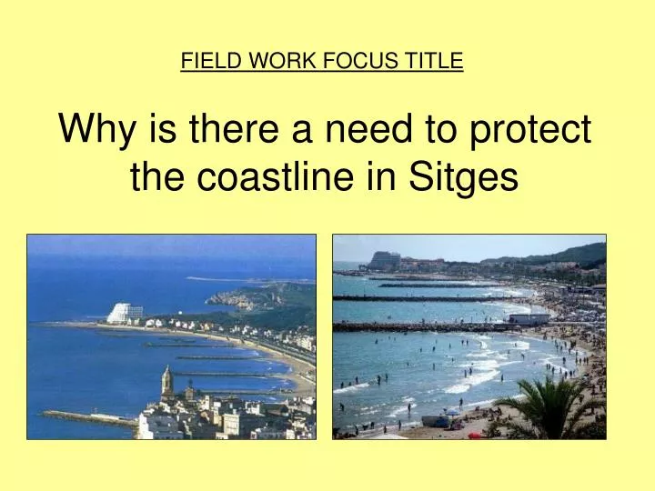
Why is there a need to protect the coastline in Sitges. FIELD WORK FOCUS TITLE. AIM OF PROJECT To describe and explain why is there a need to protect the coastline in Sitges RESEARCH QUESTIONS TO BE ANSWERED RQ1 – Is there a need to protect the coastline in Sitges?

E N D
Why is there a need to protect the coastline in Sitges FIELD WORK FOCUS TITLE
AIM OF PROJECT To describe and explain why is there a need to protect the coastline in Sitges RESEARCH QUESTIONS TO BE ANSWERED RQ1 – Is there a need to protect the coastline in Sitges? RQ2 – Are the coastal management strategies effective in preventing coastal erosion in Sitges?
Data Collection • What should you have collected? • Beach profile measurements • Bipolar evaluation • Field sketches and photos • You should have also noted down general observations, problems and ideas for improvement. There is a fair amount of information in your work booklet.
What is involved in your Controlled Assessment? There are 7 sections to the project 1200 word limit
Getting Started!!!!! • You can put together and bring in relevant maps, pictures and diagrams for your introduction!!!! • You will then be given 1 hour to write up your introduction.
Setting the Scene. – RECOMMENDED WORD LIMIT 200-300 (min 200) TIME LIMIT 1 HOUR This section is all about setting the scene….. • This involves…… • Writing out the 2 research questions. • Is there is a need to protect the coastline in Sitges(see booklet) • Are protection methods often effective? (see booklet) • Then you need to outline the expected outcomes. • This should link into the theory that you have learnt in lessons. • What effect would you expect geology (rock type) and longshore drift to • have on this part of the coastline? Look at the Geology map. Bands of • Hard rock and soft rock. Use the Geography textbooks to help you. Think • about LSD and fetch of the waves as an erosive power. • What methods of protection could they use in Sitges and why? • You then need to include two maps. The first should be a map of Europe • with Sitges clearly marked. The second should be a map of Spain with • Sitges clearly marked. You then need to provide a written description of • the location – do this by annotating your maps.
Locations for wave action study Location 1: Sitges Sandy Beaches x 4. Geology = Clay=weak rock that is eroded quickly. Problem= expensive houses €7 million house, see picture. Solution: sea walls, groynes, beach nourishment.
Location 2: Sitges shingle beach. Clay geology=fast eroding coast. The groynes in Sitges central beaches have starved this beach of its LSD material. Lots of pebbles and rocks but no sand. Groynes and rip rap present.
Location 3 – Destroyed Nightclub. Destroyed 9th October 2O1O
Look carefully at the map and the key above. What landforms would you expect at each location that we visited?
How does wave action affect coastal landforms at Sitges? Wider gently sloping beaches Narrow steeper sloping beaches
Fetch, frequency and direction of waves
Part 2 – Data collection methodsRecommended time 1hourRecommended word count 200 For each piece of data you collected: • Describe the technique used (mention measurements, equipment used, type of sample, sample size) • Explain how the information you collect will help you with the aim of your project or research questions. • Suggest any problems there were with the technique.
Draw a table like the one below & complete for each piece of data you collected.
Example of good practice. Note, your work was not quite the same as this.
Part 3 – Data Presentation • Annotated photos or coastal protection methods. • Annotated sketches • Hand drawn & annotated maps – Geology, location of beaches • Map to show prevailing winds & frequency proportionate arrows – backing up why the coast needs to be protected. • Bi polar results with annotated supporting photos of what you were looking at.
Part 4 - DATA ANALYSIS • In this section you need to:- • Describe the key findings shown by the data you have presented. (this means say what your data shows). • Explain your findings. (this means give reasons for your findings). • REMEMBER YOU ARE TRYING TO IDENTIFY DIFFERENCES BETWEEN DIFFERENT SECTIONS OF THE COASTLINE IN SITGES
Part 5 CONCLUSION AND Part 6 EVALUATION • In this section you need to:- • Revisit the two research questions set out in your introduction (re-read your expected outcomes). • Tackle each question separately, you need to make substantiated conclusions (this means conclusions that are supported by your data).
Continued…. Evaluation • You need to comment on the SUCCESSES of the investigation and more importantly the LIMITATIONS of the investigation. • You need to make suggestions for improving and extending the investigation.
SUMMARY • Describe your findings. • Explain your findings. • Make conclusions that refer back to the original research questions. • Comment on the successes and limitations of your study. • Finally say how you could improve and extend your study.