Download
1 / 17
170 likes | 329 Views
Matsumoto JEPP. IP. Japan EOS Promotion Program (JEPP) Theme 2-2 by Prof. Matsumoto, U-Tokyo Development of rainfall observation system in Southeast Asia.

E N D
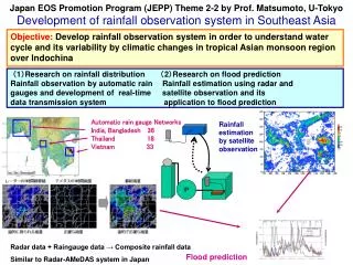
Matsumoto JEPP IP Japan EOS Promotion Program (JEPP) Theme 2-2 by Prof. Matsumoto, U-Tokyo Development of rainfall observation system in Southeast Asia Objective: Develop rainfall observation system in order to understand water cycle and its variability by climatic changes in tropical Asian monsoon region over Indochina (1)Research on rainfall distribution (2)Research on flood prediction Rainfall observation by automatic rain Rainfall estimation using radar and gaugesand development of real-time satellite observationand its data transmission system application to flood prediction Automatic rain gauge Networks India, Bangladesh36 Thailand18 Vietnam33 Rainfall estimation by satellite observation Radar data + Raingauge data → Composite rainfall data Similar to Radar-AMeDAS system in Japan Flood prediction
We have collected quite good data for Indochina Routine Obs. Stations in Ver. 2 http://hydro.iis.u-tokyo.ac.jp/GAME-T/GAIN-T/index.html http://gain-hub.mri-jma.go.jp
18 N High Density Rain Gauges1 High Density Rain Gauges2 Automatic rain gauges in Indochina
Shift of Echo Area Max Time by CAPPI data of Om Koi radar (Okumura et al., GRL) Diurnal Variation of Precipitation Simulated by Cloud Resolving Model (Satomura, 2000: JMSJ)
Topographic Setting of Danang area • Just the South of Hai Van Pass (雲海峠), “climatic divide” of Viet Nam Hanoi Yangon Vientiane Winter Monsoon “Climatic Divide” Da Nang Bangkok Phnom Penh Ho Chi Minh Source : Google Earth
豪雨の総観規模過程 925hPaStream line&v Cold surge(CS) Orographic effect convergence Upward motion Continuous heavy rain Tropical depression(TD) 925hPa divergence
Diurnal and seasonal rainfall variations by automatic rain gauge at Hiep Duc, central Vietnam in 2004 Hiep Duc, 2004 : Month-Hour Diagram
Rainfall in Meghalaya in 2006 Thankalan Park Pynur Mawsingram Cherrapunjee Amlaerem
97 98 99 100ºE Mae Pai Mae Nam Thanlwin Kog-Ma 19ºN Chiang Mai Doi Inthanon (2,565m) Nattaung (2,820m) Mae Ping 18ºN Mae Chaem Mae Yuam Mae Chaem Watershed 3,853km2 282-2,565 masl
Rainfall-elevation 2006年7月降水量 2006年 降水量 2006年9月降水量
In AMY2008… • Hourly rainfall • Radar observations • Some AWS station data in Bangladesh, Meghalaya, Central Vietnam Data will be open through CEOP data-base