Digdeguash River
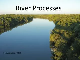
New Brunswick Watersheds Environmental Reporting Series 2007 Digdeguash River Location Community Involvement The Digdeguash River originates from a series of springs near McAdam and flows to the southeast before emptying into Passamaquoddy Bay. The total watershed area is 458 km 2 . Geology

Digdeguash River
E N D
Presentation Transcript
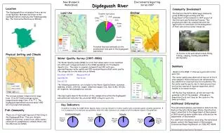
New Brunswick Watersheds Environmental Reporting Series 2007 Digdeguash River Location Community Involvement The Digdeguash River originates from a series of springs near McAdam and flows to the southeast before emptying into Passamaquoddy Bay. The total watershed area is 458 km2. Geology Land Use The Eastern Charlotte Waterways community group (ECW) began working with the Department of Environment in 1997 as part of the Outreach and Partnering Program. This program provides the communities with the opportunity to contribute to the management of their own surface water resources. Forested land and wetlands are the predominant land uses in the Digdeguash watershed. Activities in the watershed include hiking, fishing, camping, boating and wildlife photography. Physical Setting and Climate Water Quality Survey (1997-2006) The Water Quality Index (WQI) is a tool that allows water to be classified into different categories based on the CCME Guidelines for Freshwater Aquatic Life. The index is a number between 0 and 100, with zero representing poor water quality and 100 representing excellent water quality. The categories for the index are as follows: Excellent: 95-100 Marginal:45-64 Good:80-94 Poor:0-44 Fair:65-79 The following parameters are included in the Water Quality Index: aluminum, ammonia, arsenic, chloride, copper, dissolved oxygen, iron, lead, nickel, nitrate, pH, sulphate, total phosphorus, and zinc. The map (right) depicts the location of the sample sites within the Digdeguash watershed and indicates the calculated WQI rating for each site. Summary • Based on the WQI, 7 sites were good and 2 sites were fair. • Fair water quality was observed at two out of the 9 sites sampled. These sites were not influenced by any industrial or municipal sources of pollution. The fair water quality may be due to land use practices such as the removal of riparian vegetation, which results in increased erosion. • Of the four key indicators, pH did not meet the guideline in 8% of the samples. Atmospheric deposition (“acid rain”) may be the cause for the lower pH values. The average summer temperatures range from 13 to 16°C while average winter temperatures range from -4 to-7° C. The Digdeguash watershed receives about 1400 mm of precipitation annually. Additional Information Key Indicators In addition to using the CCME Water Quality Index, four key indicators of water quality were evaluated against available guidelines. E. coli is compared to recreational use guidelines, while the other indicators are compared with freshwater aquatic life guidelines. This watershed summary was based on data from the Eastern Charlotte Waterways’ Water Classification report submitted to the Department of Environment in 1999 as well as water quality data collected by the Department of Environment. For additional information concerning this watershed please, contact the Department of Environment, Sciences and Reporting Branch, at ( 506) 457-4844. Photos and maps by: Department of Environment Fish Community pH Dissolved Oxygen E.coli Nitrate There are at least eight species of fish living in the Digdeguash River. They are: Atlantic salmon, brook trout, brown trout, white sucker, yellow perch, pumpkinseed, common shiner, and the American eel (DNR). Met the guideline 100% Met the guideline 100% Met the guideline 100% Did not meet the guideline 8% Met the guideline 92%