
The flooded forest … the Sunderbans… Let’s discover more…
The flooded forest … the Sunderbans… Let’s discover more…. Where is it?. Bay of Bengal. What facts did you discover?. Size 1330 km² 2/3 of the Sunderbans are in Bangladesh 70% of the Sunderbans is under saline water Sunderbans is a Mangrove Forest…trees have their feet in water…

The flooded forest … the Sunderbans… Let’s discover more…
E N D
Presentation Transcript
The flooded forest … the Sunderbans… Let’s discover more… Thanks to Sarah Todd and her colleagues at Stanchester High School, Somerset made available through www.sln.org.uk/geography
Where is it? Bay of Bengal Thanks to Sarah Todd and her colleagues at Stanchester High School, Somerset made available through www.sln.org.uk/geography
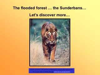
What facts did you discover? • Size 1330 km² • 2/3 of the Sunderbans are in Bangladesh • 70% of the Sunderbans is under saline water • Sunderbans is a Mangrove Forest…trees have their feet in water… • This area is only accessible by waterways • 3 animals found here:- Bengal Tiger, Crocodile and Fiddler Crab • …Marine Turtles, Dolphins, Sharks (Argh!) • Humming birds, Curlews, Jungle fowl, • Bengal Tiger only lives here. Thanks to Sarah Todd and her colleagues at Stanchester High School, Somerset made available through www.sln.org.uk/geography
How hot is it? • The climate is hot…42°C • It is a humid area. It has a tropical maritime climate…that means it is in the tropics and it is close to the sea…so it rains a lot. • In fact there are Monsoons… • A Monsoon is a period of intense heavy rain for one season of the year. • The wet season lasts from June to September…and you can get tropical cyclones in this season…70% of all rain is in this season • The winter is dry and cool (9 ° C) … this lasts from November to April… Thanks to Sarah Todd and her colleagues at Stanchester High School, Somerset made available through www.sln.org.uk/geography
Why is it being managed? • To preserve and prevent loss of its value as a world heritage site. • Extraction of forest resources eg. Tigers, has had a negative effect on the environment and so is regulated by laws. • Eco-tourism is encouraged so the area can be enjoyed but at the same time protected. • Eco-tourism is sustainable tourism which uses local resources, renewable energy and does not damage the environment. • You can only travel on water ways, your money goes to locals, you are always escorted and you have minimum impact on this area. • Eco-tourism brings in revenue to the country and it provides raw materials for wood based industries. Traditional forest produce eg. Timber, pulpwood and fuelwood. Large scale harvest of non wood forest products takes place regularly. Thanks to Sarah Todd and her colleagues at Stanchester High School, Somerset made available through www.sln.org.uk/geography
What was your favourite fab fact? OURS WERE: All the tigers are man eaters - grrrrrrrrr The tourist lodge is run completely on solar energy – how efficient!! Red crabs scurry along the river banks – run from that high tide! Thanks to Sarah Todd and her colleagues at Stanchester High School, Somerset made available through www.sln.org.uk/geography
5 minute Challenge • Using what you now know about the Sunderbans, answer the questions on p7 of your Holiday Scrapbook. • Make sure that your map is annotated to show where the Sunderbans are located. Here’s a quick reminder! Thanks to Sarah Todd and her colleagues at Stanchester High School, Somerset made available through www.sln.org.uk/geography
You are well into your excursion and need to write a postcard home. In this postcard you must incorporate the following words and information to try and help keep the Sunderbans sustainable: What image will you draw to portray the Sunderbans? Writing Home. Sustainability Eco-tourism Salinisation Type of ecosystem and the main animals found within it. Climate Your adventures with the man eating tigers! Thanks to Sarah Todd and her colleagues at Stanchester High School, Somerset made available through www.sln.org.uk/geography
Homework • You must complete your postcard from the Sunderbans remembering that you need to include: • An image representing the Sunderbans on the front. • Key facts about the Sunderbans, and how its is currently kept sustainable. HAPPY WRITING! Thanks to Sarah Todd and her colleagues at Stanchester High School, Somerset made available through www.sln.org.uk/geography