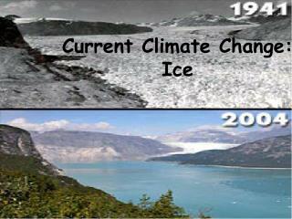
Ice Sheet Change
Ice Sheets - A mass of glacial ice the covers surrounding terrain and is greater ... Pine Island Glacier, Antartica Image taken by ASTER December 2000 ...

Ice Sheet Change
E N D
Presentation Transcript
Ice Sheet Changes From Space Ashleigh Bomar GEO 391 06/05/07
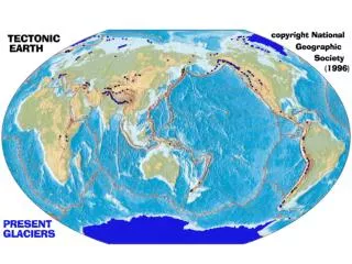
Antarctic Ice Sheet Largest single ice mass on Earth Covers an area of 14,000,000 km2 Contains over 30,000,000 km2 of ice Rests on terrain in East Antarctica, but extends nearly 2500 meters below sea level in West Antarctica Greenland Ice Sheet Second largest ice mass on Earth Covers an area of 1,833,900 km2 Covers over 80% of Greenland Ice averages a depth of 2.3 kilometers, but the summit is nearly 3 kilometers in depth Ice Sheets - A mass of glacial ice the covers surrounding terrain and is greater than 50,000 km2 Global Image of Ice sheets
Wildlife Extinction Global Sea Level Rising Possible Extreme Weakening of the Gulf Stream Changes in global climate due to surface albedo – “Albedo is the ratio of reflected to incidentelectromagnetic radiation. It is a unitless measure indicative of a surface's or body's diffuse reflectivity. The word is derived from albus, a Latin word for "white".” http://en.wikipedia.org/wiki/Albedo Percentage of reflected sun light in relation to various surface conditions of the earth Consequences of Ice Sheet Melting
http://en.wikipedia.org/wiki/Image:Antarctic_shelf_ice_hg.pnghttp://en.wikipedia.org/wiki/Image:Antarctic_shelf_ice_hg.png A Tour of the Cryosphere
Ice Streams • “An ice stream is a region of an ice sheet that moves significantly faster than the surrounding ice. Ice streams are significant features of the Antarctic where they account for 10% of the volume of the ice. They are up to 50 km wide and 2 km thick. They stretch for hundreds of kilometres and account for most of the ice leaving the ice sheet, and entering the ice shelf. • The speed of the ice in the ice stream can be 1,000 meters per year, an order of magnitude faster than the surrounding ice. The shear forces at the edge of the ice stream causes deformation and recrystallization of the ice from hard glacial ice to a softer and more brittle form. Crevasses form particularly around the shear margins” DOWN THE RIVER. The material in ice streams flows much faster than does the ice on nearby highlands. Blue tint denotes speeds of less than 10 meters per year; red denotes speeds of 1 kilometer per year or more.Byrd Polar Research Center, NASA, Canadian Space Agency http://en.wikipedia.org/wiki/Ice_stream
GRACE (Gravity Recovery and Climate Experience) • Composed of two satellites in polar orbit approximately 200 km apart. • Energized by solar panels with no moving parts • Polar orbit so it measures the gravity field of the entire Earth. • Measures change in mass which shows a negative increase in the amount of mass over the ice sheets in Antarctic and Greenland ice sheets • Difficult to tell exactly what's going on with the glaciers compared to the surrounding water This figure shows the ice mass loss in Antarctica as observed by Grace over the period 2002-2005 (see browse image) measured in cubic kilometers per year. The ice mass loss observed contributes about 0.4 millimeters (.016 inches) per year to global sea level rise. Image credit: University of Colorado
“…a project designed to monitor the world's glaciers primarily using data from the ASTER (Advanced Spaceborne Thermal Emission and reflection Radiometer) instrument aboard the EOS (Earth Observing System) Terra spacecraft, launched in December, 1999.” ASTER's three subsystems are: the Visible and Near Infrared (VNIR), the Shortwave Infrared (SWIR), and the Thermal Infrared (TIR). Pine Island Glacier, Antartica – Image taken by ASTER December 2000 GLIMS – Global Land Ice Measurements From Space
Figure 7. Byrd Glacier, Antarctica. (top) ASTER image mosaic. (bottom) Surface flow speeds determined by a 1978 theodolite survey (left), and feature tracking in ASTER image analysis using two recent images (center) and the velocity change (right) during two recent time periods. Contributed by Gordon Hamilton and Leigh Stearns (University of Maine).
Fig. 1. Diagrammatic justification for world glacier monitoring. Center of the diagram illustrates key elements of basic glaciological science; yellow-green elements are key areas of investigation by GLIMS. Stream flow and glacier net mass balance (shown in purple in the “science” part of the diagram) are the key links between glaciers and their practical importance to people and natural ecosystems and our understanding of climate change, as shown in the “Impacts” and “Fundamental Understanding” parts of the diagram.
ERS Radar Altimeters • ERS radar altimeters work by sending 1800 separate radar pulses down to Earth per second then recording how long their echoes take to bounce back 800 kilometers to the satellite platform. The sensor times its pulses' journey down to under a nanosecond to calculate the distance to the planet below to a maximum accuracy of two centimeters. • A Norwegian-led team used the ERS data to measure elevation changes in the Greenland Ice Sheet from 1992 to 2003, finding recent growth in the interior sections estimated at around six centimetres per year during the study period. • The result is a mixed picture, with a net increase of 6.4 centimetres per year in the interior area above 1500 metres elevation. Below that altitude, the elevation-change rate is minus 2.0 cm per year, broadly matching reported thinning in the ice-sheet margins. The trend below 1500 metres however does not include the steeply-sloping marginal areas where current altimeter data are unusable. • The results showed thickening in East Antarctica on the order of 1.8 cm per year, but thinning across a substantial part of West Antarctica. http://www.sciencedaily.com/releases/2005/11/051107080830.htm
ICESat/GLAS • "The ICESat mission will provide multi-year elevation data needed to determine ice sheet mass balance as well as cloud property information, especially for stratospheric clouds common over polar areas. It will also provide topography and vegetation data around the globe, in addition to the polar-specific coverage over the Greenland and Antarctic ice sheets." IceSat Orbit on June 7th, 2007 Current Location of ICESat First Ice Sheet Thickness Images
Results • ERS - “…but there is still no consensus assessment of the ice sheet's overall mass balance.”1 • GRACE – “In an update to findings published in the journal Geophysical Research Letters, a team led by Dr. Isabella Velicogna of the University of Colorado, Boulder, found that Greenland's ice sheet decreased by 162 (plus or minus 22) cubic kilometers a year between 2002 and 2005. This is higher than all previously published estimates, and it represents a change of about 0.4 millimeters (.016 inches) per year to global sea level rise. “2 1- http://www.geosummit.org/resource/0511_Envisat.html 2- http://www.jpl.nasa.gov/news/news.cfm?release=2005-176
Constructing and launching ESA’a CryoSat 2 (the first was lost during launch October 2005) which would contain the world’s first altimeter designed to examine and acquire data from the steeply sloping margins on the lower elevations of the ice sheets. Continue field study in Antarctic and Greenland monitoring declining ice mass as well as many other factors Continue collecting and analyzing GLIMS data as well as other satellite data Possible Future Studies