Download
1 / 13
130 likes | 170 Views
3D laser scanning is a technology that scans and analyses real-world objects or environments using a device called a 3D laser scanner and creates a digital representation of it.<br>

E N D
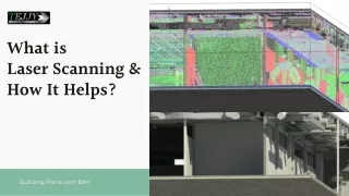
What is Laser Scanning & How It Helps? Building Plans with BIM
What is 3D Scanning? 3D laser scanning is a technology that scans and analyses real-world objects or environments using a device called a 3D laser scanner and creates a digital representation of it. To Know More:
LIDAR History of Scanning 3D SCANNING
What is SCAN to BIM Process Scan to BIM process is non-destructive technology. It digitally captures dimensions and exact measurement of building structures. The main purpose behind hiring 3D laser scanning companies is renovation, demolition, addition in building design. The scan to BIM process Light from a laser scanning system is bounced off onto the surface to be scanned. The laser beam strikes the surface and is reflected back to the sensors. The sensors calculate the time taken by light to complete its journey from emission to reflection. This time measurement is known as “time of flight” . Time of flight helps us to calculate how far the surface is located. Within seconds of single scan millions of 3D coordinates are collected. These 3D coordinates are known as point cloud data. Point cloud scan data is converted into 3D model using point cloud modeling software. The accuracy and precision received in the scan to BIM process has revolutionized surveying process.
Improved accuracy and Quality with Reduced Errors BENEFITS Streamline productivity with reduced rework Improved Planning between new design element and existing designs with cloud database Remote sensing ability ensures risk management Scan data with BIM to compare stages of construction Reduced Cost reduction increases project profitability.
CLASH DETECTION RENOVATION AND RETROFIT SITE DESIGN COORDINATION IN CONSTRUCTION Data is used for demolition, building addition, renovation and building operations. Complex MEP model with detailed information. It serves a variety of purposes, making presentations powerful tools for teaching. Streamlines Coordination with Improved Decision Making APPLICATION OF SCANNING
Challenges with 3D Scanning BEING OPTICAL IN NATURE ANYTHING BEYOND SCANNING LIGHT CANNOT BE SCANNED TRAINED PROFESSIONALS ARE REQUIRED SURVEYORS OR ARCHITECTS NEED TO BE AWARE ABOUT THE CONSTRUCTION LOCATION IT'S EXPENSIVE HUMIDITY AND AMBIENT TEMPERATURE CAN CREATE UNSCALABLE SCANS
Our philosophy "RECOGNIZING THE NEED IS THE PRIMARY CONDITION FOR DESIGN.” DESIGN BUILD FIRM
STEP 1 STEP 3 STEP 4 Place the laser scanner on a tripod at the required location and calibrate it. The recorded data is imported to the software to produce a 3D model of the structure. The laser beams ejected from the scanner acquires the real-time data and the data is recorded. Building Scan Process STEP 2 Start the laser scanner to scan the structure.
WEBSITE www.tejjy.com EMAIL Work with us info@tejjy.com CONTACT NUMBER 202-465-4830