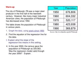
Map of Antarctica: en.wikipedia/wiki/File:Antarctica.svg
Map of Antarctica: http://en.wikipedia.org/wiki/File:Antarctica.svg. Antarctica: shaded relief: http://lima.nasa.gov/antarctica/ ; http://lima.nasa.gov/img/shaded_relief.jpg. Elevation: http://lima.nasa.gov/img/elevation.jpg. Antarctic Ice Flow rates: http://lima.nasa.gov/img/rignot_basins.tif.
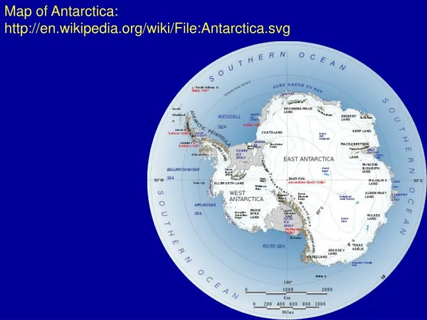

Map of Antarctica: en.wikipedia/wiki/File:Antarctica.svg
E N D
Presentation Transcript
Map of Antarctica: http://en.wikipedia.org/wiki/File:Antarctica.svg
Antarctica: shaded relief: http://lima.nasa.gov/antarctica/; http://lima.nasa.gov/img/shaded_relief.jpg
Antarctic Ice Flow rates: http://lima.nasa.gov/img/rignot_basins.tif
Antarctica – 3D: http://www.geographicguide.com/antarctica.htm
Transantarctic mountains: http://photolibrary.usap.gov/Portscripts/PortWeb.dll?query&field1=Filename&op1=matches&value=LANDSCAPE3.JPG&catalog=Antarctica&template=USAPgovMidThumbs
Antarctic icebergs: http://www.photoseek.com/antarctica.html
Beardmore Glacier: http://lima.nasa.gov/img/beardmoreglacier.jpg; http://lima.nasa.gov/antarctica/
Ross Ice Shelf: http://earth.rice.edu/mtpe/cryo/cryosphere/cryosphere_why.html
Looking for meteorites (I have permission for this from Randy Korotev)
Antarctica – Larsen B: http://lima.nasa.gov/img/larsenb.jpg
Larsen B Ice Sheet: http://www.globalwarmingart.com/wiki/Glacier_Gallery
Ice Flow rates: http://upload.wikimedia.org/wikipedia/commons/d/d3/Bambervelocity.jpg
Bedrock: http://en.wikipedia.org/wiki/File:AntarcticBedrock.jpg
Temperature trend: http://en.wikipedia.org/wiki/File:Antarctic_Temperature_Trend_1981-2007.jpg
Dome C: http://en.wikipedia.org/wiki/File:AntarcticaDomeCSnow.jpg
North Pole Ice Sheet: http://greentheo.scroggles.com/2007/12/27/the_north_pole_is_shrinking_and_the_sout/
North Pole Ice Sheet: http://www.talkingscience.org/2011/02/paddling-polar-bears/