Philippine Bathymetry
This presentation delves into the intricate underwater topography of the Philippines, exploring its diverse bathymetric features. From deep trenches to shallow shelves, we'll examine the geological processes that shaped this unique underwater landscape.

Philippine Bathymetry
E N D
Presentation Transcript
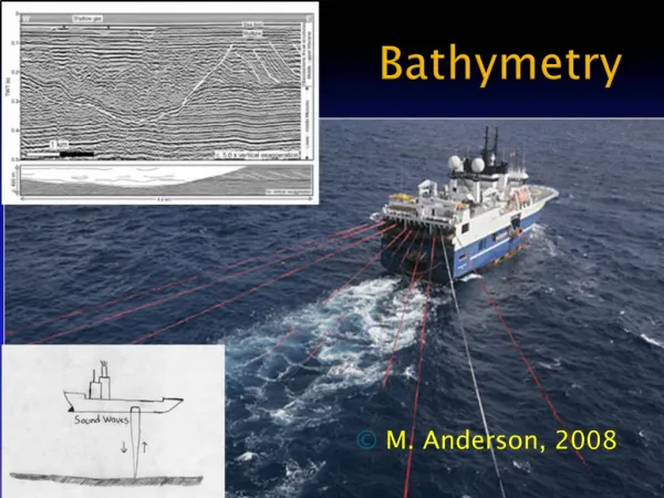
BATHYMETRY Presented by:Moran,E&Paulines,S.
BathymetryIsthestudy ofunderwater depthoflakeoroceanfloors. • Paleobathymetryisthestudy ofpastunderwater depths.
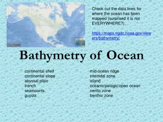
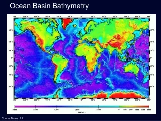
Bathymetry • Objecive ofbathymetric measurement: • toshowthetopographyoftheoceanfloor • Bathymetric (orhydrographic)charts • Involvestheproduction ofoceanandseamapsbaseduponbathymetric data • represent theoceandepthasafunction ofgeographicalcoordinates • typicallyproducedtosupportsafetyofsurface orsub-surfacenavigation • showseafloor relief orterrain ascontourlines(calleddepthcontoursorisobaths) • DigitalTerrainModelandartificial illumination techniques • usedtoillustrate thedepthsbeingportrayed • Selected depths(soundings) • provide surface navigationalinformation
Measurements Techniquesindetermining Bathymetry Product B Feature 1 Feature 2 Feature 3 Soundingline Sonar system Sonartechnique Radar/SEASAT
Techniques indetermining bathymetry • Soundingline • Sonarsystem • Sonartechnique • Radar/SEASAT
Sounding line - A weighted rope or wire lowered overboard until it touched the ocean floor. - The only way to measure ocean depth for hundreds of years ago. Disadvantages: - Time-consuming: It took a long time to lower and retrieve the line, especially in deep water. - Inaccurate: The line could be affected by currents or ship drift, leading to inaccurate depth readings. - Difficult to tell when the sounding line had actually touched bottom: This made it difficult to get accurate measurements.
SonarSystems - Sonar stands for SOund Navigation Ranging. - It measures distances by emitting a short pulse of high-frequency sound and measuring the time until an echo is heard. - Sonar was invented during World War II (1939-1945). - After the war, ships with sonar units attached to their hulls crisscrossed the world's oceans systematically, measuring depth. - The data collected made possible complete bathymetric maps of the world's oceans.
Side-scanSonar - Side-scan sonar is also sometimes called side scan sonar, sidescan sonar, side looking sonar, side-looking sonar, side imaging sonar, side-imaging sonar and bottom classification sonar. - Side-scan sonar is a category of sonar system that is used to efficiently create an image of large areas of the sea floor.
UsesofSide-scanSonar - Side-scan sonar uses a sonar device that emits conical or fan-shaped pulses down towards the seafloor across a wide angle perpendicular to the path of the sensor through the water. This device can be towed from a surface vessel or submarine, or mounted on the ship's hull. - The intensity of the acoustic reflections from the seafloor of this fan-shaped beam is recorded in a series of cross-track slices. - When stitched together along the direction of motion, these slices form an image of the sea bottom within the swath (coverage width) of the beam. - The sound frequencies used in side-scan sonar usually range from 100 to 500 kHz; higher frequencies yield better resolution but less range.
UsesofSide-scanSonar - Mapping the seabed. - Creation of nautical charts. - Detection and identification of underwater objects and bathymetric features. - Used to conduct surveys for maritime archaeology. - Used to detect debris items and other obstructions on the seafloor. - Assessment on the status of pipelines and cables on the seafloor. - Provide a glimpse of the shallow structure of the seabed. - Used for fisheries research, dredging operations, and environmental studies - Military applications including mine detection
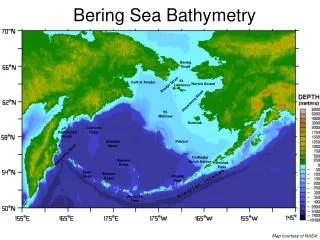
What bathymetric features can you see in the Northern Pacific? • Continentalslope • Seamounts • AbyssalPlains • Trenches
Methodsusedforbathymetric surveys Multibeamsurveying This is a survey that is typically done in larger bodies of water as opposed to smaller ones. In this survey, the surveyors attach a multi-beam echo sounder to a boat. This sounder sends out a wide variety of beams across a large area of the floor of the water. How this works is that as the beams bounce back from the floor of the water, us surveyors collect and process the incoming data. We can view this data in real time during the survey. So the results come in pretty fast, which means the whole process speeds up since there is no lag time to find anything out.
Methodsusedforbathymetric surveys Singlebeamsurveying So this is essentially the same process as the multi-beam survey, but instead of sending out multiple beams it is just the one beam. Which means it is generally used for smaller bodies of water. During this bathymetric survey method, surveyors measure the water depth that is directly under the boat.
Methodsusedforbathymetric surveys Ecomapper The Ecomapper is a self-driving underwater vehicle that collects crucial and accurate bathymetric data. So precise that it does it down to one-foot contours that are very difficult to reach with boats. How it does this is to utilize a side-scan sonar and a Doppler velocity log.
Methodsusedforbathymetric surveys Subbottomprofiler Surveyors commonly use a sub-bottom profiler to view the layers of sediment and rocks under the water body floor. How it works is that a transducer sends a sound wave to the water body floor and collects data. This sound wave can even penetrate the floor of the water. In the end, the sound waves send back data and in return can map out the layers beneath the water body flow.
Methodsusedforbathymetric surveys Acoustic Doppler Current Profiler An Acoustic Doppler Current Profiler, or an ADCP, measures streamflow. How they work is that they measure the water velocity by transmitting sound waves which then reflect off sediment and other materials in the water. The collection of data at the end can be used for detailed bathymetric mapping.
Usesofbathymetric surveys Bathymetric surveys can be important for a wide number of reasons, particularly in terms of aiding navigation and dredging activities, and supporting land projects.
Usesofbathymetric surveys • Navigation • Dredging • LandDevelopment Projects
How is the bathymetry important to marine life? Bathymetric features such as the continental shelf and seamounts interact with ocean currents and winds to produce regions of upwelling, where nutrient-rich waters are brought to the surface. This nutrient-rich water supports high levels of primary production by phytoplankton, which in turn attracts larger organisms. Seamounts are colonized by organisms that filter food particles out of the water column, called “filter feeders”. These organisms trap food in water as it is upwelled along the edges of seamounts. Larger organisms such as fish and mammals are attracted to the productive feeding grounds on the surface of seamounts and in the overlying water. The image below shows a three-dimensional view of the actual track of an elephant seal projected onto a bathymetry map. You can see that it spends quite a bit of time diving up and down around the top of a seamount. The seal is likely feeding on organisms that inhabit the seamount.
Source: Maxwell, S. M., J.J. Frank, G.A. Breed, P.W. Robinson, S.E. Simmons, D. Crocker, J. Gallo-Reynoso, and D.P. Costa (2012) Benthic foraging on seamounts as a specialized foraging behavior on seamounts by deep diving marine mammal. Marine Mammal Science 28(3): E333-E344.
Bathymetric Map of Major Seas in the Philippines All seas surrounding the Philippines are branches of the Pacific Ocean. - Philippine Sea: Located east of the Philippines, it features the Philippine Trough (Emden Deep), which plunges to 10,430 meters (34,219 feet). - South China Sea: Located northwest of the Philippines. - Sulu Sea: Located southwest of the Philippines, surrounded by the country on three sides. - Celebes (Sulawesi) Sea: Located south of Mindanao, between the island and Indonesia. - Bohol Sea: Located north of Mindanao. - Visayan Sea: Encircled by Panay, Masbate, Cebu, Negros, and other islands. - Sibuyan Sea: Meets southern Luzon and eastern Mindoro. - Camotes Sea: Lies between Cebu, Leyte, and Bohol. - Samar Sea: Lies between Samar and Masbate.
Area and depth of the major oceans Source:(InternationalHydrographicOrganization,2000)
Bathymetric Map of Major Seas in the Philippines All seas surrounding the Philippines are branches of the Pacific Ocean. - Philippine Sea: Located east of the Philippines, it features the Philippine Trough (Emden Deep), which plunges to 10,430 meters (34,219 feet). - South China Sea: Located northwest of the Philippines. - Sulu Sea: Located southwest of the Philippines, surrounded by the country on three sides. - Celebes (Sulawesi) Sea: Located south of Mindanao, between the island and Indonesia. - Bohol Sea: Located north of Mindanao. - Visayan Sea: Encircled by Panay, Masbate, Cebu, Negros, and other islands. - Sibuyan Sea: Meets southern Luzon and eastern Mindoro. - Camotes Sea: Lies between Cebu, Leyte, and Bohol. - Samar Sea: Lies between Samar and Masbate.
THANKYOUFORYOUR ATTENTION! Presented by:Moran,E&Paulines,S.