Download
1 / 6
0 likes | 24 Views
The Advantages of Using Drones for Mining Exploration: A Comprehensive Guide is a must-have resource for anyone involved in the mining industry. This comprehensive guide provides valuable insights into the numerous advantages of utilizing drones for mining exploration.

E N D
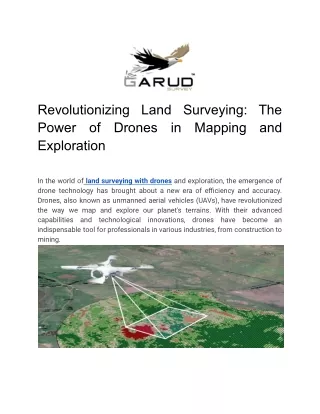
Revolutionizing Land Surveying: The Power of Drones Exploration in Mapping and In the world of land surveying with drones and exploration, the emergence of drone technology has brought about a new era of efficiency and accuracy. Drones, also known as unmanned aerial vehicles (UAVs), have revolutionized the way we map and explore our planet's terrains. With their advanced capabilities and technological innovations, indispensable tool for professionals in various industries, from construction to mining. drones have become an
One of the key applications of drones in land surveying is drone mapping services. With the use of high-resolution cameras and advanced software, drones can capture aerial imagery and create detailed maps with exceptional precision. Traditionally, land surveying measurements, which were time-consuming and prone to human errors. However, drones have eliminated these limitations by providing a faster and more accurate alternative. involved painstaking manual Drone mapping services offer a range of benefits that make them an attractive option for professionals. Firstly, the speed at which drones can cover vast areas is unmatched. In a fraction of the time it would take traditional surveying methods, drones can collect data from large expanses of land, allowing for quicker decision-making and project planning. This translates into significant time and cost savings for businesses. Furthermore, drone mapping services provide a level of detail that was once unimaginable. With the ability to capture high-resolution images and videos,
drones can reveal intricate features and topographic details that might have been missed in the past. This enhanced level of detail allows for a more comprehensive understanding of the surveyed area, which can be critical for effective decision-making in industries infrastructure development. such as urban planning and Another application of drones in land surveying is their use in drone topographic surveys. Topographic surveys involve measuring and mapping the physical features of a given area, including elevation, slopes, and natural features. Traditionally, these surveys required extensive fieldwork and manual measurements. However, drones have made this process significantly more efficient by capturing aerial imagery and using advanced software to generate accurate topographic maps. The use of drones for topographic surveys offers inherent advantages over traditional methods. Firstly, drones can access areas that may be difficult or dangerous for humans to reach, such as steep slopes or high elevations. By eliminating the need for human intervention in these challenging terrains, drones ensure the safety of surveying professionals while still delivering highly accurate data.
Moreover, drones for mining exploration have gained popularity in recent years. Mining companies are leveraging the capabilities of drones to identify potential mineral-rich areas and plan their extraction operations more effectively. By conducting aerial surveys, drones can cover vast areas in a short period, providing mining companies with essential data on the geological features of the land, the presence of minerals, and potential environmental risks. With the use of drones, mining companies can optimize their exploration efforts, targeting areas with the highest likelihood of containing valuable resources. This not only reduces costs associated with exploration but also minimizes the environmental impact by minimizing unnecessary excavations. However, while the advantages of drone technology in land surveying and exploration are evident, it is essential to acknowledge the challenges and considerations associated with its adoption. One of the primary concerns is drone mapping pricing, as the initial investment in drones and the required software can be significant. Nevertheless, the long-term benefits and cost savings derived from drone technology more than make up for the initial investment.
Additionally, regulatory and legal frameworks need to be in place to ensure the safe and responsible use of drones. Governments around the world have implemented regulations governing requirements, flight restrictions, and privacy considerations. Compliance with these regulations is vital to ensure the integrity and credibility of drone mapping services and to protect the privacy and safety of individuals and properties. drone usage, including licensing In conclusion, drones have truly revolutionized land surveying and exploration. Their ability to capture high-resolution imagery, generate detailed maps, and access challenging terrains has transformed traditional surveying methods. Whether it is for mapping purposes, topographic surveys, or mining exploration, drones have proved to be powerful tools that enhance efficiency, accuracy, and safety in these industries. As technology continues to advance,
the future of land surveying and exploration looks bright with the power of drones.