Download
1 / 7
70 likes | 216 Views
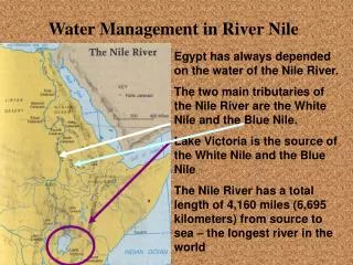
WATER MANAGEMENT IN THE NILE BASIN. Presentation of the documents. Two documents are extracted from « Hâtier history and geography » classes européennes , published in 2006. Document one is a paragraph which presents the Nile, describing the world longest river from its roots to its delta.

E N D
Presentation of the documents Two documents are extracted from « Hâtier history and geography » classes européennes , published in 2006. Document one is a paragraph which presents the Nile, describing the world longest river from its roots to its delta. Document two is a regional map of North East Africa, which locates the Nile and focuses on how it is planned. In the key some colors show the average annual rainfall, some signs show the dams, other colors show the irrigated areas and to finish the map locates the countries which belong to the Nile Basin Initiative. The last document is a text, adapted from David Waugh « the new wilder world », published by Nelson in 1998.. It explains some Irrigation projects launched by the Egyptian government but also alludes to the risks caused by the possible depletion of the Nile’s flow.
QUESTION 2: HOW MANY COUNTRIES DEPEND ON THE NILE? In document one it is written that Egypt and Sudan share the Nile: « Under the 1959 Nile agreement…basis ». But it’s also written that 8 other countries lie in the White Nile basin , one of the Nile’s tributaries. On the map we can see some of them: Republic democratic of Congo, Ethiopia, Eritrea, Kenya, Uganda The text alludes to the Nile Basin Initiative ( last paragraph) and its 10 members: but we can only see 7of them on the map.( they are underlined) Burundi, Rwanda, Tanzania are missing. The NBI is a project to plan the Nile in common so as to use its water as well as possible.
WHAT FAMOUS PROJECT DID EGYPT LAUNCH IN 1971? The text one explains: « From 1960 to 1971…water storage lake ». So this project was in fact the building of a huge dam ( the Aswan Dam) in the South of the country in order to start irrigation projects ad production of electricity like we can see on the map.
HOW WAS THE NILE PLANNED? GIVE EXAMPLES AND PURPOSES OF SOME PLANNING PROJECTS The map clearly show how the Nile is planned: -Dams are built or are planned to be built: it is to create artificial lakes so as to irrigate lands that are very dry. For instance there is the Aswan dam in Egypt which created Lake Nasser a huge storage water lake. -Canals are built as well: there are lots of them in Egypt. One goes from lake Nasser into dry lands: this is the New delta project the text 3 explains this project could allow the cultivation of 600 000 hectares. -Many irrigated areas have been also created along the Nile: in Egypt between Aswan and Cairo or in Sudan around Khartoum.
ACCORDING TO DOC 3 WHY IS THE NILE SO IMPORTANT FOR EGYPT? Lines 1 to 11, text 3 explains that Egypt’s population grows fast and cities spread more and more. So Egypt needs more food and more lands for people to settle! In Egypt the climate is very dry in some regions ( map 2) and water is badly needed. The Nile is the main source of water for the country. The text explains in the second paragraph, that canals using the Nile’s water, such as the Al Salam canal, have been very useful to create new irrigated areas and attract population to new places, slowing down the growth of Cairo. It is also a means to create more lands to be cultivated: « less cultivated lands…upon ».
WHAT USES OF THE NILE ARE PLANNED IN THE FUTURE BY THE EGYPTIAN GOVERNEMENT? The text 3 mentions this recent project: it is called the NEW DELTA PROJECT. It aims at creating a 500-kilometer-long canal going from Lake Nasser into dry lands in order to irrigate them. Egypt would have more cultivated lands thanks to such a project . It’s a necessity to feed the growing Egyptian population.