Download
1 / 58
580 likes | 767 Views
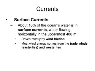
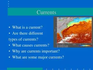
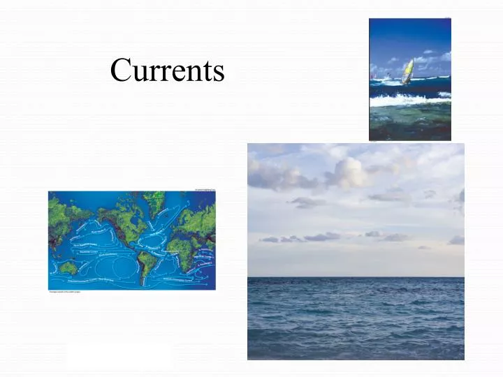
Currents. Causes of Currents. Controlled by several things: Global winds Coriolis Effect Position of continents Density of seawater Warms or cools the air above it, influencing the climate of land near the coast. Coriolis effect. http://www.youtube.com/watch?v=i2mec3vgeaI

E N D
Causes of Currents • Controlled by several things: • Global winds • Coriolis Effect • Position of continents • Density of seawater Warms or cools the air above it, influencing the climate of land near the coast
Coriolis effect • http://www.youtube.com/watch?v=i2mec3vgeaI • Coriolis effect by nova pbs 3 min • http://www.youtube.com/watch?v=dt_XJp77-mk • 2 guys and a ball on a rotating platform by TSGPhysics
Causes of Currents • Variations in water density • When density of seawater in one area is greater than in a neighboring area, it initiates a current • Density Currents are a type of vertical current that carries water from the surface to deeper parts of the ocean • Current flows below the surface as more dense water sinks below less dense water
Causes of Currents • Changes in sea level • Sea level is the average level of the sea’s surface at its mean height between high and low tide • The ocean’s surface is never flat, ocean circulation cause slopes to develop • The steeper the “mound” of water, the larger and faster the current • The force that drives this current is the pressure gradient force
Satellite images show the ocean is “hilly,” not calm or flat • water piles up where currents meet • where currents diverge, “valleys” form http://www.ifm.zmaw.de/research/remote-sensing-assimilation/ssh-and-currents/
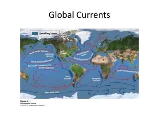
Causes of Currents • Deep and shallow areas of the sea have currents • Surface currents are generally from 0 to about 400 meters (1,300 feet), although some go much deeper • Different phenomena drive surface and deep currents • ocean boundaries force currents to turn; they can’t just keep going in a particular direction • Wind • If the wind blows long enough in one direction,it causes a water current to develop • The current continues to flow until friction dissipates its energy • Near the equator- winds blow ocean water east to west • Closer to the poles – ocean water is blown west to east • The trade winds and the westerlies account for most the Earth’s wind energy
Gyres • combination of westerlies, trade winds, and the Coriolis effect • results in a circular flow in each ocean basin • 5 total
Ekman Transport • because of the Coriolis effect: • Currents have a tendency to flow to the right in the Northern Hemisphere • flow to the left in the Southern Hemisphere • This results in an interesting phenomenon called Ekman transport • Ekman transport was discovered in the 1890s by Fridtjof Nansen
Ekman Transport net motion imparted to the water column down to friction depth called the Ekman transport Ekman Spiral
Ekman Transport • Wind and the Coriolis effect influence waterbelow the surface because water flows in layers • Due to friction, the upper water currents push the water below it. This deeper layer pushes the next layer below it. The process continues downward. Each water layer flows at an angle to the layer above causing a spiral motion • Ekman spiral= spiraling effect of water layers pushing slightly • to the right from the one above in the Northern Hemisphere (90° to the right of the wind ) • to the left (90° to the left ) in the Southern Hemisphere
Dynamic balance • between the clockwise deflection of the Coriolis effect (attempting to move water to the right) • and the pressure gradient created by gravity (attempting to move the water to the left) • The balance keepsthe gyre flowingaround the outsideof the ocean basin.
Western/Eastern Ocean Boundary Currents • currents are created by the Earth’s rotation • results from the balance between the pressure gradient force and the Coriolis effect. • Characteristics of boundary currents.
Western/Eastern Ocean Boundary Currents • Western boundary currents are found on the east coasts of the continents • Stronger and faster than eastern boundary currents • currents flow through smaller areas than eastern boundary currents Formation of eddies.
Western/Eastern Ocean Boundary Currents • Trade winds blow along the equator pushingwater westward • causing it to “pile up” on the western edge of ocean basins before it turns to the poles • earth’s rotation tends to shift the higher surface level in the center of the gyre westward. • higher surface level is now west of center and forces the current to “squeeze” through a narrower area • Western ocean boundary currents handle the same volume, but through smaller areas, so water must move more rapidly
Countercurrents • Another water flows in directions that differ from the major ocean currents • Countercurrents are associated with equatorial currents. • A countercurrent runs in the opposite direction of its adjacent current • North Equatorial Current (NEC) and South Equatorial Current (SEC) flow west until they encounter continents
Undercurrents - Cromwell • An undercurrent flows beneath the adjacent current instead of beside it. • Pacific’s Cromwell Current, named for Townsend Cromwell, who discovered it in 1956 • Cromwell Current flows more than 14,000 kilometers (8,700 miles) from New Guinea to Ecuador • depth of approximately 100 to 200 meters (300 to 600 feet). • average speed of 5 kilometers (3 miles) per hour and carries a volume about half that of the Gulf Stream • Since the discovery of the Cromwell Current, undercurrents have been found beneath most major currents
Upwelling and Downwelling • Upwelling an upward vertical current that brings deep water to the surface • Downwelling a downward vertical current that pushes surface water to the bottom Coastal Upwelling
Upwelling and Downwelling • Coastal upwellings occur when the wind blows offshore or parallel to shore • In the Northern Hemisphere – this wind blowing southward will cause an upwelling only on a west coast the same wind on an east coast sends surface water toward shore causing a downwelling
Upwelling and Downwelling • These currents have strong biological effects: • Upwelling brings deepwater nutrients up into shallow water • Upwellings relate to significant weather patterns • Downwellings remove organic nutrients from the surface, carrying and re-cycling nutrients to deep ocean ecosystems and sediments • Downwelling reduces productivity of some surface species and increases productivity of some bottom species
Upwelling and Downwelling Equatorial Upwelling
Heat Transport and Climate • Currents play a critical role by transporting heat from warm areas to cool areas, moderating temperatures • Without currents moving heat, the world’s climates would be more extreme • The Earth’s cold regions would be colder and the warm regions would be warmer • Winters in northern Europe would be significantly colder without the Gulf Stream bringing heat from the tropics • Southern California owes its mild climate to the moderating effects of the Pacific Ocean. The southerly current along the California coast brings cool water from the north, keeping southern California cooler than it would otherwise be in the summer
El Nino Nov 2013 • http://www.ssec.wisc.edu/data/sst/latest_sst.gif
La Nina http://www.osdpd.noaa.gov/data/sst/anomaly/anomnight.current.gif
El Nino • http://www.youtube.com/watch?v=DbNzw1CCKHo • Visualizing el nino from nasa
El Niño Southern Oscillation • every 3 to 8 years a rearrangement of the high- and low-pressure systems occur • reasons are still not clear Normal El Niño
El Niño Southern Oscillation • El Niño tremendously affects world weather patterns • brings low pressure and high rainfall in the Western Pacific • Brings high pressure and less rainfall in the Eastern Pacific • Called ENSO
El Niño Southern Oscillation • High pressure builds in the Western Pacific and low pressure in the Eastern Pacific • Trade winds weaken or reverse and blow eastward – the southern oscillation • This causes warm water of the west to migrate east to the coast of South America. The loss of upwelling deprives the water of nutrients - A normally productive region declines local fisheries collapse and marine ecosystems dwindle • Over the eastern Pacific, humid air rises causing precipitation in normally arid regions. Flooding, tornados, drought etc can occur
El Niño Southern Oscillation Effects of ENSO.
El Nino and volcanoes • strong correlation between seismic activity on the East Pacific Rise (indicates an eruption) and El Nino cycles over the past ~25 years • Noticed by Dr. Dan Walker at the University of Hawaii • large numbers of underwater volcanoes contribute toward the heating of the oceans • 56 underwater volcanoes having confirmed eruptions in 2001-2002
Deep Circulation and Water Masses • begins when water density increases due to cooling and increased salinity • the denser water sinks • cold dense water stays on the bottom until mixing brings it back to the surface • Tides and internal waves keep deep water mixed • ocean stratifies into density layers • Since water mass characteristics form at the surface, how do deeper layers get to the bottom?
Deep circulation and Water Masses • Based on density stratification • five generally recognized primary water masses: • To about 200 meters (600 feet) - surface water • To the main thermocline (depth varies with latitude) - central water • To about 1,500 meters (5,000 feet) - intermediate water • Below intermediate water, but not in contact with the bottom, to about 4,000 meters (13,000 feet) - deep water • In contact with the seafloor - bottom water
Deep Circulation and Water Masses Layers in the Sea
Deep circulation and Water Masses The Flow of Atlantic Deep Water
How Deep Water Masses Form • intermediate, deep, and bottom water masses form primarily at high latitudes -around 70° North and South • Antarctic Bottom Water and North Atlantic Deep Water, make up most of the world’s deep water • Pacific Deep Water and Mediterranean Deep Water are also important • The densest ocean water forms in the Antarctic during the winter • Antarctic Bottom Water has a salinity of about 34.65‰ and temperature of -0.5˚C (31˚F) • At the surface, its specific density is 1.0279 grams per cubic centimeter, or almost 3% higher than pure fresh water
How Deep Water Masses Form • This high density is due to low temperature and high salinity • As seawater freezes, it leaves salt behind • The water that remains becomes saltier, explaining why Antarctic Bottom Water has such high salinity
How Deep Water Masses Form • According to estimates, about 8 million cubic meters of Antarctic Bottom Waterform every second. • very dense water descends to the bottom, spreads along the Antarctic deep-sea continental shelf and creeps northward • Antarctic Bottom Water reaches as far as 40˚ north latitude, taking somewhat less than 1,000 years to get there • Antarctic Bottom Water is a primary source for both the deep and bottom water layers
How Deep Water Masses Form • In the North Atlantic, high-salinity surface water cools and sinks. • Pacific water that forms in the Northern Hemisphere is not as dense as deep bottom water, so it forms Pacific Intermediate Water. • Intermediate water also develops in the North Atlantic, South Atlantic and South Pacific at latitudes that are not quite as cold as the Arctic or Antarctic. • Mediterranean Deep Water forms due to evaporation rather than cooling.
How Deep Water Masses Form Water Masses This illustration shows a cross-section of the entire Atlantic Ocean looking eastward. Note how the different water masses float or sink, depending on their relative density. Circulation patterns are also indicated.
Deep Water Flow Patterns • enormous water quantities sinking at the poles and in the Mediterranean are the source of the deep water masses and circulation. • bottom water upwells to compensate • rising warm water enters wind-driven currents and is carried to the poles • cools, becomes more dense, and sinks again at the poles
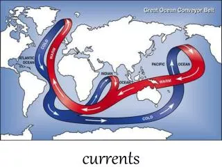
The Ocean Conveyor Belt • Interconnected flow of currents that redistribute heat • Also called the Earth’s air conditioner • deep water and surface currents influence the Earth’s climate
The Ocean Conveyor Belt • Deep water forms at high latitudes • Water from the North Atlantic Deep Water flows south along the Atlantic bottom, merging with Antarctic Bottom Water • From there it flows eastward, with some flowing into the Indian Ocean, but most flowing to the South Pacific • As the water mixes, it rises, warms, and eventually reaches the surface • It is pushed by the trade winds around the ocean • It carries heat from the equatorial regions north and south toward the poles • It cools and descends, starting the cycle again
Gulf Stream from Franklin’s day Benjamin Franklin Was the first to map the gulf stream
Gulf Stream • presented ancient mariners with many challenges • is almost 1 mile (1.6) kilometers deep and can move up to 26 billion gallons of water a second • more than the flow of the Amazon River • caused so many shipwrecks around Cape Hatteras, which juts out sharply from the east coast of North Carolina, that the area is called the graveyard of the Atlantic
Gulf Stream • Carries a volume of water 100x greater than Mississippi River • 25x more water than all rivers in the world • Has eddies at Western boundary
Mediterranean overflow current • well-known density-driven current • Where Mediterranean Sea empties into the Atlantic Ocean • During World War II, submarines used this current to enter and leave the Mediterranean without turning on their engines • With a temperature of 13.4 °C (56.1 °F) and a salinity of 38.4 ppt dense water forming in the Mediterranean Sea is both warmer and saltier than the North Atlantic Central Water (NACW)