Download
1 / 27
270 likes | 387 Views
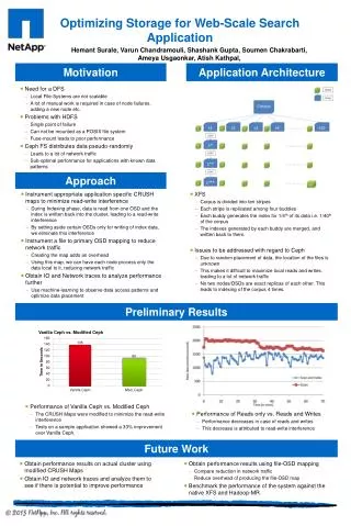
TPB SCENARIO STUDY . CLRP Aspirations Scenario Preliminary Results. Michael Eichler Department of Transportation Planning Presentation to the TPB Technical Committee January 8, 2009. CLRP Aspirations. What Would it Take?.

E N D
TPB SCENARIO STUDY CLRP AspirationsScenarioPreliminary Results Michael Eichler Department of Transportation Planning Presentation to the TPB Technical Committee January 8, 2009
CLRP Aspirations What Would it Take? Draws on past studies and public outreach to provide an ambitious yet attainable vision of land use and transportation for the 2010 CLRP update and to eventually serve as an unconstrained long range plan. Starts with COG regional CO2 goals and assesses what scales and combinations of interventions will be necessary to achieve the goal for the transportation sector. The Two Scenarios
Aspirations Scenario: The Starting Point Baseline • Round 7.2 Cooperative Forecast • 2008 CLRP RMAS Land Use/Transportation Scenarios • More Households Scenario • Households In Scenario • Jobs Out Scenario • Region Undivided Scenario • Transit-Oriented Development Scenario Variably Priced Lanes Scenarios Public Outreach/Feedback on Previous Scenarios
Developing the Aspirations Scenario Goal: To move jobs and housing closer together to create highly accessible and developed areas, and achieve more efficient transportation systems Land Use Decisions Pricing Options Supportive Transit • Address congestion through pricing of new and/or existing lanes • Provide alternatives through enhanced transit • Use menu of transit options from past scenarios • Connect activity centers • Review by Regional Bus Subcommittee • Concentrating projected growth in activity centers and existing/planned transit stations • Consistent review and refinement by planning directors
Scenario Criteria “Within Reach” 1. Land use shifts should be within reach for inclusion in the COG Cooperative Forecast 2. Transportation projects should be financially within reach through developer contributions and pricing.
Consultation with Local Jurisdictions In order to make sure the scenario was aspirational while still being “within reach”, we: 1.Conducted 10 individual jurisdiction meetings with both land use and transportation planners in Alexandria, Arlington, DC, Fairfax, Frederick, Loudoun, Montgomery, Prince George’s, Prince William and VDOT 2.Collected specific comments and incorporated changes into the TAZ-level land use shifts and transit network.
Land Use Component – By The Numbers • Households • Scenario relocates 205,000 households to activity centers and transit station areas • 57% of those “at play” between 2015 and 2030 • 8.2% of the region’s 2030 total • Jobs • Scenario shifts 240,000 jobs to activity centers and transit station areas • 35% of those “at play” between 2015 and 2030 • 5.6% of the region’s 2030 total
Transportation Component: Existing Conditions Freeway system is currently congested and the extent of the congestion will increase by 2030.
Transportation Component: Existing Conditions Existing system of activity centers and high quality transit shows mis-match. Many transit stations without activity and many activity centers without high-quality transit.
CLRP Projects Included in the Baseline The transit projects in the CLRP work to address some of these concerns. Purple Line Corridor Cities Transitway K Street Transitway Dulles Metrorail Columbia Pike Streetcar Anacostia Streetcar Crystal City/Potomac Yard Transitway
RMAS Projects Included in the Scenario Additional projects evaluated under RMAS should be carried forward, with minor modification to provide transit service to additional activity centers. Georgia Ave Transitway Extend Purple Line to New Carrollton VRE Extension to Haymarket US 1 Transitway
Network of Variably Priced Lanes A value pricing study completed by the TPB in February of 2008 evaluated a regional network of variably priced lanes, made up of new capacity and selected existing facilities.
BRT Network for Scenario Study A regional network of BRT operating mostly on the priced lanes will provide high-quality transit service to nearly all activity centers in the region.
BRT Network Routes to and through the Core This network will provide another layer of high-quality transit on top of existing and proposed transit services.
TIGER Grant Application First Step to Regional Network TPB TIGER Grant application, submitted Sept 15, 2009, to act as first step towards this regional network.
BRT to Provide Rail-Like Level of Service • Transit Speeds • 45 MPH on toll lanes • 15 MPH on priority corridors • Headways • 10 minutes, peak • 30 minutes, offpeak • Fare Structure • Same as current services • Will complement existing services • No replacement of current commuter bus services with BRT routes. • BRT complemented by 15 activity center circulator systems with 10-minute headways • Added to activity centers without high quality local bus transit. The Shirlington Transit Station in Arlington, VA.
Transportation Component – By The Numbers • Highways • Scenario creates a 1,600-mile regional priced lane network • 150 priced lane miles in the CLRP • 350 lane miles converted from HOV lanes • 650 new lane miles • 500 lane miles converted from GPLs (DC, Parkways) • Priced lanes target speed: 35 to 45 MPH. • Transit • Scenario creates regional BRT system of nearly 500 miles • 138 BRT stations located in the core, activity centers and existing parking facilities • Plus an additional 140 miles of circulator service
Preliminary Results: Driving Increases • Toll network adds to regional freeway capacity, increasing auto-mobility. • 2008 CLRP for 2030 vs Aspirations Scenario for 2030
Preliminary Results: Congestion Decreases • Average speeds increases, reducing total travel times and delay. • 2008 CLRP for 2030 vs Aspirations Scenario for 2030
Preliminary Results: Transit, Bike-Walk Increase • Moving jobs and households closer together increases bike and walk trips. • New regional BRT system makes transit a more viable option.
!!! Notable Results • 2.2% increase in Households, yet only a 1% increase in motorized trips. • Concentrating households in activity centers provides more bike and walk options. • HOV use virtually unchanged. • Could be result of large increase in transit service. • Total VMT increase of 2.5%, but VMT per Capita only increased 0.3%. • VMT increase due mostly to increase in households.
$ Preliminary Costs and Revenue Estimates $ • Annual Revenues* • Toll Lane Network: $3 billion • In line with results from 2006 pricing study • Transit Network: $100 million • Rough estimate, assumes $2.50 average fare • Capital Costs • Toll Network: $50 billion • From 2006 pricing study • Can be reduced by $10 billion if interchanges not serving activity centers are replaced by slip ramps. • Transit Network: $2 billion • Operating Costs • Toll Network: Incorporated in capital costs • Transit Network: $250 million • A sketch analysis suggests annual revenues approximately equal annualized costs, as with previous pricing study. • *Does not include potential tax-increment financing (value capture) revenues. • Costs in 2010 $
? Topics for Further Investigation ? • How does toll lane speed impact network? • Increase target speed for toll lanes. • Should increase tolls, increase congestion, reduce regional VMT. Impact on total revenue unknown. • What would be the effect of reducing the number of new lane miles? • For example, convert toll network from “add-two” to “add-one-take-one” or price more existing lanes. • Will reduce construction costs while increasing toll rates, revenues and congestion, and reducing VMT. • What is the effect of changing transit service levels? • Explore viability of transit use for both peak and off-peak travel (all trip purposes) by reducing headways.
Next Steps • Briefing on status and preliminary analysis results to Scenario Study Task Force and TPB on January 20, including demand, cost, air quality. • 2.Further analysis, refinements, sensitivity testing and benefit-cost analysis, with regular briefings, February to May. • 3. Final report, June.