Download
1 / 27
330 likes | 567 Views
Grid Point Models. Surface Data. Models: Types. Spectral Models (AVN) Data is not represented on grid Data represented by wave functions Resolution is a function of # waves used in model Computational errors generally less Not well-suited for mesoscale modeling. Models: Types.

E N D
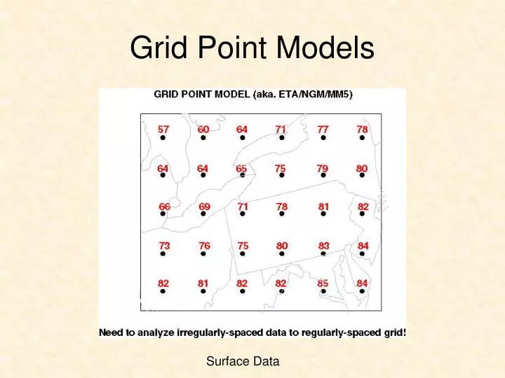
Grid Point Models Surface Data
Models: Types • Spectral Models (AVN) • Data is not represented on grid • Data represented by wave functions • Resolution is a function of # waves used in model • Computational errors generally less • Not well-suited for mesoscale modeling
Models: Types • Hydrostatic Models (ETA, AVN, NGM) • Cannot produce vertical accelerations • Vertical motions determined by the continuity equation • Non-Hydrostatic Models (Some MM5) • Can produce vertical accelerations • Calculate Vertical Motions explicitly • Used in mesoscale applications (conv)
Models: The Basics • Domain: Area covered by the model • IDD grids • Regional vs. Global • Nested models
Models: The Basics • Resolution: Distance between grid points • High and low resolution models • http://www.unidata.ucar.edu/packages/gempak/examples/models/grids/grid211.gif • http://www.unidata.ucar.edu/packages/gempak/examples/models/grids/grid215.gif
Model Resolution Should have 5 to 7 grid points to resolve feature
Model Resolution Should have 5 to 7 grid points to resolve feature
Models: The Basics • What can’t models simulate? • Processes neglected in simplified equations • Processes unknown • Processes that are sub-grid scale • How’s a model to cope?
Models: The Basics • Parameterizations • Model’s attempt to ““simulate”” (incorporate) important sub-grid scale processes • Examples: • Convection • Microphysical processes of precipitation • Surface/Boundary layer fluxes
Why are model forecasts imperfect? • Imperfect Initial Conditions • Too few observations • “Continuous atmosphere = Non-continuous sampling” • some areas worse than others • Bad observations • instrument error • Errors in the initialization procedure • First guess & objective analysis “GI = GO”
Imperfect Models: Accurate Ob = Good ob? Good Observation Or Bad Observation?
Why are model forecasts imperfect? • Imperfect Models • Simplified equations • many “unimportant” terms = 0 • Neglected Processes • that’s why we still have field projects! • Resolution • can’t simulate small scale stuff • ‘good’ ob can be a bad ob
Trend of Numerical Models • Resolution increasing! • Run more frequently! • More models! • Computer power increasing • Cost decreasing
Trend of Numerical Models • Implications: Higher Resolution • Improved initialization • More small-scale effects will be predicted! • Will these small-scale phenomena be correct? • If terrain-forced weather phenomena = YES! • Density obs VS. density grid points • Heightened sensitivity to initial conditions
Higher Resolution: Improves Initialization Good Observation Or Bad Observation? Higher Resolution will help but not solve the problem!
Model Resolution Should have 5 to 7 grid points to resolve feature
Higher Resolution: Improves Terrain-forced weather! Model Terrain vs. Actual Terrain
Model Terrain • ETA 80km • http://lnx21.wwb.noaa.gov/orog/80km_east_crop.gif • ETA 32km • http://lnx21.wwb.noaa.gov/orog/32km_east.gif • ETA 10km • http://lnx21.wwb.noaa.gov/orog/10km_east_crop.gif • Actual terrain • http://fermi.jhuapl.edu/states/us/big_us_color.gif
Density of OBS vs. Grid points What if grid density (aka. model resolution) exceeds observation density?