Download
1 / 58
631 likes | 870 Views
LAND SURVEYS, SITE LOCATION AND MAP READING. Speaker : Engr. Merlito Castor Catolico PRC Accredited Speaker No. 071 Real Estate Broker/Appraiser /Consultant. (4 hours). WHAT IS GEODETIC ENGINEERING ?. GEODETIC ENGINEERING LAW (RA 8560 )

E N D
LAND SURVEYS, SITE LOCATION AND MAP READING Speaker : Engr. Merlito Castor Catolico PRC Accredited Speaker No. 071 Real Estate Broker/Appraiser /Consultant (4 hours)
WHAT IS GEODETIC ENGINEERING ? • GEODETIC ENGINEERING LAW (RA 8560) AN ACT REGULATING THE PRACTICE OF GEODETINC ENGINEERING IN THE PHILIPPINES • The practice of Geodetic Engineering is a professional and organized act of gathering physical data on the surface of the earth with the use of precision instruments.
PRACTICE OF SURVEYING RELEVANT TO REAL ESTATE BROKERAGE • DETERMINE METES AND BOUNDS • is a system or method of describing land, real property (in contrast to personal property) or real estate • Metes = boundary defined by distances and direction • Bounds = more general boundary description • SUBDIVISION / CONSOLIDATION SURVEYS • SKETCH PLAN • PARCELLARY SURVEYS
WHY IS IT IMPORTANT FOR BROKERS TO KNOW BASIC LAND SURVEYING ? • Real Estate Brokers need to know basic surveying • Three elements of space in surveying • Cardinal direction in surveying • How Real Property described • What are the different kinds of land survey • Read maps? • Map symbols • Scale • Topographic maps • Important informations in a map?
DEFINITION OF SURVEYING TERMS • WHAT IS LAND SURVEY? • MAP? • SITE? • LOCATION? • METES AND BOUNDS ? • SUBDIVISION / CONSOLIDATION SURVEYS ? • SKETCH PLAN ? • PARCELLARY SURVEYS ?
COMMON SURVEYING TERMS FOR REAL ESTATE BROKERS BROKERS • Cadastral Survey = creates or re-establishes, marks, and defines boundaries of tracts of lands. • Hectare = 10,000 square meters • Kilometer (km) = 1,000 meters • Meridian (or line of longitude)= true north and south line extending from an initial point in both direction
COMMON SURVEYING TERMS FOR REAL ESTATE BROKERS BROKERS • True Meridian = Line or plane passing through geographical north pole and geographical south pole • Ante meridiem ? (from Latin Meridies or mid-day) • Post meridiem ? • Magnetic Meridians = is an imaginary line connecting the magnetic south and north poles and can be taken as the magnetic force lines along the surface of the earth. • Magnetic Declination = angle between the magnetic and the true meridian • Metes and Bounds = A common method of land description that identifies a property by specifying the shape and boundary dimensions of the parcel, using terminal points and angles.
COMMON SURVEYING TERMS FOR REAL ESTATE BROKERS BROKERS • Original Survey = cadastral survey which creates land boundaries and marks them for the first time • Plat = A surveyed map of a town, section, or subdivision indicating the exact locations and boundaries of individual properties, streets, easements, and public recreation areas. • Setback = Zoning restrictions on the amount of bare land required surrounding improvements; the amount of space required between the lot line and the building line • Subdivision = Land that has been divided by the owner (subdivider) into individual parcels or lots which have been grouped into blocks. These lots, together with streets, alleys, parks, schools, planned commercial areas, and public utility easements, are recorded on a plat
COMMON SURVEYING TERMS FOR REAL ESTATE BROKERS BROKERS • Survey = The process by which boundaries are measured and the locations or forms of land areas are determined • Easement = areas of land owned by the property owner, but in which other parties, such as utility companies, may have limited rights granted for a specific purpose. • Right-of-way = a parcel of land granted by deed or easement for construction and maintenance according to a designated use. This may include highways, streets, canals, ditches, or other uses • Latitude = A measure of relative position north or south on the Earth's surface, measured in degrees from the equator, which has a latitude of 0°, with the poles having a latitude of 90° north and south • Longitude = is a geographic coordinate that specifies the east-west position of a point on the Earth's surface
COMMON SURVEYING TERMS FOR REAL ESTATE BROKERS BROKERS • Prime Meridian = the longitude that passes through the Royal Observatory, Greenwich, England, establishes the position of zero degrees longitude. • Mean Sea Level = is a measure of the average height of the ocean's surface (such as the halfway point between the mean high tide and the mean low tide) • Datum = is a reference from which measurements are made • Contour Lines = a line on a map joining points of equal height above or below sea level • Topographic Map = is a type of map characterized by large-scale detail and quantitative representation of relief
How to Determine Elevation Using Topographic Map • Find the location of the point in the map • Look for the Index Contour • Find the elevation • Determine the direction of the slope • Count the contour intervals • Interpolate http://raider.mountunion.edu/~mcnaugma/ topographic%20maps/contour.htm
COMMON SURVEYING TERMS FOR REAL ESTATE BROKERS BROKERS • Bearings = Bearings are used to indicate angular orientation with respect to the earth • Benchmark = A survey mark made on a monument having a known location and elevation, serving as a reference point for surveying. • Tie Line = A survey line that connects a point to other surveyed lines • Property Line = describes the legal boundary of a parcel of land • BLLM = Bureau of Lands Location Monument
COMMON SURVEYING TERMS FOR REAL ESTATE BROKERS BROKERS • TCT = Transfer Certificate of Title • OCT = Original Certificate of Title • Free-Patent = is a legitimate proof of ownership of public land in the Philippines granted by the Philippine government. It is an agreement between the government and the grantee, that he or she is charged of developing the land within a specified period of time. • Consolidation and Subdivision Survey = land survey of more than two contiguous lots merging to form a single lot, and a single lot subdivided into two or more lots, respectively.
COMMON SURVEYING TERMS FOR REAL ESTATE BROKERS BROKERS • CAD = Cadastral Survey • Csd= subdivision survey of Cadastral Lot • Psd = subdivision survey of a titled properties. All Psd surveys are conducted by a Private Geodetic Engineer • Bsd- Is a subdivision survey on government titled properties conducted by a Government Geodetic Engineer. If a private titled land is being surveyed by a Government Geodetic Engineer thru court order, the resulting survey is aBsd. • Psu - is a survey on original land (not yet surveyed) by a private Geodetic Engineer. This kind of survey will be used by titling thru judicial proceedings (means thru court order). • FP - Free Patent survey by a Private Geodetic Engineer
COMMON SURVEYING TERMS FOR REAL ESTATE BROKERS BROKERS • Triangulation= a series of connected triangles which adjoin or overlap each other, with angles being measured from determined fixed stations • Trilateration = uses electronic distance measuring equiAMent to directly measure the lengths of the sides of triangles from which the angles can be calculated • Traverse = consists of a series of lines, whose lengths and directions are measured, connecting points whose positions are to be determined • open traverse begins at a point of known position and ends at a station whose relative position is unknown. • closed traverse begins and ends at the same point whose position is known
COMMON SURVEYING TERMS FOR REAL ESTATE BROKERS BROKERS • Leveling is the operation of determining differences of elevation by measuring vertical distances directly on a graduated rod with the use of a leveling instrument such as a dumpy level, transit or Theodolites. This method is called Direct Leveling or Differential leveling • Indirect leveling can be done using the principle that differences in elevation are proportional to the differences in atmospheric pressure • Radiationis a surveying technique often used in conjunction with a plane table
LAND SURVEYS FOR REAL ESTATE BROKERS
Land Surveying • is the science and art of making all essential measurements to determine the relative position of points or physical and cultural details above, on, or beneath the surface of the Earth, and to depict them in a usable form, or to establish the position of points, or details. • Surveying Uses : • Mathematics • Geometry • Trigonometry • Physics • Engineering • Law
TWO TYPES OF SURVEY • Plane surveying = considers the earth to be a flat surface-- a plane • Geodetic surveying = takes into account the true shape of the earth.
TYPES OF SURVEYING ACCORDING TO USE Detailed Engineering: These are carried for engineeringfeasibility studies, ground terrain analysis, design planning and during actual construction phase. • Topographic Survey • Contour Mapping • Hydrographic Survey • Construction Layout • Highway & Bridge Design Survey • As-built Construction Survey
TYPES OF SURVEYING ACCORDING TO USE Ground Control Establishment : These are carried in surveys that require a high degree of accuracy with regards to both relative and absolute geodetic position. • GPS Geodetic Control Survey • Vertical Control Leveling
TYPES OF SURVEYING ACCORDING TO USE Property Boundary : These surveys are carried primarily to determine and establish the legal boundary of real properties. • Cadastral Survey • Parcellary Survey • Subdivision Consolidation Survey • Boundary Relocation Survey
TYPES OF SURVEYING ACCORDING TO USE Route Alignment : These services are required during the design & actual construction of road alignment and river embankment structures to determine the condition of the existing terrain. • Road Alignment • Profile Cross-Section Survey • River Survey
THREE ELEMENTS OF SPACE IN SURVEYING • DISTANCE = the extent or amount of space between two things, points, lines, etc. • DIRECTION = a position on a line extending from a specific point toward a point of the compass or toward the nadir or the zenith • ELEVATION = height above a fixed reference point
FOUR CARDINAL POINTS IN SURVEYING • NORTH • SOUTH • EAST • WEST
ROUGH DISTANCE MEASUREMENT PACING • Distance = Pace factor × Number of Paces
Determine your Pace Factor Homework: A Real Estate Broker walked along a given straight line in a horizontal ground that was known to be 60 m long, in order to determine her average unit pace. She paced the line five times, recording 78, 76.5, 77, 87, and 76 paces, respectively. • Determine her average unit pace, or Pace Factor (PF). b. If the said broker then counted an average of 123.5 paces while pacing off the line of unknown distance, what is the distance? Remarks: Pace Factor (PF) = Distance ÷ Average Paces
Other Ways to Measure Distances • Taping EquiAMents • clisimeter • Transit, or Level; and stadia • Total Station • EDM
THE MEASURING WHEEL A simple measuring wheel mounted on a rod can be used to determine distances, by pushing the rod and rolling the wheel along the line to be measured. An attached device called an odometer serves to count the number of turns of the wheels From the known circumference of the wheel and the number of revolutions, distances for reconnaissance can be determined with relative accuracy of about 1:200.
WHAT IS A COMPASS ? • WHAT IS A COMPASS? • is a navigational instrumentthat measures directions in a frame of reference that is stationary relative to the surface of the earth • The frame of reference defines the four cardinal directions (or points) – north, south, east, and west. • Intermediate directions are also defined. • a diagram called a compass rose, which shows the directions (with their names usually abbreviated to initials), is marked on the compass.
An iPhonecan be used as a geological compass because of the 3-axis teslameter and 3-axis accelerometer inside it
WHY IS IT NECESSARY TO KNOW HOW TO USE A COMPASS • What is a compass survey? (BONUS PRESENTATION FOR YOUR INFO – STUDY LATER ) • It is used for you to find north. The arrow that stays in a direction points north . • Can used for orienting a map • Can be use to find direction • Can be use to find location
ORIENTING A MAP • Orienting, or aligning, the map is really easy with just 3 steps: • Lay your map out on a relatively flat, smooth surface. • Turn your declination-adjusted compass dial so due North is at the index pointer. • Place your compass on your map with the edge of the base plate parallel to the north-south meridians on the map. • Turn the map and compass together until the compass needle is "boxed" in the orienting arrow
HOW TO FIND TRUE NORTH WITHOUT A COMPASS The Shadow-Tip Method • Place a stick upright in the ground so that you can see its shadow. Alternatively, you can use the shadow of a fixed object. Nearly any object will work, but the taller the object is, the easier it will be to see the movement of its shadow, and the narrower the tip of the object is, the more accurate the reading will be. Make sure the shadow is cast on a level, brush-free spot. • Mark the tip of the shadow with a small object, such as a pebble, or a distinct scratch in the ground. Try to make the mark as small as possible so as to pinpoint the shadow's tip, but make sure you can identify the mark later. • Wait 10-15 minutes. The shadow tip will move mostly from west to east in a curved line. • Mark the new position of the shadow's tip with another small object or scratch. It will likely move only a short distance. • Draw a straight line in the ground between the two marks. This is an approximate east-west line. • Stand with the first mark (west) on your left, and the other (east) on your right.You are now facing mostly toward true north, regardless of where you are in the world. This method is based on the fact that the sun moves across the sky from East to West.
What is Latitude and Longitude Lines of Latitude Example: Equator = “0 °” latitude Lines of Longitude • Also called “meredian” • “0 ° “ Longitude passes at Greenwich, England • (by convention)
Why Orient a Map? • If you know where you are on the map, you should be able to look in any direction and see the objects represented on the map in the same direction. • If you can see a known mountain in one direction and a lake off another way, then just lay the map out, and turn it so the corresponding marks on the map align with the distant features. • You can verify the location of your subject property – on the ground
USING A RULER FIND THE FASTEST WAY TO MEASURE THE HEIGHT OF THE 7 STOREY BUILDING?
DEFINITION OF TERMS • LAND = the Earth's surface extending downward to the center of the Earth and upward to infinity, including permanently attached natural objects. • SITE = a parcel of land which improved to the extent that it is ready for use for the purpose of which it is intended • LOT = is a tract or parcel of land owned or meant to be owned by some owner(s), with documented defined boundaries (or borders) • LOCATION = an economic characteristic of real estate composed of immobility, constant change, dependence, and elements of special distribution • REAL ESTATEincludes everything in the definition of Land, plus all things permanently attached to it naturally or artificially. • REAL PROPERTYincludes Real Estate plus the interests, benefits and rights automatically included with the ownership of the Real Estate - Possession, Control, Enjoyment, Exclusion, and Disposition.
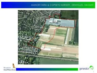
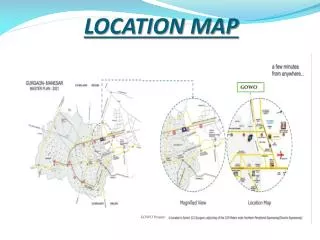
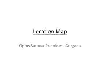
IMPORTANT DATA NEEDED FOR SITE LOCATION • Direction (Using internet, example: Google earth) • Lot Plan / Vicinity Map / Location Map • Means of Transportation • Access Roads/Routes • Reference Point (adjacent properties / land marks) and Specific Distances, or Time Frame • Land Use • Contact persons
SOURCES OF DATA FOR SITE LOCATION • Survey Maps • Vicinity or Location Map • Tax map • Land Title • Sketch Plan • Owner • Owner’s Agent • Internet (ie… Google Map) • Barangay/ Purok Officials • Neighbors
HOW TO IDENTIFY PROPERTY IN A SITE LOCATION • Technical Approach • By relocation Survey • Layman’s Approach • Direction of a knowledgeable person • Semi-Skilled Approach • Sketching/Plotting with the use of: • Compass and Tape • Angular estimate and Pacing • Use of a GPS