Download
1 / 10
100 likes | 198 Views
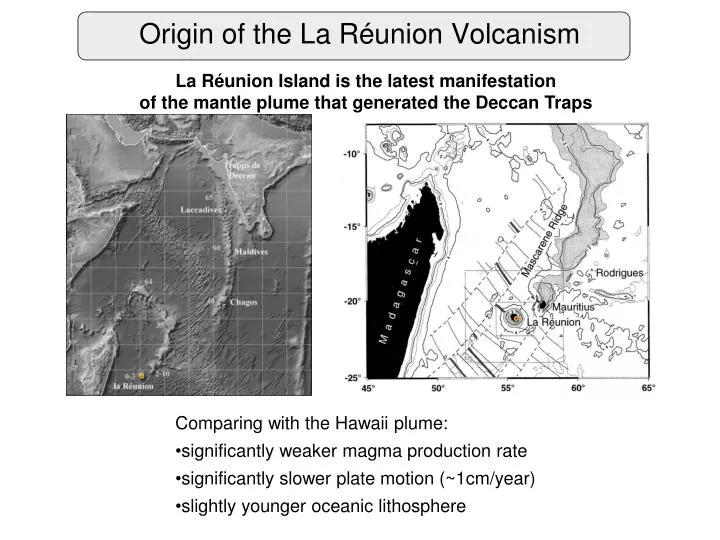
Origin of the La Réunion Volcanism. La Réunion Island is the latest manifestation of the mantle plume that generated the Deccan Traps. Comparing with the Hawaii plume: significantly weaker magma production rate significantly slower plate motion (~1cm/year)

E N D
Origin of the La Réunion Volcanism La Réunion Island is the latest manifestation of the mantle plume that generated the Deccan Traps • Comparing with the Hawaii plume: • significantly weaker magma production rate • significantly slower plate motion (~1cm/year) • slightly younger oceanic lithosphere
La Réunion Island and Piton de la Fournaise Volcano 70 km Piton des Neiges (3069 m, last eruption 12 ka) Laboratory of GeoSciences at La Reunion University (LGSR) La Réuinion: French Overseas Department 2512 km2 840000 hab. Piton de la Fournaise (2632 m, presently active) Piton de la Fournaise Volcano Observatory (OVPF)
Piton de la Fournaise geophysical monitoring networks • Before 2009 • Seismic network was mostly composed of short-period one-component instruments with analogous data transmission • Deformation measurements were mostly concentrated on the main edifice • Digital seismic data started in 80-s • Continuous seismic data started in 1999
Piton de la Fournaise new Seismic and GPS networks Since 2009: 3C broad-band seismic stations with continuous recording + continuous GPS. GPS network Broad-band seismic network More information in the poster by Philippe Kowalski M14 “Evolution of monitoring networks of Piton de la Fournaise volcano over 30 years” and the poster by Thomas Staudacher TU21 “Permanent and cinematic GPS network at Piton de la Fournaise”
La Réunion data distribution VOLOBSIS portal: http://volobsis.ipgp.fr ; archived and real-time (seedlink) data available 49 seismic stations 25 GPS stations More data will be open for distribution soon: inclinometry, extonsometers, geochemistry
French Antilles data distribution VOLOBSIS portal: http://volobsis.ipgp.fr ; archived and real-time (seedlink) data available 62 seismic stations 12 GPS stations More data will be open for distribution soon: inclinometry, extonsometers, geochemistry
Piton de la Fournaise recent volcanic activity from Vlastelic et al. (2009) Latest major eruption in 2007
Piton de la Fournaise Volcano Observatory (OVPF) • Created in 1979 • Funded by IPGP, CNRS, and La Réunion authorities • Current team of 4 scientists and 7 technical and administrative staff • Operates geophysical and geochemical monitoring networks • Digital continuous seismic records are available since 1999 • Major upgrade of the seismic and GPS networks in 2009 with the UNDERVOLC project Presentation by the OVPF members at the Chapman conference: Philppe Kowalsky, M14 poster Andrea Di Muro, talk this afternoon Thomas Staudacher, TU20 and TU21 posters
Piton de la Fournaise geophysical monitoring networks • Before 2009 • Seismic network was mostly composed of short-period one-component instruments with analogous data transmission • Deformation measurements were mostly concentrated on the main edifice • Digital seismic data started in 80-s • Continuous seismic data started in 1999
Piton de la Fournaise new Seismic and GPS networks Since 2009: 3C broad-band seismic stations with continuous recording + continuous GPS. GPS network Broad-band seismic network More information in the poster by Philippe Kowalski M14 “Evolution of monitoring networks of Piton de la Fournaise volcano over 30 years” and the poster by Thomas Staudacher TU21 “Permanent and cinematic GPS network at Piton de la Fournaise”